Bromley, Kentucky facts for kids
Quick facts for kids
Bromley, Kentucky
|
|
|---|---|

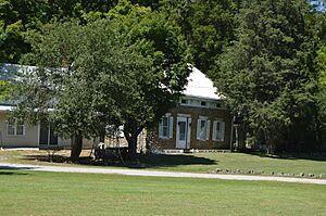
Pleasant Run Stone House I south of Bromley
|
|

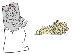
Location of Bromley in Kenton County, Kentucky
|
|
| Country | United States |
| State | Kentucky |
| County | Kenton |
| Area | |
| • Total | 0.51 sq mi (1.31 km2) |
| • Land | 0.38 sq mi (0.97 km2) |
| • Water | 0.13 sq mi (0.34 km2) |
| Elevation | 505 ft (154 m) |
| Population
(2020)
|
|
| • Total | 724 |
| • Density | 1,930.67/sq mi (745.92/km2) |
| Time zone | UTC-5 (Eastern (EST)) |
| • Summer (DST) | UTC-4 (EDT) |
| ZIP codes |
41016-41017
|
| Area code(s) | 859 |
| FIPS code | 21-09856 |
| GNIS feature ID | 2403932 |
Bromley is a small city in Kenton County, Kentucky, Kentucky, United States. It is located right along the Ohio River. In 2020, about 724 people lived there. Bromley is part of the larger Cincinnati metropolitan area.
Contents
History of Bromley
The story of Bromley began in 1784. That year, a person named Prettyman Merry received a large piece of land from the United States government. This land was about 2,000 acres (8.1 km²).
Soon after, the Merry family started building a home on their new land. This old house is still standing today on Shelby Street.
Bromley officially became a city on May 23, 1890. The state of Kentucky approved its incorporation.
Geography of Bromley
Bromley is located in the northern part of Kenton County. It sits on the south bank of the Ohio River. To its northeast is the city of Ludlow. To its southwest is Villa Hills. South of Bromley is Crescent Springs. Across the river to the north, in Ohio, is the big city of Cincinnati.
The closest river crossing is the Brent Spence Bridge, about 3 miles (4.8 km) to the east. This bridge carries major highways, I-71 and I-75.
Kentucky Route 8 runs through the middle of Bromley. This road goes northeast towards Ludlow and Covington. It also goes west along the river through Villa Hills to Taylorsport.
Bromley covers a total area of about 0.51 square miles (1.31 km²). Most of this is land, but about 0.13 square miles (0.34 km²) is water, mainly from the Ohio River.
Some streets in Bromley are named after important historical figures from Kentucky. For example, Shelby Street is named after Isaac Shelby. Boone Street is named after Daniel Boone. And Kenton Street is named after Simon Kenton.
Population of Bromley
| Historical population | |||
|---|---|---|---|
| Census | Pop. | %± | |
| 1900 | 543 | — | |
| 1910 | 819 | 50.8% | |
| 1920 | 736 | −10.1% | |
| 1930 | 1,017 | 38.2% | |
| 1940 | 876 | −13.9% | |
| 1950 | 980 | 11.9% | |
| 1960 | 998 | 1.8% | |
| 1970 | 1,069 | 7.1% | |
| 1980 | 844 | −21.0% | |
| 1990 | 1,137 | 34.7% | |
| 2000 | 838 | −26.3% | |
| 2010 | 763 | −8.9% | |
| 2020 | 724 | −5.1% | |
| U.S. Decennial Census | |||
In 2000, there were 838 people living in Bromley. These people lived in 342 households, and 221 of these were families. Most of the people living in Bromley were White.
About 30% of households had children under 18. Many households were married couples living together. Some households had a female head without a husband. Others were individuals living alone, including some who were 65 or older.
The average age of people in Bromley was 34 years old. About 26.5% of the population was under 18. About 14% of the population was 65 or older.
Education in Bromley
Most students in Bromley attend schools in the Ludlow Independent School District. However, some parts of Bromley are in the Kenton County School District.
See also
 In Spanish: Bromley (Kentucky) para niños
 | Selma Burke |
 | Pauline Powell Burns |
 | Frederick J. Brown |
 | Robert Blackburn |

