
Mill Creek (Ohio) facts for kids
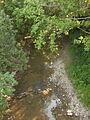
The Mill Creek is a stream located in southwest Ohio. It flows for about 28.4 miles (45.7 km) (that's around 45 kilometers!) from its starting point in West Chester in Butler County. From there, it travels through the middle of Hamilton County and right through the heart of Cincinnati. Finally, it empties into the Ohio River just west of downtown Cincinnati.
You might have heard of the Mill Creek Expressway, which is the name for the section of Interstate 75 that runs through Cincinnati. This area is special because the Mill Creek Valley is actually a leftover from a much older, bigger Deep Stage Ohio River that existed during the Last Glacial Maximum (a time when huge glaciers covered much of the Earth!).
The stream, with its powerful water and useful valley, was super important for Cincinnati as it grew. For a while, the steep hills around the creek made it hard for the city to expand. This led to other communities growing freely over those hills. Later, special inclined planes (like outdoor elevators) helped people get over these hills. Today, highways and cars make it much easier to travel around the valley.
Contents
Why Is the Mill Creek Important?
The Mill Creek has played a big role in the history of Cincinnati. Its water power was used by many early industries, helping the city become a busy center for manufacturing. The valley itself provided a natural path for transportation and development.
The Mill Creek's Environmental Story
Throughout Cincinnati's history, many factories and industries were built along the Mill Creek. Unfortunately, this also meant that the creek became very polluted.
Pollution Challenges
At the start of the 1900s, people even called the Mill Creek "a great open city sewer" because of how dirty it was. Later, in 1997, it was sadly described as "the most endangered urban river in America." This shows how much pollution affected the creek over time.
Working Towards a Cleaner Future
Luckily, many people and groups are now working hard to clean up the Mill Creek. They want to make it a healthy place for wildlife and for people to enjoy again. This includes removing pollution, restoring natural habitats, and educating the community about protecting the environment.
How Does Water Flow in the Mill Creek?
Scientists use special tools called stream gauges to measure how much water flows in rivers and streams. A USGS stream gauge on the Mill Creek in Cincinnati, near Mitchell Avenue, measured the average amount of water flowing through it.
Measuring Water Flow
During certain years (1942-1943 and 1946-1947), the average flow was about 115.9 cubic feet per second (3.28 m3/s). This measurement helps experts understand the creek's water levels and how it changes over time.
Bridges Over the Mill Creek
Because the Mill Creek Valley is a significant natural feature, many bridges and viaducts (which are like long bridges that cross valleys) have been built to go over it. These crossings help people and trains travel across the valley, connecting different parts of the city.
Major Crossings
Some of the important crossings over the Mill Creek, from south to north, include:
- Sixth Street Expressway/Waldvogel Viaduct (part of U.S. Route 50)
- Eighth Street Viaduct
- Western Hills Viaduct
- Hopple Street Viaduct
- Interstate 74
- Ludlow Viaduct (which carries US 127)
- Interstate 75 (which crosses the creek multiple times)
- State Route 126 (also known as the Ronald Reagan Cross County Highway)
- Interstate 275
These bridges are vital for transportation and show how the city has built around and over the Mill Creek to grow and connect its communities.

Images for kids
-
Mill Creek
