Harrison, Ohio facts for kids
Quick facts for kids
Harrison, Ohio
|
|||
|---|---|---|---|

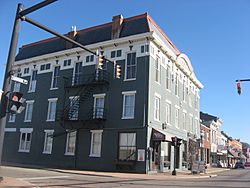
Harrison Avenue at Walnut Street in Harrison
|
|||
|
|||

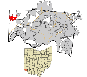
Location in Hamilton County and the state of Ohio
|
|||
| Country | United States | ||
| State | Ohio | ||
| County | Hamilton | ||
| Area | |||
| • Total | 5.37 sq mi (13.91 km2) | ||
| • Land | 5.34 sq mi (13.83 km2) | ||
| • Water | 0.03 sq mi (0.08 km2) | ||
| Elevation | 584 ft (178 m) | ||
| Population
(2020)
|
|||
| • Total | 12,563 | ||
| • Estimate
(2023)
|
13,320 | ||
| • Density | 2,352.18/sq mi (908.17/km2) | ||
| Time zone | UTC-5 (Eastern (EST)) | ||
| • Summer (DST) | UTC-4 (EDT) | ||
| ZIP code |
45030
|
||
| Area code(s) | 513 | ||
| FIPS code | 39-33838 | ||
| GNIS feature ID | 2394305 | ||
Harrison is a city in western Hamilton County, Ohio, United States. It's a part of the larger Cincinnati metropolitan area. In 2020, about 12,563 people lived here.
Contents
History of Harrison
Harrison was first planned out in 1810. It was named after William Henry Harrison, who was a famous general and later became the ninth president of the United States. Harrison officially became a town in 1850 and then a city in 1981.
Harrison Township was created in 1853. One old building nearby is the Eighteen Mile House, built in the early 1800s.
Harrison was once home to Ohio's fifth governor, Othneil Looker. It was also a stop on the Whitewater Canal, which was a waterway built between 1836 and 1847. This canal stretched for about 76 miles.
In 1863, during the American Civil War, a group of Confederate soldiers called Morgan's Raiders came through Harrison. They took fresh horses and burned a bridge over the Whitewater River. The first train arrived in Harrison Township in 1864. The Harrison Depot, a train station, was built in 1882 but later burned down.
Harrison Village Park is where some soldiers from the Revolutionary War are buried. In the park's center is a bandstand. It was built in the early 1930s where a fountain used to be. The fountain was drained and filled in because of health concerns.
In 1940, a dog track in West Harrison closed down. This happened because of pressure from the horse racing world. The track had opened in 1932, when betting on races was not allowed in Indiana. However, during the Great Depression, the track brought in money and offered good jobs for the time.
On June 2, 1990, parts of Harrison were badly damaged by a strong tornado. But the city was quickly rebuilt.
Harrison is also where the main office of the American Watchmakers-Clockmakers Institute is located. This group helps people learn about making and fixing watches and clocks.
Since 2023, Harrison has a special friendship with a town in Germany called Meckesheim.
Geography of Harrison
Harrison is located in the northwest part of Hamilton County. To its west is the town of West Harrison, Indiana.
Interstate 74 goes through the city, just east of the downtown area. You can get on or off the highway at Exits 1 and 3. Interstate 74 leads southeast about 21 miles to Cincinnati and northwest about 93 miles to Indianapolis.
The city of Harrison covers a total area of about 4.96 square miles. Most of this (4.92 square miles) is land, and a small part (0.04 square miles) is water.
Harrison is right next to Miami Whitewater Forest. This is a large park that joined the Hamilton County Park District in 1949. It now covers about 4,345 acres.
Population in Harrison
| Historical population | |||
|---|---|---|---|
| Census | Pop. | %± | |
| 1830 | 173 | — | |
| 1850 | 940 | — | |
| 1860 | 1,343 | 42.9% | |
| 1870 | 1,417 | 5.5% | |
| 1880 | 1,560 | 10.1% | |
| 1890 | 1,690 | 8.3% | |
| 1900 | 1,456 | −13.8% | |
| 1910 | 1,368 | −6.0% | |
| 1920 | 1,309 | −4.3% | |
| 1930 | 1,449 | 10.7% | |
| 1940 | 1,656 | 14.3% | |
| 1950 | 1,943 | 17.3% | |
| 1960 | 3,878 | 99.6% | |
| 1970 | 4,408 | 13.7% | |
| 1980 | 5,855 | 32.8% | |
| 1990 | 7,518 | 28.4% | |
| 2000 | 7,487 | −0.4% | |
| 2010 | 9,897 | 32.2% | |
| 2020 | 12,563 | 26.9% | |
| 2023 (est.) | 13,320 | 34.6% | |
| Sources: | |||
2020 Census Information
In 2020, Harrison had 12,563 people living there. This means there were about 2,352 people per square mile. There were 5,046 homes in the city.
Most of the people living in Harrison (93.3%) were White. About 0.8% were Black or African American, and 0.8% were Asian. About 1.6% of the population identified as Hispanic or Latino.
There were 4,896 households. In 36.4% of these homes, there were children under 18. About 57.3% of households were married couples living together.
About 27.6% of the people in Harrison were under 18 years old. Most people (59.3%) were between 18 and 64. About 13.1% were 65 or older. The average age was 36.9 years.
The average yearly income for a household in Harrison was estimated to be $88,943. About 4.8% of the people in Harrison lived below the poverty line. This included 5.6% of those under 18.
2010 Census Information
In 2010, Harrison had 9,897 people. There were 3,765 households, including 2,659 families. The population density was about 2,011 people per square mile.
About 97.6% of the people were White. About 1.1% of the population was Hispanic or Latino.
In 37.8% of the households, there were children under 18. About 51.7% of households were married couples.
The average age was 34.7 years. About 26.2% of residents were under 18. About 28.1% were between 25 and 44 years old.
Education in Harrison
- William Henry Harrison High School is located in Harrison. This school is part of the Southwest Local School District. This district covers Harrison Township, Crosby Township, and Whitewater Township in Hamilton County. It also includes a small part of Morgan Township in Butler County.
- Cincinnati State Technical and Community College West Campus is also in Harrison. This college offers technical and community education.
- St. John the Baptist Harrison is a Roman Catholic school. It has about 305 students from preschool up to eighth grade. The school's sports teams are called the Jaguars, and their colors are red and black.
Notable people
- Harriet Ball Dunlap, a leader in the temperance movement (a movement against alcohol).
Images for kids
See also
 In Spanish: Harrison (Ohio) para niños
 | Georgia Louise Harris Brown |
 | Julian Abele |
 | Norma Merrick Sklarek |
 | William Sidney Pittman |


