
Curtis, Michigan facts for kids
Quick facts for kids
Curtis, Michigan
|
|
|---|---|
.jpg)
Looking east along Main Street (H-42)
|
|

Curtis, Michigan
Location in Michigan

Curtis, Michigan
Location in the United States
|
|
| Country | United States |
| State | Michigan |
| County | Mackinac |
| Township | Portage |
| Settled | 1884 |
| Established | 1905 |
| Platted | 1906 |
| Elevation | 699 ft (213 m) |
| Time zone | UTC-5 (Eastern (EST)) |
| • Summer (DST) | UTC-4 (EDT) |
| ZIP code(s) |
49820
49836 (Germfask) |
| Area code(s) | 906 |
| GNIS feature ID | 624228 |
Curtis is a small, friendly community in Michigan's Upper Peninsula. It's not a city or a town with its own government. Instead, it's a special area within Portage Township in Mackinac County. Curtis is famous for its beautiful lakes, making it a popular spot for visitors who love fishing and outdoor fun. It even has its own post office with the 49820 ZIP Code.
Contents
History of Curtis
How Curtis Began
.jpg)
The land where Curtis is now was first home to the Chippewa people. The first white settler, John Lee, arrived in 1884. He lived with the Chippewa, even sharing a hut with Chief Saw-Naw-Quato for a year and a half.
In 1886, the government gave land ownership to John Lee and some Chippewa members. Lee settled by South Manistique Lake. Soon, more families and settlers moved to the area.
Naming the Community
The new community was first called Portage. It was located on a narrow strip of land between Manistique Lake and South Manistique Lake. The name changed to Curtis when a post office opened on November 15, 1905. The community was named after William L. Curtis, a politician who was a state senator from 1902 to 1906.
In 1906, the community was officially "platted," which means its streets and lots were mapped out. It was also sometimes called Sawaquanto Beach. The post office has been open ever since and is still in the center of Curtis today.
Growth and Changes
.jpg)
By 1907, Curtis had about 75 people. It had two general stores, two hotels, and places for laundry. That year, a railway line was built by the Manistique and Lake Superior Railroad. Curtis got a train depot, connecting it to many lumber towns in the Upper Peninsula.
Many cottages and resorts were built, hoping Curtis would grow as lumber was harvested. However, the railroad stopped using the depot soon after, in 1910. By 1913, the population dropped to only 25 people. The remaining residents then focused on farming and fishing. The depot was eventually taken down, and the railway lines were removed. Curtis kept going and slowly grew because of its many lakes, which offered great hunting and fishing.
Roads and Travel
Without the railway, Curtis relied on roads. M-135 was a state highway built in 1928. It ran just east of Curtis, connecting to M-28 north and US 2 south. This highway was changed in 1960.
In 1970, the road became H-33. Also in 1970, the main road through Curtis became H-42 (Main Street). H-42 connects to M-77 to the west and H-33 to the east.
Woodlawn Cemetery
The Woodlawn Cemetery, also known as the Curtis Cemetery, is located in the community. It was started in 1930, but its oldest grave dates back to 1910.
Geography of Curtis
Where is Curtis?

Curtis is in the middle of Portage Township in Michigan's Upper Peninsula. It's about 65 miles (105 km) west of the Mackinac Bridge. Curtis is about 699 feet (213 meters) above sea level.
Lakes and Waterways
Curtis is a popular place for tourists because it's surrounded by many lakes. These include the three Manistique Lakes (Manistique Lake, North Manistique Lake, and South Manistique Lake), as well as Milakokia Lake and Millecoquins Lake. There's also the smaller Lake Ann Louise.
Portage Creek flows through the center of Curtis. This creek connects Manistique Lake in the north with South Manistique Lake. The community is located on a narrow piece of land between these two larger lakes.
Nearby Areas and Services
Curtis is centered along H-42 (Main Street). This road goes west to connect with M-77. H-42 ends at H-33 (Manistique Lakes Road) just east of Curtis. H-33 goes north to M-28 and south to U.S. Highway 2.
Other nearby communities include Helmer and McMillan to the north, Germfask to the northwest, and Gould City to the south.
The Curtis post office uses the 49820 ZIP Code. This ZIP Code covers the central part of Portage Township and a small part of Lakefield Township in Luce County. Some areas west of Curtis might use the Germfask 49836 ZIP Code. Curtis is also part of the Tahquamenon Area Schools district, which is the largest public school district in Michigan.
The Portage Township Offices are located in Curtis. Because of all the nearby lakes, the Michigan Department of Natural Resources has many public boat launches in the Curtis area. Two of the closest boat launches are on the southern shores of Manistique Lake.
Images for kids
-
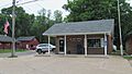
U.S. Post Office in Curtis
-
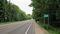
Road signage along Main Street
-
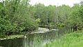
Portage Creek along H-33


_June_2021.jpg)
