
Pellston, Michigan facts for kids
Quick facts for kids
Pellston, Michigan
|
|
|---|---|
|
Village
|
|
| Village of Pellston | |

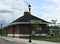
Downtown Pellston along U.S. Route 31
|
|
| Nickname(s):
Ice Box of the Nation
|
|
,_MI_location2.png)
Location within Emmet County
|
|

Pellston, Michigan
Location in Michigan
|
|
| Country | United States |
| State | Michigan |
| County | Emmet |
| Townships | Maple River and McKinley |
| Government | |
| • Type | Village council |
| Area | |
| • Total | 1.95 sq mi (5.05 km2) |
| • Land | 1.95 sq mi (5.05 km2) |
| • Water | 0.00 sq mi (0.00 km2) |
| Elevation | 699 ft (213 m) |
| Population
(2020)
|
|
| • Total | 774 |
| • Density | 396.92/sq mi (153.25/km2) |
| Time zone | UTC-5 (Eastern (EST)) |
| • Summer (DST) | UTC-4 (EDT) |
| ZIP code(s) |
49769
|
| Area code(s) | 231 |
| FIPS code | 26-63300 |
| GNIS feature ID | 0634571 |
Pellston is a small village located in Emmet County, Michigan. In 2010, about 822 people lived there. Pellston is also home to the Pellston Regional Airport.
The village is found where Maple River and McKinley townships meet. It sits along US Highway 31. Interstate 75 is about 10 miles (16 km) east of Pellston. Famous nearby places include Mackinaw City and the Mackinac Bridge, which are about 18 miles (29 km) north. Petoskey is about 20 miles (32 km) southwest. The University of Michigan Biological Station is also close by, on Douglas Lake.
Contents
Population and People
This section tells us about the number of people living in Pellston over the years.
| Historical population | |||
|---|---|---|---|
| Census | Pop. | %± | |
| 1910 | 1,089 | — | |
| 1920 | 915 | −16.0% | |
| 1930 | 810 | −11.5% | |
| 1940 | 562 | −30.6% | |
| 1950 | 442 | −21.4% | |
| 1960 | 429 | −2.9% | |
| 1970 | 469 | 9.3% | |
| 1980 | 565 | 20.5% | |
| 1990 | 583 | 3.2% | |
| 2000 | 771 | 32.2% | |
| 2010 | 822 | 6.6% | |
| 2020 | 774 | −5.8% | |
| U.S. Decennial Census | |||
The University of Michigan Biological Station is located in Pellston. This is a special place where scientists and students study nature.
Pellston's Population in 2010
In 2010, there were 822 people living in Pellston. These people lived in 308 homes, with 216 of them being families. The village had about 430 people per square mile (166 people per square kilometer).
Most people in Pellston were White (86.5%). About 8.0% were Native American. A small number were from other backgrounds.
About 42% of homes had children under 18. Many homes (47%) were married couples living together. The average age in the village was 34.1 years old. About 31% of residents were under 18.
Geography and Climate
Pellston covers a total area of 1.91 square miles (4.95 square kilometers). All of this area is land.
Pellston's Weather
Pellston has a humid continental climate. This means it has warm summers and cold, snowy winters. It's sometimes called the "Ice Box of the Nation" because it can get very cold!
| Climate data for Pellston Regional Airport, Michigan (1991–2020 normals, extremes 1948–present) | |||||||||||||
|---|---|---|---|---|---|---|---|---|---|---|---|---|---|
| Month | Jan | Feb | Mar | Apr | May | Jun | Jul | Aug | Sep | Oct | Nov | Dec | Year |
| Record high °F (°C) | 53 (12) |
61 (16) |
85 (29) |
91 (33) |
94 (34) |
99 (37) |
98 (37) |
98 (37) |
96 (36) |
87 (31) |
78 (26) |
64 (18) |
99 (37) |
| Mean daily maximum °F (°C) | 26.7 (−2.9) |
28.7 (−1.8) |
38.5 (3.6) |
51.7 (10.9) |
66.1 (18.9) |
75.8 (24.3) |
79.3 (26.3) |
77.9 (25.5) |
70.2 (21.2) |
56.6 (13.7) |
43.5 (6.4) |
32.6 (0.3) |
54.0 (12.2) |
| Daily mean °F (°C) | 17.8 (−7.9) |
18.0 (−7.8) |
27.0 (−2.8) |
39.5 (4.2) |
52.2 (11.2) |
61.9 (16.6) |
66.0 (18.9) |
64.7 (18.2) |
57.3 (14.1) |
45.9 (7.7) |
35.2 (1.8) |
25.2 (−3.8) |
42.6 (5.9) |
| Mean daily minimum °F (°C) | 8.9 (−12.8) |
7.3 (−13.7) |
15.5 (−9.2) |
27.2 (−2.7) |
38.3 (3.5) |
48.1 (8.9) |
52.8 (11.6) |
51.6 (10.9) |
44.5 (6.9) |
35.2 (1.8) |
27.0 (−2.8) |
17.7 (−7.9) |
31.2 (−0.4) |
| Record low °F (°C) | −37 (−38) |
−37 (−38) |
−34 (−37) |
−14 (−26) |
11 (−12) |
25 (−4) |
28 (−2) |
29 (−2) |
19 (−7) |
4 (−16) |
−23 (−31) |
−31 (−35) |
−37 (−38) |
| Average precipitation inches (mm) | 1.61 (41) |
1.14 (29) |
1.74 (44) |
2.44 (62) |
2.79 (71) |
2.57 (65) |
2.67 (68) |
2.85 (72) |
3.38 (86) |
4.22 (107) |
2.71 (69) |
1.89 (48) |
30.01 (762) |
| Average precipitation days (≥ 0.01 in) | 15.1 | 11.2 | 10.2 | 11.1 | 11.4 | 10.5 | 9.9 | 9.8 | 12.0 | 15.7 | 14.8 | 15.4 | 147.1 |
| Source: NOAA | |||||||||||||
Education in Pellston
Students in Pellston attend schools within the Pellston Public Schools district.
Getting Around Pellston
You can travel to and from Pellston by bus. Indian Trails offers daily bus service. It connects Pellston to places like St. Ignace and East Lansing, Michigan.
The Pellston Regional Airport serves the village. From this airport, you can fly with Delta Air Lines to Detroit Metropolitan Wayne County Airport.
Images for kids
-
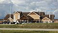
Pellston Regional Airport
-
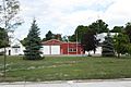
Fire department
-
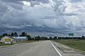
Sign on US 31
-
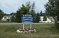
City welcome sign
-
Pellston Historical Society Museum


See also
 In Spanish: Pellston para niños
