
Ironwood, Michigan facts for kids
Quick facts for kids
Ironwood, Michigan
|
|
|---|---|
| City of Ironwood | |

Downtown along Aurora Street (Bus. US 2)
|
|

Location within Gogebic County
|
|

Ironwood, Michigan
Location in Michigan
|
|
| Country | United States |
| State | Michigan |
| County | Gogebic |
| Settled | 1885 |
| Incorporated | 1887 (village) 1889 (city) |
| Government | |
| • Type | City commission |
| Area | |
| • Total | 6.58 sq mi (17.04 km2) |
| • Land | 6.58 sq mi (17.04 km2) |
| • Water | 0.00 sq mi (0.00 km2) |
| Elevation | 1,506 ft (459 m) |
| Population
(2020)
|
|
| • Total | 5,045 |
| • Density | 766.95/sq mi (296.13/km2) |
| Time zone | UTC−6 (Central (CST)) |
| • Summer (DST) | UTC−5 (CDT) |
| ZIP code(s) |
49938
|
| Area code(s) | 906 |
| FIPS code | 26-41060 |
| GNIS feature ID | 0629087 |

Ironwood is a city in Gogebic County, located in the Upper Peninsula of Michigan. It's about 18 miles (29 km) south of Lake Superior. The city sits on US Highway 2, right across the Montreal River from Hurley, Wisconsin. It's the very westernmost city in Michigan.
In 2020, about 5,045 people lived in Ironwood. While it was once a big iron mining town, today it's famous for its downhill skiing resorts. These include Big Powderhorn, Black River, Snow River, Mount Zion, and Whitecap. You can also find great cross-country skiing at the Wolverine Nordic Trail System and the ABR Nordic Center.
Ironwood is also home to the "World's Tallest Indian." This is a 52-foot (16 m) tall fiberglass statue of the famous tribal leader Hiawatha.
Contents
History of Ironwood
Ironwood was first settled in the spring of 1885. It became a village in 1887 and then a city on April 8, 1889. The area north of the city became Ironwood Township on the same day.
In 1890, Ironwood's population grew to over 7,500 people. By 1900, it reached 10,000. The city is said to be named after James "Iron" Wood, a mining captain. He was honored by Frederic W. Rhinelander, who was the president of a railroad line.
Mining and Growth
Ironwood is located in what was once the Gogebic Iron Range. Iron ore was discovered here in the 1870s. When the railroad arrived in the mid-1880s, it helped the mining industry grow a lot. Many mines opened in Ironwood, such as the Norrie, Aurora, Ashland, Newport, and Pabst mines.
These mines and the lumber industry brought many new people to Ironwood. They came from other parts of the United States and from European countries. These included England, Finland, Germany, Italy, Poland, and Sweden.
Important Events
On September 17, 1887, a big fire destroyed half of the business area. However, the buildings were quickly rebuilt. In 1926, a sad event called the Pabst Mine Disaster happened. Three electricians died, and 43 miners were trapped underground for up to five days.
By the early 1890s, many different churches were built in Ironwood by the immigrant communities. These included:
- The Methodist Episcopal Church
- The Jessieville Methodist Episcopal Church
- St Ambrose Church (Catholic)
- St Michael's Church (Catholic)
- First Swedish Baptist Church
- Swedish Methodist Episcopal Church
- Swedish Mission Church (Covenant Church)
- Swedish Lutheran Church
- First Finnish Lutheran Church
- The First Presbyterian Church
- St Pauls Episcopal Church
- The First Apostolic Lutheran Church
Geography and Climate
Ironwood covers an area of about 6.42 square miles (16.63 square kilometers), and all of it is land. Ironwood is known for getting a lot of snow. It receives an average of 188.2 inches (4.78 m) of snow each winter. The most snow ever measured on the ground was 71 inches (1.8 m) on February 23, 1904.
Population and People
| Historical population | |||
|---|---|---|---|
| Census | Pop. | %± | |
| 1890 | 7,745 | — | |
| 1900 | 9,705 | 25.3% | |
| 1910 | 12,821 | 32.1% | |
| 1920 | 15,739 | 22.8% | |
| 1930 | 14,299 | −9.1% | |
| 1940 | 13,369 | −6.5% | |
| 1950 | 11,466 | −14.2% | |
| 1960 | 10,265 | −10.5% | |
| 1970 | 8,711 | −15.1% | |
| 1980 | 7,741 | −11.1% | |
| 1990 | 6,849 | −11.5% | |
| 2000 | 6,293 | −8.1% | |
| 2010 | 5,387 | −14.4% | |
| 2020 | 5,045 | −6.3% | |
| U.S. Decennial Census | |||
In 2010, there were 5,387 people living in Ironwood. Most of the people (96%) were White. About 1.1% were Native American, and 0.5% were African American.
The average age of people in the city was 45.5 years. About 19.3% of residents were under 18 years old.
Culture and Arts
Ironwood has two places for theater:
- Theatre North, which puts on live community plays.
- The Ironwood Theatre, which hosts local and national shows. It is also listed on the National Register of Historic Places.
Two dance companies, Bethany Ann Hellen Studios and Ironwood Dance Company, perform shows all year. They also send dancers to compete in state and national events. The Ironwood Carnegie Library is the oldest working Carnegie library in Michigan. In the summer, the Emberlight Festival brings musicians, Broadway stars, art shows, and independent films to Ironwood.
Ironwood in Books
Ironwood and its famous pasties (a type of pastry) are mentioned in Neil Gaiman's novel American Gods. The city is also important in the folk novel Marvin & Me by Rod Stockhaus, who grew up in Ironwood. Raymond Luczak's book Compassion, Michigan: The Ironwood Stories was inspired by Ironwood's long history.
Education


Ironwood has one high school, Luther L. Wright High School. It's often called Ironwood High School. Their mascot is the "Red Devils," a name that came from the iron ore miners who would get covered in red dust. The school has a long-standing sports rivalry with Hurley High School, which is in a different state.
Ironwood was also home to Ironwood Catholic High School, which closed in 1985. Sister Mary Aquinas Kinskey taught there before teaching aviation to members of the United States Armed Forces. The school's mascot was the ram, and the players were known as the "Ramblers."
Ironwood is also where Gogebic Community College is located.
Sports
Ironwood is the only place in Michigan's Upper Peninsula known to have hosted a professional sports team. The Gogebic Panthers played in the Northwest Football League in 1935 and 1936. In 1935, they had a great season with a 6–1 record.
Transportation

Highways
- US Highway 2 (US 2) goes west to Ashland, Wisconsin and Duluth, Minnesota. It goes east to Iron Mountain.
- Business US 2 serves the city of Ironwood.
- M-28 starts nearby in Wakefield and goes east across the Upper Peninsula of Michigan to Marquette and then to Sault Ste. Marie, Michigan.
- US 51 ends near Ironwood in Hurley, Wisconsin.
Bus and Air Travel
Indian Trails offers daily bus service between St. Ignace and Ironwood, and also between Ironwood and Duluth, Minnesota. Gogebic County also has a local public bus system called Gogebic County Transit (the LITTLE BLUE BUS).
Ironwood is served by the Gogebic-Iron County Airport (IWD). This airport has flights to Chicago O'Hare International Airport and Minneapolis-Saint Paul International Airport.
Trails
The Iron Belle Trail is a long hiking and biking trail that crosses Michigan. One end of this trail is in Ironwood.
Notable People
- Raymond Joseph Cannon: A U.S. Representative from Wisconsin and a lawyer.
- William S. Carlson: Was president of several universities, including the University of Delaware and the State University of New York.
- Agnes Charbonneau: A member of the Wisconsin State Assembly.
- Renee Louise (Jacisin) Ellmers: Served in the US House of Representatives for North Carolina.
- Jack Gotta: A Canadian Football League player, coach, and general manager.
- William C. Gribble Jr.: Was the Chief of Engineers for the US Army Corps of Engineers.
- John Regeczi: A football player who played with future president Gerald Ford at the University of Michigan.
Images for kids
-
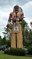
"World's Tallest Indian" statue
-
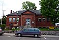
Ironwood Carnegie Library
-
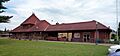
The Chicago and Northwestern Railroad Depot (now the Ironwood Historical Society)
-
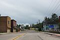
Entering Ironwood on Silver Street
See also
 In Spanish: Ironwood (Míchigan) para niños
