Sugar Island Township, Michigan facts for kids
Quick facts for kids
Sugar Island Township, Michigan
|
|
|---|---|

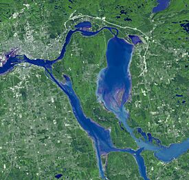
Satellite view of Sugar Island
|
|

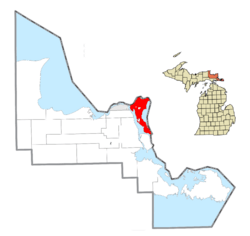
Location within Chippewa County
|
|
| Country | United States |
| State | Michigan |
| County | Chippewa |
| Established | 1857 |
| Area | |
| • Total | 76.46 sq mi (198.03 km2) |
| • Land | 49.35 sq mi (127.82 km2) |
| • Water | 27.11 sq mi (70.21 km2) |
| Elevation | 591 ft (180 m) |
| Population
(2020)
|
|
| • Total | 653 |
| • Density | 13.2/sq mi (5.1/km2) |
| Time zone | UTC-5 (EST) |
| • Summer (DST) | UTC-4 (EDT) |
| ZIP code(s) |
49783 (Sault Ste. Marie)
|
| Area code(s) | 906 |
| FIPS code | 26-77020 |
| GNIS feature ID | 1627131 |
Sugar Island Township is a special kind of local government area, called a civil township, located in Chippewa County in the state of Michigan. It's mostly made up of Sugar Island itself, along with some smaller islands and the water around them in the St. Marys River. In 2020, about 653 people lived here.
A big part of Sugar Island is also home to the Bay Mills Indian Community. This is a "federally recognized tribe," which means the U.S. government officially recognizes them as a Native American nation. The Bay Mills Indian Community is made up of the Ojibwe people, also known as Chippewa. They have lived in this area, including Sugar Island, for a very long time. About one-third of the island's population today are Native Americans.
Contents
Island History: The Ojibwe People
The Ojibwe people, often called Chippewa in the United States, have lived on Sugar Island and in nearby areas for at least 500 years. They have a rich history and culture connected to this land. The Bay Mills Indian Community is one of the important Ojibwe groups in Michigan, and their territory includes parts of Sugar Island. Their long history shows how important this island has been to their way of life.
Exploring Sugar Island's Geography
Sugar Island Township covers about 76 square miles (198 square kilometers). A little over half of this area, about 49 square miles (127 square kilometers), is land. The rest, about 27 square miles (70 square kilometers), is water.
The township is located just east of the city of Sault Ste. Marie, Michigan. You can get to Sugar Island from Sault Ste. Marie by taking a ferry across the water. On the other side of the St. Marys River, to the northwest, is Sault Ste. Marie, Ontario, in Canada. However, there isn't a direct way to travel between Sugar Island and the Canadian side.
Sugar Island Township is unique because it's one of only seven places in Michigan that are made up entirely of islands! Other island townships in Michigan include Grosse Ile Township, Drummond Township, Bois Blanc Township, Mackinac Island, Peaine Township, and St. James Township.
Life in Sugar Island Communities
- Homestead is a small, unincorporated community located on the southeastern part of Sugar Island. An "unincorporated community" means it's a group of homes or businesses that isn't officially a city or village with its own local government.
Population and People
In 2000, there were 683 people living in Sugar Island Township. By 2020, the population was 653. This shows that it's a small, close-knit community.
See also
 In Spanish: Municipio de Sugar Island para niños
 | Chris Smalls |
 | Fred Hampton |
 | Ralph Abernathy |


