Raber Township, Michigan facts for kids
Quick facts for kids
Raber Township, Michigan
|
|
|---|---|

Location within Chippewa County
|
|
| Country | United States |
| State | Michigan |
| County | Chippewa |
| Area | |
| • Total | 143.1 sq mi (370.6 km2) |
| • Land | 97.8 sq mi (253.3 km2) |
| • Water | 45.3 sq mi (117.3 km2) |
| Elevation | 600 ft (183 m) |
| Population
(2020)
|
|
| • Total | 632 |
| • Density | 4.417/sq mi (1.7053/km2) |
| Time zone | UTC-5 (Eastern (EST)) |
| • Summer (DST) | UTC-4 (EDT) |
| ZIP code(s) | |
| Area code(s) | 906 |
| FIPS code | 26-66760 |
| GNIS feature ID | 1626949 |
Raber Township is a special kind of local government area called a civil township. It is located in Chippewa County in the state of Michigan, United States. In 2020, about 632 people lived there.
Contents
Where is Raber Township?
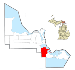
Raber Township is in the eastern part of Chippewa County. To its northeast, you'll find the St. Marys River. Across this river is St. Joseph Island in Ontario, Canada.
The southern edge of Raber Township is very close to the northern shore of Lake Huron. Large parts of the township, both in the north and south, are covered by the Lake Superior State Forest.
The United States Census Bureau says that Raber Township covers a total area of 143.1 square miles (370.6 km2). About 97.8 square miles (253.3 km2) of this is land, and 45.3 square miles (117.3 km2) is water. This means about 31.64% of the township is water!
The village of DeTour Village is to the southeast. The ZIP code for DeTour Village (49725) also serves the southeastern part of Raber Township. The town of Pickford is to the northwest, and its ZIP code (49774) covers the northwestern part of Raber Township.
Communities in Raber Township
Raber Township has several small communities. These are called "unincorporated communities" because they don't have their own separate local government like a city or village.
Goetzville
Goetzville is a community located on M-48. It's about 6 miles (10 km) north of M-134. The Goetz family first settled here in 1882.
A post office opened in October 1882, first called Gatesville. Its name was changed to Goetzville in February 1917. The Goetzville ZIP code (49736) serves the middle part of Raber Township. It also covers small areas in nearby Pickford Township and Detour Township.
Raber (Community)
The community of Raber is located on Raber Bay, which is part of the St. Marys River. It is about 2 miles (3.2 km) north-northeast of Goetzville.
The first European settler here was John Stevenson from Scotland in 1878. The community was named after Mueller M. Raber, who was an important lumberman in the area. Raber had its own post office from September 1889 until December 1954.
Stalwart
Stalwart is another community in the township, also on M-48. It's about 8 miles (13 km) west-northwest of Goetzville. Stalwart was first settled in 1878.
When people tried to open a post office here in 1881, they first wanted to name it "Garfield" after U.S. President James A. Garfield. But another post office already used that name. Then they tried "Arthur" after President Chester A. Arthur, but that name was also taken.
Since Presidents Garfield and Arthur were part of a political group called the "Stalwart" faction of the Republican Party, the post office was finally named "Stalwart." It opened in February 1881.
Population Information
In 2000, there were 670 people living in Raber Township. There were 310 households, with about 2.16 people per household. The median age of people living in the township was 50 years old.
See also
 In Spanish: Municipio de Raber (Míchigan) para niños
 | Victor J. Glover |
 | Yvonne Cagle |
 | Jeanette Epps |
 | Bernard A. Harris Jr. |


