
Whitefish Township, Michigan facts for kids
Quick facts for kids
Whitefish Township, Michigan
|
|
|---|---|

Township Community Center in Paradise
|
|

Location within Chippewa County
|
|

Whitefish Township, Michigan
Location in Michigan

Whitefish Township, Michigan
Location in the United States
|
|
| Country | United States |
| State | Michigan |
| County | Chippewa |
| Organized | 1888 |
| Area | |
| • Total | 293.64 sq mi (760.5 km2) |
| • Land | 241.50 sq mi (625.5 km2) |
| • Water | 20.13 sq mi (52.14 km2) |
| Elevation | 686 ft (209 m) |
| Population
(2020)
|
|
| • Total | 474 |
| • Density | 1.96/sq mi (0.76/km2) |
| Time zone | UTC-5 (Eastern (EST)) |
| • Summer (DST) | UTC-4 (EDT) |
| ZIP code(s) | |
| Area code(s) | 906 |
| FIPS code | 26-86700 |
| GNIS feature ID | 1627260 |
| Whitefish Township Informational Designation |
|
|---|---|
 |
|
| Location | 7052 M-123 Paradise, Michigan 49768 |
| Designated | March 15, 1990 |
Whitefish Township is a special kind of local government area called a civil township. It is located in Chippewa County in the state of Michigan, USA. In 2020, about 474 people lived there.
Whitefish Township is quite large, covering about 241.50 square miles of land. This makes it the sixth-largest local government area in Michigan by land size. Even though it's big, not many people live there, so it's very spread out. The township is right on Whitefish Bay, which is part of Lake Superior. It's home to the famous Whitefish Point Light (a lighthouse) and the Great Lakes Shipwreck Museum. You can also find parts of Tahquamenon Falls State Park here.
Contents
Exploring Whitefish Township
Whitefish Township is in the northwest corner of Chippewa County. It's part of Michigan's Upper Peninsula. To the north, it touches the huge Lake Superior, and to the east, it borders Whitefish Bay.
What Makes Whitefish Township Special?
The northernmost tip of the township is called Whitefish Point. Another important spot is Vermilion Point to the west. Nearby townships include Bay Mills, Chippewa, and Hulbert to the south and southeast. To the west, it borders McMillan Township in Luce County.
The Tahquamenon River flows through the township and empties into Lake Superior here. A big part of Tahquamenon Falls State Park is within Whitefish Township. This includes the beautiful Lower Tahquamenon Falls. A smaller part of the park stretches into McMillan Township.
Whitefish Township is also home to:
- The Whitefish Point Light, a historic lighthouse.
- The Great Lakes Shipwreck Museum, where you can learn about shipwrecks on the Great Lakes.
- The Whitefish Point Bird Observatory, a place where scientists study birds.
- A part of the Seney National Wildlife Refuge, which protects wildlife.
Roads and Travel
- M-123 is a main road that goes from south to north through the township. It then turns east when it reaches the community of Paradise.
- The Whitefish Bay National Forest Scenic Byway (also known as Lake Superior Shoreline Road) briefly enters the southern part of the township. It ends when it meets M-123.
Small Towns and Places
Whitefish Township has several small communities, some of which are no longer inhabited.
- Emerson is a community that is no longer lived in.
- Paradise is a small community located along M-123. It sits right on the shores of Whitefish Bay. The ZIP Code for Paradise (49768) covers most of Whitefish Township.
- Shelldrake is another small community within the township.
- Snug Harbor is a community located along the Tahquamenon River.
- Timberlost is also a community found along the Tahquamenon River.
- Vermilion is a community in the northern part of the township near Vermilion Point. It is no longer inhabited. This remote area was once home to the Vermilion Lifesaving Station, which started in 1877. A small community grew around it, mainly for the station's workers and their families. A post office operated here from 1896 to 1922. When the station closed in 1944, the community was left empty. Today, only one original building remains, along with a few that have been fixed up.
- Whitefish Landing is a community located along the Tahquamenon River, just upstream from Timberlost.
- Whitefish Point is a community at the very northern end of the township, close to Whitefish Point. This is where you'll find the Great Lakes Shipwreck Museum, the Whitefish Point Bird Observatory, and the Whitefish Point Light. This community was settled in 1871. It had its own post office from 1877 to 1974. Even though the post office is closed now, the area was recognized as a Michigan State Historic Site in 1979.
Population Facts
In the year 2000, there were 588 people living in Whitefish Township. By the 2020 census, the population had changed to 474 people.
Images for kids
-
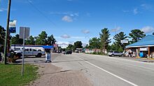
The community of Paradise
-
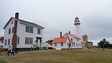
The historic Whitefish Point Light
-
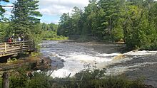
The beautiful Lower Tahquamenon Falls


See also
 In Spanish: Municipio de Whitefish para niños
