
McMillan Township, Luce County, Michigan facts for kids
Quick facts for kids
McMillan Township, Michigan
|
|
|---|---|
_office.jpg)
McMillan Township Hall in Newberry
|
|
,_MI_location2.png)
Location within Luce County (red) and the administered village of Newberry (pink)
|
|

McMillan Township, Luce County, Michigan
Location in Michigan

McMillan Township, Luce County, Michigan
Location in the United States
|
|
| Country | United States |
| State | Michigan |
| County | Luce |
| Established | 1920 |
| Area | |
| • Total | 604.35 sq mi (1,565.26 km2) |
| • Land | 588.78 sq mi (1,524.93 km2) |
| • Water | 15.57 sq mi (40.33 km2) |
| Elevation | 804 ft (245 m) |
| Population
(2020)
|
|
| • Total | 2,471 |
| • Density | 4.20/sq mi (1.62/km2) |
| Time zone | UTC-5 (Eastern (EST)) |
| • Summer (DST) | UTC-4 (EDT) |
| ZIP code(s) | |
| Area code(s) | 906 |
| FIPS code | 26-50440 |
| GNIS feature ID | 1626658 |
McMillan Township is a large area in Luce County, Michigan. It's like a big neighborhood or district. In 2020, about 2,471 people lived here. McMillan Township is the biggest local government area in Michigan by land size. It covers over 588 square miles!
This township makes up a big part of Luce County. It also includes the village of Newberry. Newberry is the main town and the only official village in the county. McMillan Township is home to two cool state parks: Muskallonge Lake State Park and part of Tahquamenon Falls State Park. You can also find the Upper Tahquamenon Falls here. Plus, the historic Crisp Point Light lighthouse is in the northeast part of the township.
Contents
Exploring McMillan Township's Land
McMillan Township is very large. It covers about 604 square miles in total. Most of this area is land, around 588 square miles. The rest, about 15 square miles, is water.
The township has a long shoreline along Lake Superior. It also has many other lakes and rivers. Some of these include the Blind Sucker River, Carp River, Little Two Hearted River, Tahquamenon River, and Two Hearted River. You can also find Muskallonge Lake here. The famous North Country Trail also runs through the township, offering great hiking.
Main Roads in the Township
 M-123 is a main road that goes north and south. It runs through the middle-south part of the township.
 H-58 is also called Deer Park Road. It follows the shore of Lake Superior. This road connects to Pictured Rocks, a beautiful natural area.
Towns and Places to See
McMillan Township has several small communities and interesting spots:
- Betty B Landing is a small community by the Tahquamenon River. It's known for the Toonerville Trolley Riverboat Tour. This tour uses a special narrow-gauge railroad. It was once a lumber company's private railway.
- Deer Park is another small community.
- Dollarville is a community just west of Newberry.
- Eightmile Corner is a small community along H-37 in the western part of the township.
- Fourmile Corner is a community where H-37 and M-123 meet. It's about 4 miles north of Newberry.
- Hunter's Mill used to be a place where lumber was processed. It's located between Newberry and Soo Junction.
- Newberry is the main village in the area. It's centered along M-123.
- Lencel is a small community along the railway line, east of Newberry.
- McPhees Landing is another community located along the Tahquamenon River.
- Natalie is a small community along the railway line, west of Dollarville.
- Pine Stump Junction is a community along Deer Park Road. It's between Deer Park and Newberry.
- Soo Junction is a community east of Newberry. It got its name because it was a railway junction. It even had its own post office for many years.
Who Lives in McMillan Township?
In 2020, the population of McMillan Township was 2,471 people. In 2010, there were 2,692 people living here. About 82.2% of the people were White, and 6.2% were Native American. A small percentage were African American or Asian. About 1.6% of the population was Hispanic or Latino.
In 2010, there were 1,193 households. About 24.1% of these households had children under 18 living with them. Many households were families, with married couples or single parents.
Gallery
-
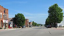
Village of Newberry along M-123 -
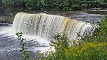
Upper Tahquamenon Falls
.jpg)
.jpg)
.jpg)

See also
 In Spanish: Municipio de McMillan (condado de Luce) para niños
