
Pictured Rocks National Lakeshore facts for kids
Quick facts for kids Pictured Rocks National Lakeshore |
|
|---|---|
|
IUCN Category III (Natural Monument)
|
|

Bridalveil Falls emptying into Lake Superior
|
|
| Location | Alger County, Michigan, United States |
| Nearest city | Munising, Michigan |
| Area | 73,236 acres (296.38 km2) |
| Established | October 15, 1966 |
| Visitors | 953,052 (in 2024) |
| Governing body | National Park Service |
| Website | Pictured Rocks National Lakeshore |
| Official name: Pictured Rocks | |
| Designated: | February 17, 1965 |


Pictured Rocks National Lakeshore is a super cool place in the Upper Peninsula of Michigan, United States. It stretches for about 42 miles (67 km) along the shore of Lake Superior. This special park covers a huge area of 73,236 acres (296.37 km²).
You'll find amazing views of hills, colorful rock formations, beautiful waterfalls, and sandy dunes here. The park is located between the towns of Munising and Grand Marais in Alger County.
The name "Pictured Rocks" comes from 13 miles (24 km) of bright, colorful sandstone cliffs. These cliffs are northeast of Munising and can reach up to 200 feet (60 m) tall! Over time, nature has carved them into shallow caves, arches, and shapes that look like castle towers or even human faces. Near Munising, you can also visit Grand Island, which is mostly part of another park called Grand Island National Recreation Area.
Pictured Rocks was the very first National Lakeshore in the United States. It was created by the U.S. Congress in 1966. The National Park Service (NPS) takes care of it. In 2021, over 1.3 million people visited this amazing place!
Contents
How Pictured Rocks Were Formed

The stunning colors you see in the cliffs come from many different minerals in the rock. These cliffs are made of sandstone that is about 500 million years old! This rock layer is called the Munising Formation.
Below the Munising Formation, there's an even older rock layer called the Jacobsville Formation. This reddish rock is the oldest in the park. On top of the Munising Formation, there's a hard sandstone layer called the Au Train Formation.
The colorful streaks on the cliffs happen when groundwater seeps out of the rock and dries up. It leaves behind streaks of iron (which makes red colors), manganese (black-white), limonite (yellow-brown), copper (pink-green), and other minerals.
A Look Back in Time

The waters around Pictured Rocks were great for fishing, but the cliffs were dangerous for small boats. In 1658, a fur trader named Pierre Esprit Radisson traveled here. He wrote that his Native American friends offered tobacco to the spirits of the cliffs for a safe journey.
Later, in the 1800s, many American writers shared their feelings about the Pictured Rocks. Geologist Henry Rowe Schoolcraft visited in 1820. He said the views were "some of the most sublime and commanding views in nature."
Around 1850, people even planned to build a tourist resort called Grand Island City near the Pictured Rocks.
After the logging industry ended around 1910, much of the land became state property. Michigan worked with the federal government to protect the area. In October 1966, a law was passed to create the Pictured Rocks National Lakeshore. The goal was to "preserve for the benefit, inspiration, education, recreational use, and enjoyment of the public, a significant portion of the diminishing shoreline of the United States." This made it America's very first National Lakeshore!
On April 13, 2006, something big happened: part of a famous rock formation called Miner's Castle collapsed. Fishermen in the area reported it by cell phone. The rocks here are crumbly sandstone, and rockfalls often happen in spring and fall due to freezing and thawing.
In 2009, a law was signed that protected 11,740 acres (47.5 km²) of Pictured Rocks as the Beaver Basin Wilderness. This wilderness area covers 13 miles of the shoreline.
Getting to Pictured Rocks

You can reach Munising, on the west side of the lakeshore, by taking highways M-28 and M-94. Grand Marais, on the east side, is reached by M-77.
Paved roads go into the Lakeshore from both ends, connected by County Road H-58. Roads get close to the shore only near Miners Castle, 12 Mile Beach, and the Grand Sable Dunes. To see the rest of the shoreline from land, you'll need to hike!
A 42-mile (67 km) section of the North Country Trail runs through the lakeshore. If you want to camp in the backcountry, you'll need a permit.
Many boat companies offer daily trips along the lakeshore from late May through the fall. Sea kayaking is another popular way to explore the park. It's a great way to see the rock formations up close, but the water can be cold and dangerous. It's best to go with proper gear or a guide. You can rent pontoons locally too.
In winter, people enjoy cross-country skiing, snowshoeing, snowmobiling, ice climbing, and ice fishing.
Places to See


Here are some cool spots to check out, from west (Munising) to east (Grand Marais):
- Munising Falls, with its visitor center.
- Sand Point, where the National Lakeshore Headquarters is located.
- Munising Coast Guard Station Boathouse Museum.
- Miners Castle rock formation, which has a paved road to an overlook.
- Miners River, flowing into Lake Superior near Miners Beach.
- Miners Falls interpretive trail.
- Grand Portal Point rock formations.
- Mosquito Falls.
- Mosquito River.
- Chapel Rock.
- Chapel Falls.
- Beaver Basin Wilderness.
- Twelvemile Beach.
- Shipwrecks.
- White Birch Forest.
- Au Sable Point, home to the Au Sable Light lighthouse.
- Log Slide.
- Grand Sable Dunes.
- Grand Sable Lake.
- Sable Falls, with its visitor center.
Amazing Waterfalls


Pictured Rocks has many beautiful waterfalls! Most of them are formed by water flowing over the cliffs of the Munising Formation. Remember, pets are not allowed on most of the trails.
- Munising Falls is a 50-foot (15 m) waterfall over a sandstone cliff. The trail is easy to access for everyone, and dogs are allowed.
- Miners Falls has a self-guided trail. There are 77 steps down to a viewing platform. The falls drops 50 feet (15 m) over sandstone.
- Bridalveil Falls is a seasonal waterfall. In summer, it might just be a small trickle.
- Mosquito Falls drops 8 feet (2.4 m) over a rock shelf on the Mosquito River. You might even spot river otters or beavers here!
- Chapel Falls cascades about 60 feet (18 m) down sandstone cliffs.
- Spray Falls is best seen from Lake Superior. An old shipwreck from 1856, the Superior, lies at the bottom of the falls in 20 feet (6 m) of water.
- Sable Falls tumbles 75 feet (23 m) over several cliffs of sandstone on its way to Lake Superior.
Grand Sable Dunes
The Grand Sable Dunes are at the eastern end of the Lakeshore. These are "perched dunes," meaning sand was blown up from the lake by strong winds and piled on top of a hill left by glaciers.
Today, the Grand Sable Dunes form a five-mile-long sand slope that rises from Lake Superior at a steep 35-degree angle. The tallest dunes are as high as 275 feet (85 m) above the lake!
Long ago, loggers built a wooden slide from the top of the dunes down to Lake Superior to move timber. This spot is now popular for viewing the dunes and climbing on them. You can also find a trail from the Grand Sable Visitors Center.
Fun Things to Do
.jpg)
Pictured Rocks National Lakeshore offers lots of fun activities all year round! You can go hiking, back-country camping, kayaking, boating, swimming, scuba diving, and fishing. In winter, there's snowmobiling, ice climbing, and cross-country skiing. The amazing scenery and many activities attract many visitors, with a record 800,000 people visiting in 2018.
Boating and Kayaking Adventures
The colorful rock formations are a big draw for kayakers and boat tours in the summer. People love to see the unique rock shapes and colors up close. If you want to kayak near the cliffs, it's important to have special sea-kayaking gear and know-how, as the water can be dangerous.
Exploring Underwater
Pictured Rocks National Lakeshore is also a popular spot for scuba diving! The rough waters of Lake Superior have caused many shipwrecks over the years, which divers love to explore. A popular diving area is the Alger Underwater Preserve.
Winter Wonderland Sports

Thanks to "lake-effect snow" (snow caused by cold air moving over warm lake water), Pictured Rocks and the Munising area get a lot of snow! This makes it perfect for snowmobilers, with special trails just for them and for cross-country skiing.
The long, cold winters and constant runoff from melting snow also create some of the best ice-climbing spots in the country. There are over 50 named ice formations! Ice climbing here attracts people from all over. Even if you don't climb, the ice formations are cool to see.
Weather at Pictured Rocks
| Climate data for Grand Marais, Michigan | |||||||||||||
|---|---|---|---|---|---|---|---|---|---|---|---|---|---|
| Month | Jan | Feb | Mar | Apr | May | Jun | Jul | Aug | Sep | Oct | Nov | Dec | Year |
| Mean daily maximum °F | 25.3 | 27.4 | 36.4 | 49.2 | 62.1 | 70.4 | 75.9 | 74.8 | 67 | 55.8 | 41.5 | 29.7 | 51.3 |
| Mean daily minimum °F | 11.2 | 10.6 | 17.9 | 29.3 | 37.9 | 45.7 | 51.9 | 52.8 | 47.1 | 38 | 28.2 | 17 | 32.3 |
| Average rainfall inches | 2.3 | 1.4 | 1.6 | 1.6 | 2.5 | 2.9 | 2.5 | 3.2 | 3.6 | 3 | 2.6 | 2.5 | 29.8 |
| Average snowfall inches | 47.3 | 30.7 | 16 | 4.8 | 0.3 | 0.0 | 0.0 | 0.0 | 0.0 | 0.9 | 12.6 | 41.7 | 154.2 |
| Mean daily maximum °C | −3.7 | −2.6 | 2.4 | 9.6 | 16.7 | 21.3 | 24.4 | 23.8 | 19 | 13.2 | 5.3 | −1.3 | 10.7 |
| Mean daily minimum °C | −11.6 | −11.9 | −7.8 | −1.5 | 3.3 | 7.6 | 11.1 | 11.6 | 8.4 | 3 | −2.1 | −8 | 0.2 |
| Average rainfall mm | 58 | 36 | 41 | 41 | 64 | 74 | 64 | 81 | 91 | 76 | 66 | 64 | 760 |
| Average snowfall cm | 120 | 78 | 41 | 12 | 0.76 | 0.0 | 0.0 | 0.0 | 0.0 | 2.3 | 32 | 106 | 392 |
|
||||||||||||||||||||||||||||||||||||||||||||||||||||||||||||||||||||||||||||||||||||||||||||||||
Images for kids
-
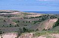
View of the dunes with Lake Superior in the background
-
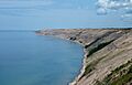
A view of the Grand Sable Banks looking east from the logslide location
-
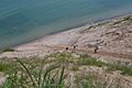
A view of the former logslide site from the top of the banks
-
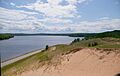
A view of the dunes overlooking Grand Sable Lake


