Sable Falls facts for kids
Quick facts for kids Sable Falls |
|
|---|---|

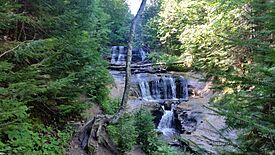
View of Sable Falls from downstream
|
|
| Lua error in Module:Infobox_mapframe at line 185: attempt to index field 'wikibase' (a nil value). | |
| Location | Pictured Rocks National Lakeshore Burt Township, Michigan |
| Coordinates | 46°40′08″N 86°00′48″W / 46.66889°N 86.01333°W |
| Total height | 75 feet (22.9 m) |
| Watercourse | Sable Creek |
Sable Falls is a beautiful waterfall found in the Pictured Rocks National Lakeshore in Alger County, Michigan. It's a popular spot for visitors who want to see nature's power and beauty. The falls are about 75 feet (23 meters) tall, making them quite impressive!
What is Sable Falls?
Sable Falls is a waterfall on a stream called Sable Creek. This creek flows into Lake Superior, one of the Great Lakes. The water tumbles down over different kinds of rock, mostly Munising and Jacobsville sandstone. These rocks have been shaped by the water over many, many years.
The waterfall is not far from Lake Superior, only about half a mile away. This makes it a great stop if you are exploring the Pictured Rocks area.
Visiting Sable Falls
Getting to Sable Falls is quite easy. You can reach it by taking H-58, a road west of a town called Grand Marais, Michigan. Once you arrive, you'll find stairs that lead down to the falls.
- Stairs and Boardwalk: To see the falls up close, you'll walk down a set of stairs. These stairs lead to a boardwalk. This boardwalk was made longer between 2007 and 2010. It now lets you explore more of Sable Creek. You can see not just the main, upper falls, but also smaller falls and rapids downstream.
- Accessibility: It's important to know that the area around Sable Falls is not set up for wheelchairs or people with limited mobility. The stairs make it a bit challenging to access for some visitors.
Sable Falls is a wonderful place to visit if you love nature and want to see a powerful waterfall in a beautiful setting.
 | May Edward Chinn |
 | Rebecca Cole |
 | Alexa Canady |
 | Dorothy Lavinia Brown |


