Bridalveil Falls (Michigan) facts for kids
Quick facts for kids Bridalveil Falls |
|
|---|---|

Bridalveil Falls, Michigan
|
|
| Lua error in Module:Infobox_mapframe at line 185: attempt to index field 'wikibase' (a nil value). | |
| Location | Alger County, Michigan, United States |
| Coordinates | Maps 46°30′30″N 86°31′23″W / 46.50833°N 86.52306°W |
| Type | Plunge Horsetail |
| Total height | 140 feet (43 m) |
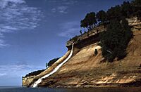
Bridalveil Falls is a beautiful waterfall located in Pictured Rocks National Lakeshore, Michigan. It's known as a seasonal waterfall, which means it doesn't flow all year round. Instead, it's most active during certain times, like in the spring when snow melts or after heavy rains.
This amazing waterfall drops about 140 feet (43 m) (that's like a 14-story building!). It's a type of waterfall called a plunge horsetail, which describes how the water falls almost vertically and spreads out a bit, looking a bit like a horse's tail.
Where to Find Bridalveil Falls
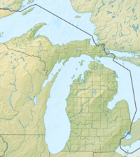
Bridalveil Falls is located in Alger County, Michigan, within the stunning Pictured Rocks National Lakeshore. This national lakeshore is famous for its colorful sandstone cliffs, clear blue waters of Lake Superior, and many other waterfalls.
To get a glimpse of Bridalveil Falls, you can follow these directions:
- From Munising, drive east on H-58 for about 4.5 miles (7.2 km).
- Then, turn onto Miners Castle Road and continue for about 5 miles (8.0 km) until you reach Miners Castle.
How to See the Falls
You can see Bridalveil Falls from a distance from Miners Castle. This spot offers a great overview of the area.
For different views, you have a few options:
- From the Lake: Many people choose to see the falls from a boat tour on Lake Superior. This often provides the best and closest views of the waterfall and the surrounding cliffs.
- Hiking: You can also hike on the Lakeshore Trail. However, from the trail itself, you'll mostly get partial views of the falls from a distance.
Bridalveil Falls is a wonderful natural sight, especially when it's flowing strongly. It's a great spot to visit if you're exploring the Pictured Rocks National Lakeshore!
 | Percy Lavon Julian |
 | Katherine Johnson |
 | George Washington Carver |
 | Annie Easley |


