
Munising, Michigan facts for kids
Quick facts for kids
Munising, Michigan
|
|
|---|---|
| City of Munising | |
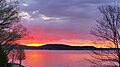
.jpg)
View of the downtown area from Munising Harbor
|
|
| Motto(s):
Gateway to Adventure
|
|

Location within Alger County
|
|

Munising, Michigan
Location in Michigan

Munising, Michigan
Location in the United States
|
|
| Country | |
| State | |
| County | |
| Settled | 1855 |
| Incorporated | 1896 (village) 1915 (city) |
| Government | |
| • Type | City commission |
| Area | |
| • Total | 9.04 sq mi (23.41 km2) |
| • Land | 5.26 sq mi (13.62 km2) |
| • Water | 3.78 sq mi (9.79 km2) |
| Elevation | 614 ft (187 m) |
| Population
(2020)
|
|
| • Total | 1,986 |
| • Density | 377.71/sq mi (145.84/km2) |
| Time zone | UTC-5 (Eastern (EST)) |
| • Summer (DST) | UTC-4 (EDT) |
| ZIP code(s) |
49862
|
| Area code(s) | 906 |
| FIPS code | 26-56200 |
| GNIS feature ID | 1620952 |
Munising (pronounced MEW-nə-sing) is a small city in the Upper Peninsula of Michigan, USA. It is home to 1,986 people, based on the 2020 census. This makes it the 17th largest city in the Upper Peninsula.
Munising is the main city in Alger County. It sits on the southern shore of Lake Superior. The city is known as the western entrance to the beautiful Pictured Rocks National Lakeshore.
Contents
Exploring Munising's Past
The name "Munising" comes from the Ojibwe word minisiing. This word means "at the island," likely referring to nearby Grand Island.
A post office was first set up here on December 22, 1868. Later, in 1889, it was briefly renamed Gogarnville. This was in honor of Julius Gogarn, who was the postmaster and a Civil War veteran. The name Munising was brought back in 1893.
Discovering Munising's Geography
Munising is located on the southern edge of Munising Bay. This bay is also called the South Bay of Grand Island Harbor. It's right across from Grand Island. The Anna River flows into the bay here.
The city is a starting point for boat trips to Pictured Rocks National Lakeshore. It is also a gateway to Grand Island National Recreation Area. Grand Island is only about half a mile north in Munising Bay.
Munising covers about 9 square miles (23.41 square kilometers). A good portion of this area is water, thanks to the bay.
Waterfalls Around Munising
The area around Munising is famous for its many stunning waterfalls. Some of these include:
- Alger Falls
- Horseshoe Falls
- Memorial Falls
- Munising Falls
- Miners Falls
- Scott Falls
- Tannery Falls
- Wagner Falls
Munising's Climate and Weather
Munising has a climate with warm summers and very cold winters. It gets a lot of snow, especially "lake-effect snow." This happens when cold air moves over the warmer waters of Lake Superior.
| Climate data for Munising, Michigan (1991–2020 normals, extremes 1911–present) | |||||||||||||
|---|---|---|---|---|---|---|---|---|---|---|---|---|---|
| Month | Jan | Feb | Mar | Apr | May | Jun | Jul | Aug | Sep | Oct | Nov | Dec | Year |
| Record high °F (°C) | 58 (14) |
57 (14) |
82 (28) |
89 (32) |
95 (35) |
97 (36) |
103 (39) |
103 (39) |
99 (37) |
87 (31) |
70 (21) |
60 (16) |
103 (39) |
| Mean daily maximum °F (°C) | 23.4 (−4.8) |
25.3 (−3.7) |
33.4 (0.8) |
44.6 (7.0) |
58.6 (14.8) |
67.6 (19.8) |
72.7 (22.6) |
72.0 (22.2) |
64.6 (18.1) |
51.6 (10.9) |
39.1 (3.9) |
29.0 (−1.7) |
48.5 (9.2) |
| Daily mean °F (°C) | 17.4 (−8.1) |
18.4 (−7.6) |
26.2 (−3.2) |
36.6 (2.6) |
48.9 (9.4) |
58.3 (14.6) |
64.1 (17.8) |
63.4 (17.4) |
56.7 (13.7) |
44.6 (7.0) |
33.3 (0.7) |
23.5 (−4.7) |
40.9 (4.9) |
| Mean daily minimum °F (°C) | 11.4 (−11.4) |
11.5 (−11.4) |
19.0 (−7.2) |
28.5 (−1.9) |
39.1 (3.9) |
49.0 (9.4) |
55.4 (13.0) |
54.8 (12.7) |
48.7 (9.3) |
37.7 (3.2) |
27.5 (−2.5) |
17.9 (−7.8) |
33.4 (0.8) |
| Record low °F (°C) | −27 (−33) |
−33 (−36) |
−26 (−32) |
−15 (−26) |
10 (−12) |
21 (−6) |
31 (−1) |
24 (−4) |
22 (−6) |
4 (−16) |
−10 (−23) |
−21 (−29) |
−33 (−36) |
| Average precipitation inches (mm) | 3.54 (90) |
2.38 (60) |
2.01 (51) |
2.94 (75) |
3.08 (78) |
3.23 (82) |
3.44 (87) |
3.15 (80) |
4.24 (108) |
4.93 (125) |
3.47 (88) |
3.44 (87) |
39.85 (1,012) |
| Average snowfall inches (cm) | 46.0 (117) |
32.4 (82) |
17.9 (45) |
9.6 (24) |
0.0 (0.0) |
0.0 (0.0) |
0.0 (0.0) |
0.0 (0.0) |
0.0 (0.0) |
1.1 (2.8) |
14.9 (38) |
39.1 (99) |
161.0 (409) |
| Average precipitation days (≥ 0.01 in) | 22.0 | 16.8 | 12.4 | 11.4 | 12.5 | 11.7 | 11.9 | 10.3 | 14.2 | 17.6 | 16.5 | 18.7 | 176.0 |
| Average snowy days (≥ 0.1 in) | 21.4 | 16.0 | 9.0 | 3.5 | 0.2 | 0.0 | 0.0 | 0.0 | 0.0 | 1.3 | 8.1 | 16.2 | 75.7 |
| Source: NOAA | |||||||||||||
Munising's Population Over Time
| Historical population | |||
|---|---|---|---|
| Census | Pop. | %± | |
| 1880 | 135 | — | |
| 1900 | 2,014 | — | |
| 1910 | 2,952 | 46.6% | |
| 1920 | 5,037 | 70.6% | |
| 1930 | 3,956 | −21.5% | |
| 1940 | 4,409 | 11.5% | |
| 1950 | 4,339 | −1.6% | |
| 1960 | 4,228 | −2.6% | |
| 1970 | 3,677 | −13.0% | |
| 1980 | 3,083 | −16.2% | |
| 1990 | 2,783 | −9.7% | |
| 2000 | 2,539 | −8.8% | |
| 2010 | 2,355 | −7.2% | |
| 2020 | 1,986 | −15.7% | |
| U.S. Decennial Census | |||
In 2010, Munising had 2,355 people living in 1,032 households. About 4.8% of the people were Native American. Most of the population, 91.2%, was White.
The average age in the city in 2010 was about 48.6 years old.
Getting Around Munising
Several important roads help people travel in and out of Munising:
 M-28 goes west to Marquette and east to Sault Ste. Marie.
 M-94 travels west through Chatham. It also goes south to Manistique.
 H-11 connects to Miner's Castle inside Pictured Rocks National Lakeshore.
 H-13 is a north-south road that ends in the eastern part of the city.
 H-58 starts in downtown Munising and goes northeast through Pictured Rocks National Lakeshore.
Famous People from Munising
Many interesting people have come from Munising, including:
- Connie Binsfeld, who was a Lieutenant Governor of Michigan.
- George Snow Hill, a well-known painter.
- Steven J. Raica, a Roman Catholic priest and bishop.
- Brock Strom, a professional football player.
- James Wickstrom, a radio talk show host.
- Arthur DeLacy Wood, who chaired a parole board.
Gallery
-
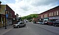
Downtown Munising (Elm Avenue)
-
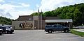
Alger County Courthouse Complex
-
Munising Harbor
-
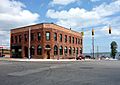
Munising City Hall
-
A storm across Munising Bay, seen from the east side


See also
 In Spanish: Munising (Míchigan) para niños
