Au Sable Light facts for kids
 |
|
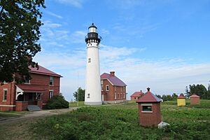
| Au Sable Light complex in June 2021 | |
| Location | Pictured Rocks National Lakeshore on Lake Superior |
|---|---|
| Coordinates | 46°40′23″N 86°08′21.6″W / 46.67306°N 86.139333°W |
| Year first constructed | 1874 |
| Year first lit | 1874 |
| Automated | 1958 |
| Foundation | Wood pilings |
| Construction | Brick, Italianate bracketing |
| Tower shape | Frustum of a cone |
| Markings / pattern | White with black lantern |
| Height | 87 feet (27 m) |
| Focal height | 107 feet (33 m) |
| Original lens | Third-order Fresnel lens (original), 12-inch (300 mm) acrylic (current) |
| Range | 11 nautical miles (20 km; 13 mi) |
| Characteristic | Flashing white every 6 s |
The Au Sable Light is an active lighthouse located in the Pictured Rocks National Lakeshore. It stands west of Grand Marais, Michigan, right off H-58. This important aid to navigation helps ships find their way. Before 1910, it was known as "Big Sable Light." It's important not to confuse it with other lighthouses like Big Sable Point Light or Little Sable Point Light.
Contents
History of Au Sable Light
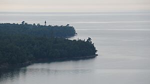
The Au Sable Light Station was built in 1874. It stands on Au Sable Point, a very dangerous spot on Lake Superior. This area was known as the "shipwreck coast."
Why the Lighthouse Was Needed
Au Sable Point has a hidden danger: a shallow ridge of sandstone. This reef is only about 6 feet (1.8 meters) below the water's surface in some places. It stretches almost a mile (1.6 km) into Lake Superior.
In the early days of shipping, captains often stayed close to land to navigate. This made the Au Sable Point reef a huge risk. Many ships got stuck there, including the passenger ship Lady Elgin in 1859.
The shoreline here is beautiful, but it was very deadly in the 1800s. Unpredictable underwater features, strong storms, and thick fogs made it dangerous. French explorers even called the region "most dangerous when there is any storms" as early as 1622.
The lighthouse was also built to fill a "dark spot" in the shipping route. This was an 80-mile (129 km) stretch between Granite Island Light and Whitefish Point Light that had no guiding light.
Who Designed the Lighthouse?
Colonel Orlando Metcalfe Poe designed the Au Sable Light. He was a District Engineer for the Eleventh Lighthouse District. He designed eight lighthouses, often called "Poe style lighthouses."
Some of his other famous designs include New Presque Isle Light on Lake Huron and South Manitou Island Light on Lake Michigan. He also designed Grosse Point Light in Illinois and Wind Point Light in Wisconsin.
Lighthouse Features and Changes Over Time
The Au Sable Light tower is made of white brick and shaped like a cone. It has a black lantern room at the top. Next to the tower is a red brick house where the lighthouse keepers lived.
Originally, the lighthouse used a special Fresnel lens to focus its light. This lens is now on display at the light station. In 1958, the lighthouse became automated, meaning it no longer needed a keeper to operate it. Today, it uses a modern, solar-powered light.
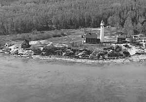
Over the years, other buildings were added to the light station. A wooden boathouse was built in 1875. A building for the fog signal was added in 1897. The keepers' house was made into a duplex (two separate living spaces) in 1909. A steel oil house was built in 1915 to store fuel.
Other buildings included a second brick keepers' house, a kerosene storage shed, and two brick outhouses. There was also a wooden woodshed and a two-vehicle garage. Most of these buildings are still standing today.
The Lighthouse Today
The keeper's house has been updated. The lower floor now serves as a visitor center for guests. The upper floor is an apartment for volunteers who help take care of the lighthouse.
In 1996, the original Fresnel lens was brought back to the tower. It had been on display at the Grand Marais Maritime Museum for 39 years. While the original lens is there, a modern 300mm lens is currently used to operate the light.
The old steam whistle and airhorn that once warned ships have been removed. However, the lighthouse tower is still an impressive sight.
The lighthouse tower is open to the public during the summer months. The National Park Service maintains the complex. The United States Coast Guard continues to operate the automated light. The National Park Service aims to keep the lighthouse complex looking as it did in 1909–10. This was when it first operated as a station with two lighthouse keepers.
The Au Sable Light Station is part of the National Park Service's Pictured Rocks National Lakeshore. It is also listed on the National Register of Historic Places.
How to Visit Au Sable Light
To visit this historic lighthouse, take ![]() H-58 from the Hurricane River Campground. This campground is about 12 miles (19 km) west of Grand Marais, Michigan. From the campground, it's a 1.5-mile (2.4 km) walk on a sand trail to reach the lighthouse.
H-58 from the Hurricane River Campground. This campground is about 12 miles (19 km) west of Grand Marais, Michigan. From the campground, it's a 1.5-mile (2.4 km) walk on a sand trail to reach the lighthouse.
See also
- Lighthouses in the United States
 | Victor J. Glover |
 | Yvonne Cagle |
 | Jeanette Epps |
 | Bernard A. Harris Jr. |


