Whitefish Bay facts for kids
Quick facts for kids Whitefish Bay |
|
|---|---|

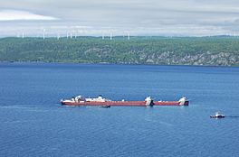
MV Roger Blough aground in Whitefish Bay with Prince Wind Farm in the background
|
|
| Location | Lake Superior, Michigan and Ontario |
| Coordinates | 46°42′8″N 84°47′20″W / 46.70222°N 84.78889°W |
| Type | Bay |
| Primary outflows | St. Marys River |
| Surface elevation | 604 feet (184 m) |
Whitefish Bay is a large bay on the eastern side of Lake Superior. It sits between Michigan in the United States and Ontario in Canada. This bay is a very important pathway for ships. They travel through it to reach the Soo Locks or to leave them.
Whitefish Bay: A Gateway to Lake Superior
Whitefish Bay is located between Whitefish Point in Michigan and Whiskey Point in Ontario. The Canadian side of the bay has a rugged, wild landscape called the Canadian Shield. The international border runs right through the middle of the bay.
Guiding Lights: Lighthouses of the Bay
Several lighthouses help guide ships safely through Whitefish Bay. The Whitefish Point Light marks the entrance to the bay. The Ile Parisienne Light is found in the middle of the bay. The Gros Cap Reefs Light is near the exit of the bay. It helps ships as they approach the Soo Locks at Sault Ste. Marie, Michigan.
The Whitefish Point Lighthouse is the oldest lighthouse still working on Lake Superior. Part of the lighthouse area is now home to the Great Lakes Shipwreck Museum. This museum displays items from shipwrecks. It also shares information about famous shipwrecks. One well-known wreck is the SS Edmund Fitzgerald from 1975. All 29 crew members were lost in that accident.
Shipwrecks and Underwater Treasures
After the Soo Locks opened in 1855, more ships started using Lake Superior. This made Whitefish Bay a place where many ships were wrecked. Bad weather often caused these accidents.
The Whitefish Point Underwater Preserve was created to protect these shipwrecks. This allows future generations of divers to explore them. Some of the known shipwrecks in the bay include the Comet, John B. Cowle, Drake, Samuel Mather, Miztec, Myron, Niagara, John M. Osborn, Sagamore, Superior City, and Vienna.
 | Leon Lynch |
 | Milton P. Webster |
 | Ferdinand Smith |


