Neebish Island facts for kids
|
Native name:
Aniibiish (Ojibwe)
|
|
|---|---|
| Geography | |
| Location | St. Marys River |
| Coordinates | 46°16′14.8″N 84°09′16.5″W / 46.270778°N 84.154583°W |
| Total islands | 2 |
| Major islands | Big Neebish, Little Neebish |
| Area | 21.5 sq mi (56 km2) |
| Highest elevation | 571 ft (174 m) |
| Administration | |
|
United States
|
|
| State | Michigan |
| County | Chippewa |
| Township | Soo |
| Demographics | |
| Population | 89 (2010) |
| Pop. density | 4.14 /sq mi (1.598 /km2) |
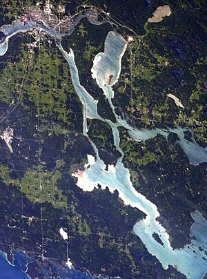
Neebish Island is a small island in the St. Marys River in Michigan, United States. This river connects two of the Great Lakes: Lake Superior and Lake Huron. The island is found at the eastern tip of Michigan's Upper Peninsula.
Neebish Island is west of the border between the U.S. and Canada. It is part of the important Great Lakes-St. Lawrence Seaway shipping route. Large ships going to Lake Superior pass on the island's east side. Ships heading down to Lake Huron use a deeper channel on the island's west side. About 90 people live on the island all year. Many visitors also come to Neebish Island for vacations, staying in cottages or camping.
Contents
Island History: How Neebish Got Its Name
When the first Europeans arrived in the early 1600s, Native American tribes lived around Neebish Island. These included the Ojibwe, Odawa, and Potawatomi peoples. They all spoke languages from the Algonquian family. Their ancestors had moved to the Great Lakes area around the year 1200.
Many people believe the island's name, Neebish, comes from the Ojibwe word aniibiish. This word means "leaf."
After the War of 1812 between the U.S. and Great Britain, both countries wanted to fix their border. They had argued about the border since the American Revolutionary War. So, they chose people to survey the land and decide where the border should be. This was based on the Treaty of Paris from 1783.
During this time, Neebish Island was called St. Tammany Island. A British official suggested this name to honor the U.S. But the new name did not last. In 1821, both countries agreed that the island would belong to the United States.
At first, the water channel between Neebish Island and the Michigan mainland was very shallow. Only small boats could use it. Because of this, the first settlements grew on the east side of the island. Many were on Little Neebish, a smaller island southeast of the main one.
In 1853, Major William Rains was one of the first European settlers on Little Neebish. He was British and had tried to start a settlement on St. Joseph Island in Canada. When that plan failed, Rains and his family moved to Little Neebish. For a while, Little Neebish was even called Rains Island after him.
A private saw mill operated on the island from 1877 to 1893. It was near the small creek between Big Neebish and Little Neebish. At its busiest, the mill employed 150 men.
Neebish Island had its own telephone service starting in 1924. It was called the Neebish Mutual Telephone Company. Islanders did not get electricity until the mid-1950s.
In 1933, a private company started a car ferry service. This ferry connected the Michigan mainland to the west side of the island. In 1980, the Eastern Upper Peninsula Transportation Authority took over this ferry service.
Building the West Neebish Channel
In 1855, the first ship canal and locks were finished at Sault Ste. Marie. These locks allowed much larger ships to travel on the St. Marys River. To help these big ships, the U.S. government dug and used dynamite to clear limestone. This work happened in the Munuscong Channel in 1856 and 1905.
At first, all ships going up or down the St. Marys River had to use the twisting Munuscong Channel. On September 5, 1899, a ship called the Douglass Houghton sank. It blocked the channel for several days. This event showed that another route was needed.
The "Houghton Blockade" proved that a second channel was important. With two channels, ships going upriver could use one, and ships going downriver could use the other. This would make shipping safer and faster.
So, in 1903, work began to make the channel between Neebish Island and the Michigan mainland wider and deeper. This new channel, called the West Neebish Channel, opened in 1908. It was for ships traveling downriver. This work also smoothed out the Neebish rapids that used to be on the west side of the island.
Island Geography: Where is Neebish Island?
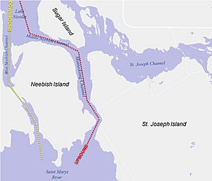
Neebish Island is about 21.5 square miles (55.7 square kilometers) in size. It is south of Sugar Island. To its east is St. Joseph Island in Canada. To its west and south is the eastern part of Michigan's Upper Peninsula.
The island has two main parts: "Big Neebish" and "Little Neebish." Little Neebish is southeast of the main island. A narrow, shallow creek separates them. Islanders sometimes call this creek 'the dark hole' or 'the black hole'.
About four square miles of the island are owned by the state. Most of Neebish Island is still undeveloped, meaning it does not have many buildings.
Island Government: Who Represents Neebish?
Neebish Island is the most southeastern part of Soo Township. This township is in Chippewa County, Michigan.
The people living on Neebish Island have representatives in the Michigan Legislature. They are also represented in the U.S. government. Their representative in the House of Representatives is from Michigan's 1st congressional district.
Transportation: Getting Around Neebish Island
Water Travel
You can only reach Neebish Island by water. A ferry carries both vehicles and people to the island. It connects Neebish Island with Bruce Township on the Michigan mainland. The ferry runs mostly during warmer months. In summer, it leaves every two hours. There are extra trips during busy morning and afternoon times. The ferry does not run from January 15 to April 1. In 2006, the ferry carried about 3,300 passengers and 2,175 vehicles each month.
The Eastern Upper Peninsula Transportation Authority owns and maintains the ferry. A private company operates it.
Neebish Island is a key spot for shipping on the Great Lakes-St. Lawrence Seaway. Ships going up the St. Marys River toward Lake Superior use the Munuscong Channel on the island's east side. Ships going downriver to Lake Huron use the deeper West Neebish Channel on the island's west side.
Roads on the Island
Brander Road runs north to south through the middle of Neebish Island. East 15 Mile Road crosses the island from east to west. This road is a separate part of the road with the same name in Bruce Township. The ferry docks on a road called East Neebish Ferry Road on both the mainland and the island.
Island Culture: Life on Neebish
In the past, Neebish Island had many one-room school houses. Most of these are no longer used today. A community center was built where one of the old school houses used to be. It is next to the fire station.
Many families have owned cottages on the island for generations. Neebish Island is a popular place for seasonal visitors to stay in cottages. The Neebish Island Resort offers cottage rentals and other services for tourists.
A small general store and resort, called the Little Neebish Resort, burned down in the 1990s. The Neebish Island Resort now has a general store that opens seasonally. Another general store used to be by the original ferry dock. It was owned by Charlotte Laitinen but closed in the early 2000s.
Neebish Island was the birthplace of Pat Norton (1931-2001). She was a local painter. Her artwork showed scenes from the St. Marys River, lake freighters, churches, and other island views. Pat grew up seeing many lake freighters because her father was a lighthouse keeper. She specialized in watercolor paintings.
Pine River Camp was a canoe camp on Neebish Island. It brought young people from all over the United States. The camp ran for almost 30 years, from the late 1960s until it closed in 1993. It had simple cabins. The dining hall was a pavilion with a dirt floor and log poles. Meals were cooked over a campfire nearby.
Neebish Island in Movies
Neebish Island was mentioned in the 2010 movie The Switch. In the film, the character Roland Nilson (played by Patrick Wilson) says his parents have a cabin on Neebish Island.
 | Mary Eliza Mahoney |
 | Susie King Taylor |
 | Ida Gray |
 | Eliza Ann Grier |


