
Hulbert Township, Michigan facts for kids
Quick facts for kids
Hulbert Township, Michigan
|
|
|---|---|

Hulbert Township Hall in Hulbert
|
|

Location within Chippewa County
|
|

Hulbert Township, Michigan
Location in Michigan

Hulbert Township, Michigan
Location in the United States
|
|
| Country | United States |
| State | Michigan |
| County | Chippewa |
| Established | 1888 |
| Area | |
| • Total | 71.82 sq mi (186.01 km2) |
| • Land | 70.85 sq mi (183.50 km2) |
| • Water | 0.97 sq mi (2.51 km2) |
| Elevation | 735 ft (224 m) |
| Population
(2020)
|
|
| • Total | 171 |
| • Density | 2.41/sq mi (0.93/km2) |
| Time zone | UTC-5 (Eastern (EST)) |
| • Summer (DST) | UTC-4 (EDT) |
| ZIP code(s) | |
| Area code(s) | 906 |
| FIPS code | 26-39860 |
| GNIS feature ID | 1626502 |
Hulbert Township is a small community in Chippewa County, Michigan, in the United States. It is a type of local government area called a civil township. In 2020, only 171 people lived here, making it the least populated place in Chippewa County.
Contents
Exploring Hulbert Township's Location
.jpg)
Hulbert Township is found in the western part of Chippewa County. This area is part of Michigan's Upper Peninsula. To its west, you'll find Luce County, and to the south is Mackinac County.
Getting Around Hulbert Township
A main road, M-28, goes through the township. This highway connects Hulbert Township to Sault Ste. Marie in the east and Newberry in the west. The small community of Hulbert itself is about 1.5 miles north of M-28. It's located along an old railway line.
Land and Water in Hulbert Township
The township covers a total area of about 71.8 square miles (186.0 square kilometers). Most of this area, about 70.8 square miles (183.5 square kilometers), is land. The rest, about 0.97 square miles (2.5 square kilometers), is water.
The biggest body of water here is Hulbert Lake. It's in the eastern part of the township, south of M-28. This lake also stretches into Chippewa Township. A large part of Hulbert Township is covered by the Lake Superior State Forest, which means lots of trees and nature!
Who Lives in Hulbert Township?
In 2000, there were 211 people living in Hulbert Township. These people lived in 89 different homes. Most of the people living here were White. A smaller number were Native American or from two or more different backgrounds.
Families and Households
Out of the 89 homes, about 19% had children under 18 living there. More than half of the homes (about 54%) were married couples living together. Some homes (about 11%) had a female head of the house without a husband. About one-third of all homes were made up of single people. Many older people, aged 65 or more, lived alone.
Age Groups in the Township
The people in Hulbert Township were of different ages:
- About 17% were under 18 years old.
- About 6% were between 18 and 24 years old.
- About 22% were between 25 and 44 years old.
- About 28% were between 45 and 64 years old.
- About 28% were 65 years old or older.
The average age of people in the township was 50 years.
Images for kids
-
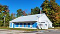
Hulbert Township Hall in Hulbert
-
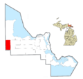
Location within Chippewa County
See also
 In Spanish: Municipio de Hulbert (Míchigan) para niños
