
Anticosti Island facts for kids

Salmon fisherman on Rivière à l'Huile
|
|

Anticosti Island
Location in Quebec
|
|
| Geography | |
| Location | Gulf of Saint Lawrence |
| Coordinates | 49°30′N 63°00′W / 49.500°N 63.000°W |
| Area | 7,923.16 km2 (3,059.15 sq mi) |
| Length | 222 km (137.9 mi) |
| Width | 56 km (34.8 mi) |
| Administration | |
| Province | Quebec |
| Region | Côte-Nord |
| County | Minganie |
| Largest Municipality | L'Île-d'Anticosti |
| Demographics | |
| Population | 240 |
Anticosti Island (French: Île d'Anticosti) is a large island in Quebec, Canada. It is located where the Saint Lawrence River meets the Gulf of Saint Lawrence. The island is part of the Minganie Regional County Municipality.
Anticosti Island is about 7,923 square kilometers (3,059 square miles) in size. This makes it the 90th largest island in the world. It is also the 20th largest island in Canada. The island is separated from the Quebec mainland by the Jacques Cartier Strait. To the south, the Honguedo Strait separates it from the Gaspé Peninsula.
Even though it is larger than Prince Edward Island, Anticosti Island has very few people living there. In 2011, only 240 people lived on the island. Most of them live in the village of Port-Menier. This village is on the western tip of the island. The entire island is one municipality called L'Île-d'Anticosti.
More than 400 ships have been wrecked near Anticosti Island. Because of this, it is sometimes called the "Cemetery of the Gulf."
Contents
Discover the Geography of Anticosti Island

Anticosti Island is part of the eastern Saint Lawrence lowlands. It is about 222 kilometers (138 miles) long. Its widest point is 56 kilometers (35 miles) across. The island's coastline is 520 kilometers (323 miles) long. It is rocky and can be dangerous for ships. There are not many safe places for boats to stop.
The biggest lake on the island is Lake Wickenden. This lake feeds the Jupiter River. Many rivers flow across Anticosti Island. They often run through deep canyons to the north and south shores.
The island has three main land areas. There are two low-lying areas, one in the east and one in the west. These areas are usually less than 150 meters (490 feet) high. A central highland forms a plateau that rises to over 300 meters (980 feet). The rocks on the island show a long history of Earth's past. They are from the Ordovician and Silurian periods. These are very old time periods in Earth's history.
Major Rivers of Anticosti Island
Here are some of the main rivers on Anticosti Island:
South shore rivers (from west to east):
- Plantain River
- Gamache River (Anticosti Island)
- Jupiter River
- Chicotte River
- Pavillon River
- Chaloupe River (Anticosti Island)
- Bell River (Anticosti Island)
North shore rivers (from west to east):
- Huile River
- Vauréal River
- Natiscotec River
- Rivière aux Saumons (Anticosti Island)
- Prinsta River
Anticosti Island's Climate
Anticosti Island has a cool, wet climate. It is called a sub-boreal climate. The nearby Gulf of Saint Lawrence makes the temperatures less extreme. The average temperature for the whole year is about 1.9°C (35.4°F).
July is the warmest month, with an average of 14.79°C (58.6°F). February is the coldest, averaging -11.2°C (11.8°F). The island gets a lot of snow. More than 300 centimeters (118 inches) of snow can fall in the western and central parts.
| Climate data for Port Menier (1951–1980) | |||||||||||||
|---|---|---|---|---|---|---|---|---|---|---|---|---|---|
| Month | Jan | Feb | Mar | Apr | May | Jun | Jul | Aug | Sep | Oct | Nov | Dec | Year |
| Record high °C (°F) | 7.2 (45.0) |
8.3 (46.9) |
10.0 (50.0) |
18.3 (64.9) |
24.4 (75.9) |
31.1 (88.0) |
27.8 (82.0) |
28.9 (84.0) |
25.6 (78.1) |
20.6 (69.1) |
13.9 (57.0) |
11.1 (52.0) |
31.1 (88.0) |
| Mean daily maximum °C (°F) | −6.2 (20.8) |
−5.7 (21.7) |
−1.8 (28.8) |
3.5 (38.3) |
9.3 (48.7) |
15.8 (60.4) |
19.0 (66.2) |
18.0 (64.4) |
13.6 (56.5) |
8.1 (46.6) |
2.7 (36.9) |
−3.5 (25.7) |
6.1 (43.0) |
| Daily mean °C (°F) | −10.5 (13.1) |
−10.9 (12.4) |
−5.9 (21.4) |
−0.5 (31.1) |
5.5 (41.9) |
11.2 (52.2) |
15.3 (59.5) |
13.9 (57.0) |
9.8 (49.6) |
4.4 (39.9) |
−0.7 (30.7) |
−7.3 (18.9) |
2.0 (35.6) |
| Mean daily minimum °C (°F) | −15 (5) |
−16.1 (3.0) |
−10.7 (12.7) |
−4.4 (24.1) |
1.4 (34.5) |
6.6 (43.9) |
11.5 (52.7) |
9.7 (49.5) |
5.8 (42.4) |
0.6 (33.1) |
−4.0 (24.8) |
−10.9 (12.4) |
−2.1 (28.2) |
| Record low °C (°F) | −36.7 (−34.1) |
−37.8 (−36.0) |
−38.3 (−36.9) |
−21.7 (−7.1) |
−12.2 (10.0) |
−5.0 (23.0) |
0.6 (33.1) |
0.6 (33.1) |
−6.7 (19.9) |
−11.1 (12.0) |
−21.1 (−6.0) |
−31.7 (−25.1) |
−38.3 (−36.9) |
| Average precipitation mm (inches) | 79.5 (3.13) |
65.6 (2.58) |
53.6 (2.11) |
54.3 (2.14) |
75.1 (2.96) |
79.6 (3.13) |
85.0 (3.35) |
80.8 (3.18) |
86.8 (3.42) |
92.5 (3.64) |
81.0 (3.19) |
74.1 (2.92) |
907.9 (35.74) |
| Average rainfall mm (inches) | 11.7 (0.46) |
7.5 (0.30) |
6.4 (0.25) |
26.1 (1.03) |
69.9 (2.75) |
79.6 (3.13) |
85.0 (3.35) |
80.8 (3.18) |
86.8 (3.42) |
85.6 (3.37) |
55.5 (2.19) |
15.1 (0.59) |
610.0 (24.02) |
| Average snowfall cm (inches) | 78.4 (30.9) |
62.1 (24.4) |
51.9 (20.4) |
28.8 (11.3) |
5.2 (2.0) |
0.0 (0.0) |
0.0 (0.0) |
0.0 (0.0) |
0.0 (0.0) |
6.0 (2.4) |
30.5 (12.0) |
64.9 (25.6) |
327.8 (129.1) |
| Average precipitation days (≥ 0.2 mm) | 16 | 12 | 10 | 11 | 11 | 10 | 12 | 11 | 10 | 12 | 12 | 14 | 141 |
| Average rainy days (≥ 0.2 mm) | 3 | 1 | 2 | 6 | 10 | 10 | 12 | 11 | 10 | 12 | 7 | 2 | 86 |
| Average snowy days (≥ 0.2 cm) | 14 | 10 | 9 | 5 | 1 | 0 | 0 | 0 | 0 | 1 | 6 | 13 | 59 |
| Mean monthly sunshine hours | 77.6 | 121.0 | 137.0 | 163.8 | 243.2 | 243.8 | 243.8 | 253.2 | 172.4 | 127.4 | 95.5 | 62.8 | 1,941.5 |
| Source: Environment Canada | |||||||||||||
History of Anticosti Island
For thousands of years, Indigenous peoples used Anticosti Island for hunting. The Innu people called it Notiskuan, meaning "where bears are hunted." The Mi'kmaq people called it Natigôsteg, which means "forward land."
Early European Exploration and Settlement
The French explorer Jacques Cartier sailed past the island in 1534. He named it Isle de l'Assomption. This was because he arrived on the Day of the Assumption of Mary. This name was not used anymore by 1656. Later, the island was called Naticousti or Antiscoti. France officially took control of the island.
The first European settlers came in 1680. King Louis XIV gave the island to Louis Jolliet. Jolliet was an explorer who had explored the Mississippi River and Hudson Bay. He built a fort on Anticosti and settled there with his family. In 1690, some Massachusetts troops captured his fort.
After Jolliet died in 1700, his sons owned the island. The Jolliet family kept it until 1763. Then, the island became part of British North America after the Seven Years' War. Over the years, the island changed hands many times. Owners mostly used it for cutting timber. No big developments happened.
Later Ownership and Development
In 1874, the Anticosti Island Company bought the island. They started villages at English Bay and Fox Bay. Most people living there were lighthouse keepers. Because of many shipwrecks, supplies were kept around the island for sailors. In 1882, a church parish was founded. In 1884, the Stockwell brothers owned the island. They tried to start a forestry company but it failed. By the 1890s, the island's wildlife was almost gone from too much hunting.

In 1895, a French chocolate maker named Henri Menier bought Anticosti for $125,000. He named the Vauréal Falls after his hometown in France. He built the village of Port-Menier. He also built a factory for packing fish and lobsters. Menier tried to use the island's wood, peat, and minerals. Many of the original houses he built are still there today.
Menier also turned the island into a private hunting area. He brought in animals that were not native to the island. This included 220 white-tailed deer. The deer population grew a lot, and now there are over 160,000 deer. The island's moose population is about 1,000. It is thought that black bears used to live on the island. They might have disappeared because the deer ate all the berry bushes.
Henri Menier died in 1913. His brother Gaston became the owner. He later sold the island in 1926 for $6,000,000 to the Wayagamack Pulp and Paper Company. For the next 50 years, logging companies used the island. They did not protect the environment or historical sites. The villages at English Bay and Fox Bay were left empty.
During the Great Depression, the paper market crashed. Consolidated Paper Corporation Limited took over the island in 1931. They tried to sell it. In 1937, a group of Dutch and German business people wanted to buy it. They planned to build a paper mill. A team of German surveyors visited the island. A newspaper story claimed they were Adolf Hitler's agents. People were suspicious, but an investigation found no evidence of this. The sale did not happen.
In 1974, the government of Quebec bought the island for $23,780,000. It was put under the care of the Ministry of Recreation, Hunting and Fishing. In 1983, a local government structure was started. Today, about 60% of the island is managed by Sépaq. Since 2001, 572 square kilometers (221 square miles) have been made into a national conservation park. The island has 24 rivers with salmon and trout. It is now a popular place for fishing and hunting. People also visit for paleontology, bird watching, and hiking.
Getting to Anticosti Island
You can get to Anticosti Island by boat or plane. The company Relais Nordik offers boat service to Port-Menier. Boats arrive twice a week from April to mid-January.
The Port-Menier Airport has regular flights. Air Liaison flies to Sept-Îles and Havre-St-Pierre. There are two other small airports on the eastern side of the island. These are Rivière-aux-Saumons and Rivière Bell. They are used by companies that offer private flights for tourists.
The Henri-Menier Road is the main road on the island. It is unpaved and goes from Port-Menier to the eastern tip. Many smaller roads branch off it. These roads lead to tourist spots and logging areas. You can rent a car in Port-Menier.
Plants of Anticosti Island

The forests on Anticosti Island are typical boreal forests. Common trees include white spruce, balsam fir, and black spruce. There are also some American white birch and trembling aspen trees.
Balsam fir trees are slowly being replaced by white spruce. This is because deer eat the young fir trees. Also, insects like the hemlock looper and spruce budworm cause damage. About a quarter of the island is covered by peat lands.
Anticosti Island is special because of the rare lady's slipper orchid. This orchid is becoming less common in other parts of eastern North America. But it grows very well on Anticosti, making the island a safe place for this plant.
Animals of Anticosti Island
The animals on Anticosti Island are typical for an isolated island. Of the 24 types of mammals, 14 are marine mammals. These include grey seals and harbour seals. Large whales also swim in the cold waters nearby.
Originally, there were probably only seven types of land mammals. These were the red fox, river otter, deer mouse, American marten, black bear, and two types of bats. The marten and bear have now disappeared. Black foxes have been seen on the island.
Since 1896, many new animal species have been brought to Anticosti Island. This was done to make it a good place for hunting. In total, 16 new species were introduced. Six of them did not survive, like bison and caribou. But ten species have done well. These include six land mammals like white-tailed deer, moose, beaver, snowshoe hare, and muskrat. Two types of frogs and two types of non-migratory birds (like ruffed grouse) also did well.
The white-tailed deer have been especially successful. About 200 deer were brought to the island in 1896 and 1897. Today, there are an estimated 160,000 deer. This means there are about 20 deer per square kilometer. There are no natural predators for the deer. This high number of deer has greatly changed the island's ecosystem. Balsam fir trees used to cover about 40% of the island. But the deer eat the young fir trees, so white spruce trees are replacing them.
Brook trout, Atlantic salmon, and American eel live in the rivers and along the shores.
About 221 types of birds have been seen on Anticosti Island. Nearly 60% of Quebec's known bald eagle nesting sites are on the island.
Tourism and Outdoor Fun
Anticosti Island is known for its wild nature and many animals. It is a great place for hunting, fishing, and other outdoor activities. About 3,000 to 4,000 hunters visit each year.
Most of Anticosti Island (4,213 square kilometers or 1,627 square miles) is managed by Sépaq Anticosti. This is a part of Quebec's parks and wildlife agency. They encourage tourism, especially hunting and fishing trips. Another 572 square kilometers (221 square miles) are protected as the Anticosti National Park (Parc national d'Anticosti). In this park, you can also enjoy hiking, horseback riding, nature watching, and sea kayaking.
There are also five private companies that offer hunting and fishing trips. They have special rights to 7,263 square kilometers (2,804 square miles) of the island.
Energy Resources: Utica Shale
The Utica Shale is a layer of rock found under Anticosti Island. It is from the Ordovician period, a very old time in Earth's history. This rock layer might contain a lot of shale gas. This gas is a type of natural gas found in shale rock.
In 2011, a group called "Non au Pétrole et au Gaz au Québec" (No to Oil and Gas in Quebec) protested against hydraulic fracturing (fracking) in Quebec. Fracking is a method used to get gas from shale. They collected 128,000 signatures on a petition. In June 2011, a Quebec company called Pétrolia said they found about 30 billion barrels of oil on Anticosti Island. This was the first time such large amounts were found in Quebec.
In February 2014, the Premier of Quebec, Pauline Marois, announced that the government would help pay for two projects to explore for shale gas. The province promised $115 million. In return, they would get rights to 50% of the licenses and 60% of any profits. This was a big deal for oil and gas in Quebec. However, a new government came into power in April 2014, and they might change this decision.
In 2013, the citizen group "Non au Pétrole et au Gaz au Québec" started another petition. They wanted to stop fracking and oil and gas exploration on Anticosti Island. They asked for a pause and an environmental review. A geological engineer explained that at least 12,000 wells would be needed. He said this would cost Quebec a lot of money. When the government announced the $115 million investment, the petition grew to 36,000 signatures. The government has not yet started a specific environmental review for Anticosti.
Images for kids
-
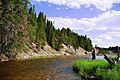
Salmon fisherman on Rivière à l'Huile
-
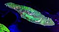
Satellite image of Anticosti Island
-
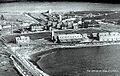
Port-Menier, Anticosti Island, in 1922
-
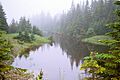
Boreal forest on Anticosti Island
See also
 In Spanish: Isla de Anticosti para niños
