
Zakarpattia Oblast facts for kids


Zakarpattia Oblast is a special region, or province, located in western Ukraine. Its main city and administrative center is Uzhhorod. Other important cities in the region include Mukachevo, Khust, Berehove, and Chop, which is a key place for train travel.
Zakarpattia Oblast was officially created on January 22, 1946. This happened after the lands known as Subcarpathian Rus became part of the Ukrainian Soviet Socialist Republic. In 1991, during a vote for Ukraine's independence, people in Zakarpattia Oblast also voted on whether their region should have more self-rule. Many people wanted this, but it was not granted.
This region is nestled in the beautiful Carpathian Mountains in western Ukraine. It's the only part of Ukraine that shares borders with four different countries: Poland, Slovakia, Hungary, and Romania. The Carpathian Mountains are very important for the region's economy, making it a popular spot for tourists. Many people visit for its ski resorts and relaxing spa towns.
Zakarpattia Oblast is the 23rd largest region in Ukraine by area and the 17th largest by population. In 2001, about 1.25 million people lived here. While most people are Ukrainian, there are also many other groups. These include Hungarians, Romanians, and Rusyns. In some cities, these groups make up a large part of the population, or even the majority, like in Berehove.
Contents
Geography of Zakarpattia Oblast
Zakarpattia Oblast covers an area of 12,800 square kilometers (about 4,942 square miles). It is located in the Carpathian Mountains in western Ukraine. This region is unique because it borders four different countries: Poland, Slovakia, Hungary, and Romania.
To the west, it borders parts of Slovakia and Hungary. To the south, it borders parts of Romania. To the east and northeast, it borders the Ivano-Frankivsk Oblast in Ukraine. To the north, it borders the Lviv Oblast in Ukraine and a part of Poland.
Most of Zakarpattia Oblast is covered by mountains and small hills. These are filled with forests that have both deciduous (trees that lose their leaves) and coniferous (evergreen) trees. There are also high alpine meadows. About 80% of the region is mountainous, with ranges stretching from the northeast to the southeast. Some of the ancient beech forests here are so special that they were named a UNESCO World Heritage Site in 2007.
The biggest rivers flowing through the region are the Tysa, Borzhava, and Tereblia. The weather here is moderate, meaning it's not too extreme. It gets about 700-1000 millimetres (27-39 inches) of rain each year. In summer, the average temperature is around 21°C (70°F), and in winter, it's about -4°C (25°F).
The highest point in the region is Hoverla mountain, which is 2,061 meters (6,762 feet) tall. It's part of the Chornohora mountain range. The lowest point is 101 meters (331 feet) above sea level, found in the village of Ruski Heyevtsi.
Several historical and cultural places in Zakarpattia Oblast were nominated for the "Seven Wonders of Ukraine" competition in 2007. These included Palanok Castle, the Museum upon the Chorna River, Mykhailiv Orthodox Church, and Nevytsky Castle.
History of Zakarpattia Oblast
For a long time, Zakarpattia was part of the Kingdom of Hungary, and later Austria-Hungary. After World War I ended, Austria-Hungary broke apart. This region was briefly part of a short-lived country called the West Ukrainian National Republic in 1918. Then, Romania took control of it for a short time. In the summer of 1919, Hungary took it back.


Finally, Zakarpattia joined the newly formed country of Czechoslovakia. It was known as Subcarpathian Rus and was one of the four main regions of Czechoslovakia.
During World War II, when Germany occupied Czechoslovakia, the southern part of Zakarpattia was given to Hungary in 1938. The rest of the region became an independent area within Czechoslovakia. On March 15, 1939, after Germany occupied other parts of Czechoslovakia, Ruthenia (another name for the region) declared its own independence as the Republic of Carpatho-Ukraine. However, Hungary immediately occupied and then took over this new country.
In 1944, during the German occupation of Hungary, most of the Jewish people in the region were sent away. Very few survived the Holocaust. When the Soviet Army arrived in 1944, they did not allow Czechoslovak officials to take control again. In June 1945, the president of Czechoslovakia officially signed a treaty giving the area to the Soviet Union. It then became part of the Ukrainian Soviet Socialist Republic. After the Soviet Union broke up, it became part of independent Ukraine and was named Zakarpattia Oblast.
An interesting fact about this region is that its first governor was an American citizen named Gregory Zatkovich. He had moved from the region to the U.S. earlier and represented the Rusyn community there. He was appointed governor in 1920 by Czechoslovakia's first president, Tomáš Garrigue Masaryk. He served for about a year before resigning because he disagreed about how much self-rule the region should have.
After the Soviet Union fell in 1991, Ukraine held a vote for independence. People in Zakarpattia were also asked if they wanted more self-rule for their region. About 78% of the people voted for it, but it was not granted. There were also ideas about rejoining Czechoslovakia. However, after Czechoslovakia split into the Czech Republic and Slovakia in 1993, these ideas were no longer possible.
How Zakarpattia Oblast is Governed
The local government of Zakarpattia Oblast is managed by the Zakarpattia Oblast Council, also called the rada. The person in charge of the Council is called the Chairman.
The oblast's governor is chosen by the President of Ukraine.
Parts of Zakarpattia Oblast

Zakarpattia Oblast is divided into 13 smaller areas called raions (districts). There are also 5 cities that are directly managed by the oblast government. These cities are Berehove, Chop, Khust, Mukachevo, and the main city, Uzhhorod. In total, the region has 11 cities, 19 towns, and more than 579 villages.
The region can also be thought of as four historical areas: Ung, Bereg, Ugocsa, and Northern Maramuresh.
Here's a quick look at the types of places in Zakarpattia Oblast:
- The main city is Uzhhorod.
- There are 13 raions (districts).
- There are 579 villages.
- There are 30 cities and towns in total.
Raions (Districts)
Here are the 13 districts in the oblast:
- Berehivskyi Raion
- Irshavskyi Raion
- Khustskyi Raion
- Mizhhirskyi Raion
- Mukachivskyi Raion
- Perechynskyi Raion
- Rakhivskyi Raion
- Svaliavskyi Raion
- Tiachivskyi Raion
- Uzhhorodskyi Raion
- Velykobereznianskyi Raion
- Volovetskyi Raion
- Vynohradivskyi Raion
Cities and Towns
These are some of the largest cities and towns in the region (with their populations in 2007):
- Uzhhorod (118,231 people)
- Mukachevo (81,344 people)
- Khust (27,506 people)
- Berehove (25,288 people)
- Vynohradiv (24,366 people)
- Svaliava (16,217 people)
- Rakhiv (14,416 people)
- Tiachiv (9,256 people)
- Mizhhiria (9,133 people)
- Irshava (9,000 people)
- Velykyy Bychkiv (8,920 people)
- Solotvyno (8,774 people)
- Dubove (8,745 people)
- Velyki Luchky (8,540 people)
- Chop (8,436 people)
- Ilnytsia (8,420 people)
- Bushtyno (8,091 people)
People of Zakarpattia Oblast
According to a census in 2001, about 1,254,614 people lived in Zakarpattia Oblast. Today, the population is estimated to be around 1.2 million.
Most people in Zakarpattia are Ukrainians, making up about 80.5% of the population. However, many other ethnic groups also live here. The largest of these are Hungarians (12.1%), Romanians (2.6%), Russians (2.5%), Roma (1.1%), Slovaks (0.5%), and Germans (0.3%). About 10,100 people also identify themselves as Rusyns.
The languages and cultures of these groups are respected. For example, there are schools and clubs that use their languages. Most people (81.0%) speak Ukrainian as their first language. Others speak Hungarian (12.7%), Russian (2.9%), Romanian (2.6%), and Rusyn (0.5%). In some villages, children can even learn Hungarian in school.
Zakarpattia is home to about 14,000 Roma people, also known as Gypsies. This is the largest Roma population in Ukraine. The first Hungarian College in Ukraine, called the II. Rákoczi Ferenc College, is located in Berehove.
Economy of Zakarpattia Oblast
.jpg)
The economy of Zakarpattia Oblast mainly relies on trade across its borders, making wine, and forestry (working with wood from forests). The region also has a special economic zone, which helps businesses.
The main industry here is woodworking. Other important industries include food production, light industry (making things like clothes or small electronics), and mechanical engineering. Food products make up about 45% of the goods produced for local use. There are 319 large industrial companies and 733 smaller ones.
Farmers in the region mostly grow cereals (like wheat), potatoes, and other vegetables. In 1999, they produced a lot of grain, sunflower seeds, and potatoes. The region also produced a good amount of meat, milk, and eggs. In 1999, there were 1,400 registered farms in the region.
Images for kids
-
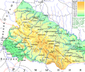
Ukrainian Carpathians, dividing Zakarpattia (on the south-western side) from Prykarpattia (on the north-eastern side)
-
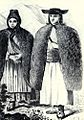
Carpathian highlanders
-
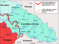
Map of Carpatho-Ukraine, an entity that lasted only one day (March 15, 1939)
-
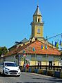
Berehove
-
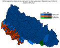
Languages of Zakarpattia Oblast in 2001.
-
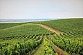
Vineyards near Muzhiyevo Village. Four major Ukrainian wineries are located in Zakarpattia oblast
-
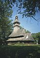
Church in Kolodne.
-
Morning in the Carpathian Biosphere Reserve
-

Svydovets (Drahobrat) Waterfall
-
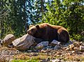
A bear in Synevyr National Nature Park
-

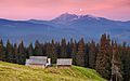
Landscape in Khust Raion


See also
 In Spanish: Óblast de Transcarpacia para niños
