Packwood, Washington facts for kids
Quick facts for kids
Packwood, Washington
|
|
|---|---|

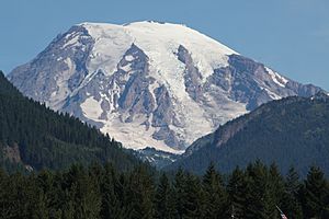
From Packwood, Mount Rainier and Butter Creek Canyon dominate the view to the north.
|
|

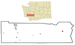
Location of Packwood in Lewis County, WA
|
|
| Country | United States |
| State | Washington |
| County | Lewis |
| Area | |
| • Total | 1.00 sq mi (2.58 km2) |
| • Land | 1.00 sq mi (2.58 km2) |
| • Water | 0 sq mi (0.0 km2) |
| Elevation | 1,053 ft (321 m) |
| Population
(2020)
|
|
| • Total | 319 |
| • Density | 343/sq mi (132.4/km2) |
| Time zone | UTC−8 (PST) |
| • Summer (DST) | UTC−7 (PDT) |
| ZIP code |
98361
|
| Area code(s) | 360 |
| GNIS feature ID | 1524132 |
| FIPS code | 53-52600 |
Packwood is a small community in eastern Lewis County, Washington, in the United States. It's known as an "unincorporated community" and a "census-designated place" (CDP). This means it's not an official city, but the government still counts its population. In 2020, about 319 people lived in the CDP. The larger Packwood area, including nearby neighborhoods, had a total population of 1,073 people.
Contents
The Name of Packwood
Packwood was first called Sulphur Springs. Later, its name changed to Lewis, honoring Meriwether Lewis from the famous Lewis and Clark Expedition. However, the United States Postal Service often confused it with Fort Lewis. So, the town was finally renamed Packwood. This new name honored William Packwood, an early explorer.
A Look Back: Packwood's History
Early Explorers and the Packwood Saddle
The town of Packwood, a mountain pass, and a lake are all named after William Packwood. He was a pioneer from Virginia who explored Oregon and Washington. William Packwood and James Longmire were given an important job. The Washington Territorial Legislature asked them to find a low path over the Cascade Range. This was needed because several travelers had died trying to cross the mountains. They successfully charted a path, called the Packwood Saddle. Even today, no road or trail uses this pass to cross the Cascades. Packwood is also home to the old Packwood Ranger Station.
Dealing with Floods
Packwood has faced serious floods over the years. In December 1977, heavy rain and melting snow caused a big flood. Eight homes were washed away, and many people had to leave. Several bridges were closed, cutting off Packwood from other areas. The Johnson Creek Bridge, a main road, even collapsed.
Another major flood happened in November 2006. Hundreds of people had to evacuate when a dike broke. Homes were swept away by the Cowlitz River, which rose very high. The powerful flood even changed the path of the river.
Packwood's Location and Surroundings
Packwood is located where US Highway 12 meets Gifford Pinchot National Forest Road 52. It sits between Mount Rainier National Park to the north and Mt. St. Helens National Volcanic Monument to the south.
The area is surrounded by beautiful wilderness. To the north, southeast, and northeast are the Tatoosh, Goat Rocks, and William O. Douglas Wilderness areas. The Gifford Pinchot National Forest acts as a natural buffer all around. Packwood is in the upper Cowlitz River valley. The White Pass Ski Area and the top of the Cascade Range mark the eastern edge of the Packwood area.
The U.S. Census Bureau says the Packwood CDP covers about 2.6 square kilometers (about 1 square mile) of land. The larger Packwood area includes several small communities. These include Goat Rocks, High Valley Park, and Timberline Village. This wider area has 1,073 full-time residents.
Packwood's Climate
Packwood has a climate called a "warm-summer Mediterranean climate." This means it has warm, dry summers and mild, wet winters.
| Climate data for Packwood | |||||||||||||
|---|---|---|---|---|---|---|---|---|---|---|---|---|---|
| Month | Jan | Feb | Mar | Apr | May | Jun | Jul | Aug | Sep | Oct | Nov | Dec | Year |
| Record high °F (°C) | 67 (19) |
77 (25) |
85 (29) |
90 (32) |
102 (39) |
104 (40) |
108 (42) |
105 (41) |
105 (41) |
97 (36) |
75 (24) |
63 (17) |
108 (42) |
| Mean daily maximum °F (°C) | 42.9 (6.1) |
48.1 (8.9) |
52.6 (11.4) |
59 (15) |
66.3 (19.1) |
71.6 (22.0) |
79 (26) |
79.1 (26.2) |
73.9 (23.3) |
61.9 (16.6) |
48.4 (9.1) |
42.3 (5.7) |
60.4 (15.8) |
| Mean daily minimum °F (°C) | 29.3 (−1.5) |
30.5 (−0.8) |
32.8 (0.4) |
36.5 (2.5) |
41.8 (5.4) |
47.4 (8.6) |
51 (11) |
50.7 (10.4) |
44.7 (7.1) |
38.5 (3.6) |
33.3 (0.7) |
29.8 (−1.2) |
38.9 (3.8) |
| Record low °F (°C) | −9 (−23) |
−2 (−19) |
2 (−17) |
20 (−7) |
20 (−7) |
27 (−3) |
28 (−2) |
29 (−2) |
23 (−5) |
17 (−8) |
−3 (−19) |
−8 (−22) |
−9 (−23) |
| Average precipitation inches (mm) | 9.01 (229) |
6 (150) |
5.31 (135) |
3.39 (86) |
2.54 (65) |
2.08 (53) |
0.72 (18) |
1.06 (27) |
2.24 (57) |
4.88 (124) |
8.87 (225) |
9.05 (230) |
55.14 (1,401) |
| Average snowfall inches (cm) | 11.8 (30) |
4.7 (12) |
2.8 (7.1) |
0.3 (0.76) |
0 (0) |
0 (0) |
0 (0) |
0 (0) |
0 (0) |
0 (0) |
1.9 (4.8) |
6.4 (16) |
27.9 (71) |
| Average precipitation days (≥ 0.01 inch) | 17 | 14 | 16 | 14 | 12 | 10 | 4 | 5 | 8 | 13 | 17 | 17 | 147 |
Arts and Culture in Packwood
Historic Buildings and Sites
Packwood is home to the La Wis Wis Guard Station No. 1165. This old cabin was built by the Civilian Conservation Corps. It is now listed on the National Register of Historic Places. This means it's an important historical site.
Parks and Outdoor Fun
Packwood offers several places for outdoor activities.
- Skate Creek Park Natural Area: This large area is owned by Washington State Parks. It covers about 180 acres. It's a great place to enjoy nature.
- Cowlitz River Public Access Park: Opened in 2022, this park lets people get close to the Cowlitz River. It has a nature trail for walking.
- Packwood Ballpark: This park has a baseball field and open spaces. It's a good spot for sports and other community events.
Packwood's Economy
Historically, Packwood's economy relied on the forest products industry. This means jobs related to logging and timber. Government jobs, like those with the National Forest and Park Services, also helped. Seasonal tourism has always been important too.
In 1998, the Packwood Lumber Mill closed, causing 220 people to lose their jobs. This was due to problems in the lumber industry. The Packwood Ranger Station also closed in 2003. This happened because of budget cuts in the US Forest Service. By 2010, many homes in Packwood became second homes or vacation rentals.
Packwood is now a popular vacation spot. The White Pass Ski Area brings visitors in winter. Mount Rainier National Park and Gifford Pinchot National Forest attract people in summer. Packwood also hosts the Packwood Flea Market. This is one of the largest flea markets in the western United States. It happens every Memorial Day and Labor Day weekend. Local groups are working to make Packwood even better for tourists. This includes improving places for visitors to stay and enjoy.
Education in Packwood
The first school in Packwood was built in 1915. At that time, the community was still called Lewis. The first class had 11 students. A new brick schoolhouse was built in 1938. In 1953, the Packwood boys' basketball team won the state championship!
Packwood is part of the White Pass School District. This district covers Packwood and nearby towns like Randle and Glenoma. In 2004, the number of school-age children in Packwood dropped. The local elementary school (for grades K-6) had to close. However, in 2007, the building became the White Pass Country Historical Museum. It now houses a local museum and hosts community events.
Getting Around Packwood
Packwood is easy to reach by car year-round using US 12. You can also use SR 123 and forest service roads during certain seasons. The Packwood Airport is a small airport for private planes.
The community is also part of a project to install EV charging stations. This project is along the White Pass Scenic Byway. It will help people with electric cars travel through the area.
See also
 In Spanish: Packwood (Washington) para niños
 | May Edward Chinn |
 | Rebecca Cole |
 | Alexa Canady |
 | Dorothy Lavinia Brown |

