West Side Highway, Washington facts for kids
Quick facts for kids
West Side Highway, Washington
|
|
|---|---|

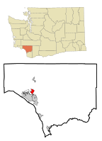
Location of West Side Highway CDP, Washington
|
|
| Country | United States |
| State | Washington |
| County | Cowlitz |
| Area | |
| • Total | 2.7 sq mi (6.9 km2) |
| • Land | 2.5 sq mi (6.5 km2) |
| • Water | 0.2 sq mi (0.4 km2) |
| Population
(2010)
|
|
| • Total | 5,517 |
| • Density | 2,206.8/sq mi (848.8/km2) |
| Time zone | UTC-8 (Pacific (PST)) |
| • Summer (DST) | UTC-7 (PDT) |
| FIPS code | 53-77745 |
West Side Highway was a special area in Cowlitz County, Washington. It was called a "census-designated place" (CDP). This means it was a community that the government counted for population, but it wasn't an official city or town.
The area got its name from a state road, SR 411, which runs through it. This highway goes north and south between the towns of Longview and Castle Rock.
In 2010, about 5,517 people lived in the West Side Highway area. Later, before the 2020 census, this CDP was divided into two new areas: Beacon Hill and Lexington.
Contents
Where Was West Side Highway Located?
The West Side Highway area was located in the state of Washington. Its exact spot was at coordinates 46.185921 degrees North and 122.915505 degrees West.
The United States Census Bureau reported that the entire area covered about 2.7 square miles (6.9 square kilometers). Most of this was land, about 2.5 square miles (6.5 square kilometers). A smaller part, about 0.2 square miles (0.4 square kilometers), was water.
Who Lived There?
In the year 2000, there were 4,565 people living in the West Side Highway area. These people lived in 1,635 homes, and 1,291 of these homes were families.
Most of the people living there were White (94.22%). There were also smaller groups of Native American (1.23%) and Asian (1.12%) people. About 1.99% of the population was Hispanic or Latino.
Families and Households
Many homes (38.7%) had children under 18 living there. About 65.4% of the homes were married couples living together. Some homes (8.8%) had a female head of the house with no husband present.
The average home had about 2.74 people. For families, the average size was about 3.04 people.
Age and Income
The people in West Side Highway were of different ages. About 28.6% were under 18 years old. About 14.3% were 65 years old or older. The average age of people in the area was 35 years.
In 2000, the average income for a household in West Side Highway was $46,604 per year. For families, the average income was $55,598 per year.
About 12.2% of all the people in West Side Highway lived below the poverty line. This included 15.1% of those under 18 and 11.5% of those 65 or older.
See also
 In Spanish: West Side Highway (Washington) para niños
 | Chris Smalls |
 | Fred Hampton |
 | Ralph Abernathy |

