
Spirit Lake (Washington) facts for kids
Quick facts for kids Spirit Lake |
|
|---|---|

Aerial view of the lake in 2005
|
|

Spirit Lake
Location in Washington (state)

Spirit Lake
Location in the United States
|
|
| Location | Mount St. Helens National Volcanic Monument, Skamania County, Washington, U.S. |
| Coordinates | 46°16′23″N 122°08′06″W / 46.27306°N 122.13500°W |
| Primary inflows | Precipitation, streams |
| Primary outflows | Drainage tunnel to South Coldwater Creek |
| Basin countries | United States |
| Surface elevation | 3,406 feet (1,038 m) (3,198 ft (975 m) before May 18, 1980) |
Spirit Lake is a beautiful lake located in Skamania County, Washington, in the United States. You can find it just north of the famous Mount St. Helens volcano. For many years, Spirit Lake was a very popular spot for tourists and campers.
Before the big volcano eruption in 1980, there were several camps right on the lake's shore. These included camps for Boy Scouts and Girl Scouts, plus two YMCA camps. There were also lodges like Spirit Lake Lodge where visitors could stay. One of these lodges was owned by Harry R. Truman, a well-known person who lived near the volcano.
Contents
How Spirit Lake Looked Before 1980
Before the 1980 eruption, Spirit Lake had two main sections. These sections filled what used to be river valleys. About 4,000 years ago, these valleys were blocked by natural mudflows and volcanic ash from Mount St. Helens. This created the lake we know as Spirit Lake.
The longest part of Spirit Lake was about 2.1 miles (3.4 km) long. Water flowed out of the lake into the North Fork Toutle River through a natural channel. The lake's water level stayed pretty steady, at an elevation of about 3,198 ft (970 m).
The Climate Around the Lake
The area around Spirit Lake used to have a very special type of climate. It was either a "dry-summer subarctic climate" or a "cold-summer Mediterranean climate." These types of climates are quite rare and are only found in a few small places around the world. We don't have recent weather information to know if the climate is still the same today.
The Mount St. Helens Eruption of 1980
When Mount St. Helens erupted on May 18, 1980, Spirit Lake was directly in the path of the volcano's powerful side blast. The blast and a huge landslide of debris pushed most of the lake's water out of its bed. This created a massive wave of water that went as high as 850 ft (260 m) up the mountain slopes!
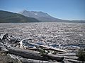
The landslide dumped a huge amount of material into Spirit Lake. This included about 430,000,000 cubic metres (350,000 acre⋅ft) of burnt trees, plants, volcanic ash, and other volcanic rocks. All this new material actually made the lake smaller by about 56,000,000 cubic metres (45,000 acre⋅ft).
The eruption also blocked the lake's natural outlet to the North Fork Toutle River. This caused the lake's surface to rise by about 197 ft (60 m) to 206 ft (63 m). The lake's surface area grew from 1,300 acres to about 2,200 acres. However, its deepest point became shallower, going from 190 ft (58 m) to 110 ft (34 m).
Thousands of trees were ripped from the hillsides and swept into Spirit Lake by the eruption. These broken trees formed a giant floating raft of logs on the lake's surface. This log raft covered about 40% of the lake after the eruption.
Right after the eruption, the water in Spirit Lake was very unhealthy. It had toxic volcanic gases bubbling up from the lake bed. A month later, there was no oxygen in the water, which meant no fish could live there. Scientists thought it would take a very long time for the lake to recover. But surprisingly, tiny plant-like organisms called phytoplankton started growing in 1983. These helped bring oxygen back to the water. Soon, frogs and salamanders returned, and fish (put back by people) began to thrive again!
How Spirit Lake's Water Level is Controlled Now

Today, the water level of Spirit Lake is kept stable at about 3,406 ft (1,040 m). This is done using a special tunnel called the Spirit Lake Outlet Tunnel. This tunnel was finished in 1985 and lets water drain out by gravity.
The tunnel is 8,465-foot-long (2,580 m) and was dug through a place called Harrys Ridge. It leads water to South Coldwater Creek, which then flows into Coldwater Lake and eventually into the North Fork of the Toutle River. If the lake's water level wasn't controlled, the natural dam created by the 1980 eruption's debris might have broken. This would have caused huge floods in the Toutle River Valley.
Images for kids
-
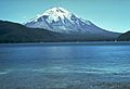
Spirit Lake prior to 1980
-
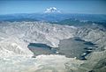
Spirit Lake filled with debris from the eruption. October 4, 1980
-
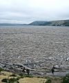
Logs covering Spirit Lake, 2009
-
Spirit Lake
-
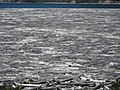
Tree mats on Spirit Lake, 2012
-
Spirit Lake with tree mats and Mount St. Helens
-
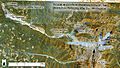
Shows the major changes in hydrology of Mount Saint Helens after its 1980 eruption, including artificial modifications designed to mitigate sediment and water flow.
-
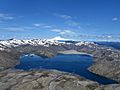
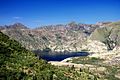
View above Spirit Lake


.jpg)


