Walla Walla County, Washington facts for kids
Quick facts for kids
Walla Walla County
|
||
|---|---|---|

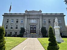
Walla Walla County Courthouse in 2024
|
||
|
||

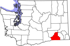
Location within the U.S. state of Washington
|
||
 Washington's location within the U.S. |
||
| Country | ||
| State | ||
| Founded | April 25, 1854 | |
| Named for | Walla Walla people | |
| Seat | Walla Walla | |
| Largest city | Walla Walla | |
| Area | ||
| • Total | 1,299 sq mi (3,360 km2) | |
| • Land | 1,270 sq mi (3,300 km2) | |
| • Water | 29 sq mi (80 km2) 2.2%% | |
| Population
(2020)
|
||
| • Total | 62,584 | |
| • Estimate
(2022)
|
61,890 |
|
| • Density | 46/sq mi (17.8/km2) | |
| Time zone | UTC−8 (Pacific) | |
| • Summer (DST) | UTC−7 (PDT) | |
| Congressional district | 5th | |
Walla Walla County (/ˌwɑːlə ˈwɑːlə/ wah-LƏ-_-WAH-lə) is a county in the southeast part of Washington state. In 2020, about 62,584 people lived here. The main city and county seat is Walla Walla. The county was created on April 25, 1854. It is named after the Walla Walla tribe of Native Americans.
Walla Walla County is part of the Walla Walla, WA Metropolitan Area. This is a group of cities and towns that are connected. In 2020, it was the second smallest metropolitan area in the United States.
Contents
Geography of Walla Walla County
Walla Walla County covers a total area of about 1,299 square miles. Most of this area, about 1,270 square miles, is land. The remaining 29 square miles, or 2.2%, is water.
Rivers and Mountains
Walla Walla County has several important natural features.
- The Columbia River and Snake River flow nearby.
- The Blue Mountains are to the east.
- The Touchet River and Walla Walla River also run through the county.
- You can find Ponderosa Pines trees here.
- The area is sometimes called the "Banana Belt" because of its mild climate.
Main Roads
Neighboring Counties
Walla Walla County shares borders with other counties:
- To the east is Columbia County.
- To the south is Umatilla County in Oregon.
- To the west is Benton County.
- To the northwest is Franklin County.
Protected Natural Areas
Some parts of Walla Walla County are protected.
- McNary National Wildlife Refuge helps protect wildlife.
- Part of the Umatilla National Forest is in the county.
- Whitman Mission National Historic Site is a historical area.
People of Walla Walla County
| Historical population | |||
|---|---|---|---|
| Census | Pop. | %± | |
| 1860 | 1,318 | — | |
| 1870 | 5,300 | 302.1% | |
| 1880 | 8,716 | 64.5% | |
| 1890 | 12,224 | 40.2% | |
| 1900 | 18,680 | 52.8% | |
| 1910 | 31,931 | 70.9% | |
| 1920 | 27,539 | −13.8% | |
| 1930 | 28,441 | 3.3% | |
| 1940 | 30,547 | 7.4% | |
| 1950 | 40,135 | 31.4% | |
| 1960 | 42,195 | 5.1% | |
| 1970 | 42,176 | 0.0% | |
| 1980 | 47,435 | 12.5% | |
| 1990 | 48,439 | 2.1% | |
| 2000 | 55,180 | 13.9% | |
| 2010 | 58,781 | 6.5% | |
| 2020 | 62,584 | 6.5% | |
| 2022 (est.) | 61,890 | 5.3% | |
| U.S. Decennial Census 1790–1960 1900–1990 1990–2000 2010–2020 |
|||
In 2010, there were 58,781 people living in Walla Walla County. There were 21,719 households, which are groups of people living together. About 30.8% of these households had children under 18. The average household had 2.50 people.
Many different groups of people live in the county. About 84.5% of the people were white. About 19.7% of the population was of Hispanic or Latino background. People from German, English, and Irish backgrounds also make up a large part of the population.
Cities and Towns
Walla Walla County has several cities and smaller communities.
Cities
- College Place
- Prescott
- Waitsburg
- Walla Walla (This is the main city and where the county government is located.)
Census-Designated Places
These are areas that are like towns but are not officially incorporated as cities.
Unincorporated Communities
These are smaller communities that are not part of any city or census-designated place.
Schools in the County
Walla Walla County has several school districts. These districts manage the public schools in different areas.
- College Place School District
- Columbia School District
- Dixie School District
- Prescott School District
- Touchet School District
- Waitsburg School District
- Walla Walla Public Schools
See also
 In Spanish: Condado de Walla Walla para niños
 | Roy Wilkins |
 | John Lewis |
 | Linda Carol Brown |


