Franklin County, Washington facts for kids
Quick facts for kids
Franklin County
|
|
|---|---|

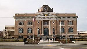
Franklin County Courthouse in Pasco
|
|

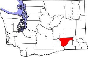
Location within the U.S. state of Washington
|
|
 Washington's location within the U.S. |
|
| Country | |
| State | |
| Founded | November 28, 1883 |
| Named for | Benjamin Franklin |
| Seat | Pasco |
| Largest city | Pasco |
| Area | |
| • Total | 1,265 sq mi (3,280 km2) |
| • Land | 1,242 sq mi (3,220 km2) |
| • Water | 23 sq mi (60 km2) 1.8%% |
| Population
(2020)
|
|
| • Total | 96,749 |
| • Estimate
(2023)
|
99,034 |
| • Density | 76.481/sq mi (29.530/km2) |
| Time zone | UTC−8 (Pacific) |
| • Summer (DST) | UTC−7 (PDT) |
| Congressional districts | 4th, 5th |
Franklin County is a place in the U.S. state of Washington. It's like a big district or region within the state. In 2020, about 96,749 people lived here.
The main city and government center is Pasco. This is also the biggest city in the county. Franklin County was created on November 28, 1883. It was named after Benjamin Franklin, a very important person in American history.
Franklin County is part of a larger area called the Tri-Cities. This area includes the cities of Kennewick, Richland, and Pasco.
Geography of Franklin County
Franklin County covers a total area of about 1,265 square miles. Most of this area is land, about 1,242 square miles. The rest, about 23 square miles, is water.
Important Waterways and Natural Areas
Franklin County has some cool natural spots. These include rivers and special protected areas.
Rivers and Dunes
Protected Areas
Major Roads and Highways
Several important roads run through Franklin County. These highways help people travel and connect different towns.
 SR 260
 Interstate 182
 U.S. 12
 U.S. 395
Neighboring Counties
Franklin County shares its borders with several other counties in Washington.
- Adams County - to the north
- Whitman County - to the east
- Walla Walla County - to the southeast
- Columbia County - to the southeast
- Benton County - to the southwest
- Grant County - to the northwest
Population and People
Franklin County has grown a lot over the years. Many different people call this county home.
| Historical population | |||
|---|---|---|---|
| Census | Pop. | %± | |
| 1890 | 696 | — | |
| 1900 | 486 | −30.2% | |
| 1910 | 5,153 | 960.3% | |
| 1920 | 5,877 | 14.1% | |
| 1930 | 6,137 | 4.4% | |
| 1940 | 6,307 | 2.8% | |
| 1950 | 13,563 | 115.0% | |
| 1960 | 23,342 | 72.1% | |
| 1970 | 25,816 | 10.6% | |
| 1980 | 35,025 | 35.7% | |
| 1990 | 37,473 | 7.0% | |
| 2000 | 49,347 | 31.7% | |
| 2010 | 78,163 | 58.4% | |
| 2020 | 96,749 | 23.8% | |
| 2023 (est.) | 99,034 | 26.7% | |
| U.S. Decennial Census 1790–1960 1900–1990 1990–2000 2010–2020 |
|||
Franklin County has a high percentage of Latino residents. This makes it one of the most diverse counties in Washington state.
Recent Population Numbers
In 2020, the census counted 96,749 people living in Franklin County. There were 28,748 households, which are groups of people living together.
In 2010, there were 78,163 people. The population density was about 63 people per square mile. Many different groups of people live here, making it a diverse place.
The county's population has been growing very fast. From 2010 to 2019, the population increased by 21.8%. This growth is much faster than the rest of Washington state.
Towns and Cities
Franklin County has several cities and smaller communities. These are places where people live and work.
Cities in Franklin County
Other Communities
These are smaller areas where people live. Some are officially recognized places, and others are just small neighborhoods.
Census-Designated Places
Unincorporated Communities
See also
 In Spanish: Condado de Franklin (Washington) para niños
 | Aaron Henry |
 | T. R. M. Howard |
 | Jesse Jackson |

