Columbia County, Washington facts for kids
Quick facts for kids
Columbia County
|
||
|---|---|---|

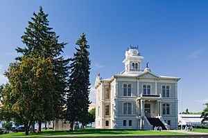
Columbia County Courthouse in Dayton
|
||
|
||

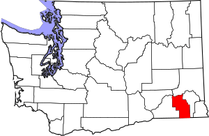
Location within the U.S. state of Washington
|
||
 Washington's location within the U.S. |
||
| Country | ||
| State | ||
| Founded | November 11, 1875 | |
| Named for | Columbia River | |
| Seat | Dayton | |
| Largest city | Dayton | |
| Area | ||
| • Total | 873 sq mi (2,260 km2) | |
| • Land | 869 sq mi (2,250 km2) | |
| • Water | 4.9 sq mi (13 km2) 0.6%% | |
| Population
(2020)
|
||
| • Total | 3,952 | |
| • Estimate
(2023)
|
4,053 |
|
| • Density | 4.6/sq mi (1.8/km2) | |
| Time zone | UTC−8 (Pacific) | |
| • Summer (DST) | UTC−7 (PDT) | |
| Congressional district | 5th | |
Columbia County is a county in the state of Washington. It was created on November 11, 1875. The county is named after the Columbia River, even though the river doesn't flow through it.
In 2020, about 3,952 people lived here. This makes it one of the least populated counties in Washington. The main city and county seat is Dayton. Columbia County is part of the larger Walla Walla area.
Contents
Geography
Columbia County covers about 873 square miles. Most of this area is land, with a small part being water. It is part of a large, rolling prairie-like area called the Palouse. This region is found in the middle of the Columbia River basin.
Geographic features
Major roads
- U.S. Route 12 is an important road here.
Neighboring counties
Columbia County shares borders with several other counties:
- Whitman County to the north
- Garfield County to the east
- Wallowa County, Oregon to the southeast
- Umatilla County, Oregon to the southwest
- Walla Walla County to the west
- Franklin County to the northwest
Protected natural areas
- Part of the Umatilla National Forest is located in Columbia County.
Population Information
| Historical population | |||
|---|---|---|---|
| Census | Pop. | %± | |
| 1880 | 7,103 | — | |
| 1890 | 6,709 | −5.5% | |
| 1900 | 7,128 | 6.2% | |
| 1910 | 7,042 | −1.2% | |
| 1920 | 6,093 | −13.5% | |
| 1930 | 5,325 | −12.6% | |
| 1940 | 5,549 | 4.2% | |
| 1950 | 4,860 | −12.4% | |
| 1960 | 4,569 | −6.0% | |
| 1970 | 4,439 | −2.8% | |
| 1980 | 4,057 | −8.6% | |
| 1990 | 4,027 | −0.7% | |
| 2000 | 4,064 | 0.9% | |
| 2010 | 4,078 | 0.3% | |
| 2020 | 3,952 | −3.1% | |
| 2023 (est.) | 4,053 | −0.6% | |
| U.S. Decennial Census 1790–1960 1900–1990 1990–2000 2010–2020 |
|||
2010 Census details
In 2010, there were 4,078 people living in Columbia County. Most people (93%) were white. About 6.2% of the population was of Hispanic or Latino background.
The average age in the county was about 48.3 years old. There were 1,762 households. About 24.7% of these households had children under 18 living with them.
Towns and cities
City
- Dayton (This is the main city and where the county government is.)
Town
Other communities
Old towns
- Grange City, Washington is now a ghost town.
Education
Schools
Several school districts serve parts of Columbia County:
- Dayton School District
- Pomeroy School District
- Prescott School District
- Starbuck School District
- Waitsburg School District
Library
The Columbia County Rural Library District runs the only public library in the county, located in Dayton. It started in 1919 as a small reading room. Women in the community worked to raise money for a permanent building. In 1937, a public library was built using special funding. It was made bigger in 1947.
In November 2023, there was a community discussion about the future of the rural library district and the library itself. If the district were to close, the library's collection would go to the Washington State Library.
See also
 In Spanish: Condado de Columbia (Washington) para niños
 | Calvin Brent |
 | Walter T. Bailey |
 | Martha Cassell Thompson |
 | Alberta Jeannette Cassell |


