
Dayton, Washington facts for kids
Quick facts for kids
Dayton
|
|
|---|---|
| Dayton, Washington | |

Columbia County Courthouse in Dayton
|
|

Location of Dayton, Washington
|
|
| Country | United States |
| State | Washington |
| County | Columbia |
| Area | |
| • Total | 1.44 sq mi (3.73 km2) |
| • Land | 1.44 sq mi (3.73 km2) |
| • Water | 0.00 sq mi (0.00 km2) |
| Elevation | 1,660 ft (506 m) |
| Population
(2020)
|
|
| • Total | 2,448 |
| • Density | 1,700/sq mi (656.3/km2) |
| Time zone | UTC−8 (Pacific (PST)) |
| • Summer (DST) | UTC−7 (PDT) |
| ZIP code |
99328
|
| Area code(s) | 509 |
| FIPS code | 53-16970 |
| GNIS feature ID | 1504356 |
| Website | City of Dayton |
Dayton is a city in Washington, United States. It is the main town and county seat of Columbia County. In 2020, about 2,448 people lived there.
Contents
Dayton's History
Dayton was started in the 1860s. A couple named Jesse N. and Elizabeth Day officially registered the town on November 23, 1871. The city became an official city on November 10, 1881, and was named after Jesse Day.
Dayton is home to some really old buildings! It has the oldest train station in Washington state, which was built in 1881. It also has the oldest courthouse that has been used without stopping since 1887.
In the 1980s and 1990s, the town spent about $3 million to fix up its historic buildings. They repaired the old train station and courthouse. They also made the main street nicer for people to walk on. Because of these efforts, a special area in Dayton is now recognized as a National Historic Landmark District.
Geography and Climate
Dayton covers about 1.43 square miles (3.73 square kilometers) of land. The Touchet River flows right through the city.
Dayton has a special kind of weather called a Mediterranean climate. This means it has hot summers, but the nights are usually cool and pleasant. Winters are chilly but not too harsh, and there isn't a lot of snow. Dayton's winter weather is often milder than other parts of eastern Washington.
It rains a moderate amount for most of the year. However, from July to September, it's very dry. During this time, big wildfires are common in the area because of the hot days and very dry air.
| Climate data for Dayton, Washington (1991–2020 normals, extremes 1893–present) | |||||||||||||
|---|---|---|---|---|---|---|---|---|---|---|---|---|---|
| Month | Jan | Feb | Mar | Apr | May | Jun | Jul | Aug | Sep | Oct | Nov | Dec | Year |
| Record high °F (°C) | 70 (21) |
74 (23) |
84 (29) |
93 (34) |
101 (38) |
111 (44) |
109 (43) |
114 (46) |
105 (41) |
92 (33) |
80 (27) |
69 (21) |
114 (46) |
| Mean daily maximum °F (°C) | 41.5 (5.3) |
46.2 (7.9) |
53.9 (12.2) |
61.1 (16.2) |
69.9 (21.1) |
76.8 (24.9) |
87.6 (30.9) |
86.7 (30.4) |
77.2 (25.1) |
62.9 (17.2) |
49.3 (9.6) |
40.7 (4.8) |
62.8 (17.1) |
| Daily mean °F (°C) | 34.0 (1.1) |
37.2 (2.9) |
43.4 (6.3) |
49.4 (9.7) |
57.2 (14.0) |
63.4 (17.4) |
71.3 (21.8) |
70.5 (21.4) |
62.2 (16.8) |
50.4 (10.2) |
40.2 (4.6) |
33.6 (0.9) |
51.1 (10.6) |
| Mean daily minimum °F (°C) | 26.4 (−3.1) |
28.2 (−2.1) |
33.0 (0.6) |
37.8 (3.2) |
44.5 (6.9) |
49.9 (9.9) |
54.9 (12.7) |
54.2 (12.3) |
47.2 (8.4) |
38.0 (3.3) |
31.0 (−0.6) |
26.5 (−3.1) |
39.3 (4.1) |
| Record low °F (°C) | −22 (−30) |
−22 (−30) |
2 (−17) |
12 (−11) |
18 (−8) |
22 (−6) |
30 (−1) |
28 (−2) |
18 (−8) |
7 (−14) |
−10 (−23) |
−25 (−32) |
−25 (−32) |
| Average precipitation inches (mm) | 2.08 (53) |
1.72 (44) |
2.24 (57) |
1.86 (47) |
1.80 (46) |
1.24 (31) |
0.39 (9.9) |
0.45 (11) |
0.73 (19) |
1.54 (39) |
2.43 (62) |
2.31 (59) |
18.79 (477) |
| Average snowfall inches (cm) | 6.3 (16) |
1.9 (4.8) |
1.0 (2.5) |
0.1 (0.25) |
0.0 (0.0) |
0.0 (0.0) |
0.0 (0.0) |
0.0 (0.0) |
0.0 (0.0) |
0.1 (0.25) |
1.2 (3.0) |
5.2 (13) |
15.8 (40) |
| Average precipitation days (≥ 0.01 in) | 13.5 | 12.0 | 13.1 | 11.6 | 9.8 | 7.4 | 3.1 | 3.0 | 5.1 | 9.9 | 14.1 | 14.3 | 116.9 |
| Average snowy days (≥ 0.1 in) | 3.4 | 2.4 | 0.9 | 0.1 | 0.0 | 0.0 | 0.0 | 0.0 | 0.0 | 0.1 | 1.0 | 3.6 | 11.5 |
| Source: NOAA | |||||||||||||
People of Dayton
| Historical population | |||
|---|---|---|---|
| Census | Pop. | %± | |
| 1880 | 996 | — | |
| 1890 | 1,880 | 88.8% | |
| 1900 | 2,216 | 17.9% | |
| 1910 | 2,389 | 7.8% | |
| 1920 | 2,695 | 12.8% | |
| 1930 | 2,528 | −6.2% | |
| 1940 | 3,026 | 19.7% | |
| 1950 | 2,979 | −1.6% | |
| 1960 | 2,913 | −2.2% | |
| 1970 | 2,596 | −10.9% | |
| 1980 | 2,565 | −1.2% | |
| 1990 | 2,468 | −3.8% | |
| 2000 | 2,655 | 7.6% | |
| 2010 | 2,526 | −4.9% | |
| 2020 | 2,448 | −3.1% | |
| U.S. Decennial Census 2020 Census |
|||
In 2010, there were 2,526 people living in Dayton. Most people (about 91.6%) were White. About 7.1% of the people were of Hispanic or Latino background.
The average age of people in Dayton was 46.3 years old. About 21.6% of the residents were under 18 years old.
Education and Library
The schools in Dayton are run by the Dayton School District. This district covers most of Columbia County.
Dayton also has a public library. It is the only public library in Columbia County. The library started in 1919 as a small reading room. People raised money to build a permanent library. In 1937, a public library building was built using special government funding. It was made bigger in 1947.
In 2023, there was a plan to close the library completely. This was because of different opinions about some children's books in the library's collection. The plan was stopped by a court ruling in September 2023. The court said the plan was not fair because it did not include all voters in the area.
Famous People from Dayton
- Dmitri Borgmann, a writer
- Frank Finkel, who claimed to be the only person to survive the Battle of the Little Bighorn
- Frederick Gilbreath, a United States Army General
- Robert Shields, who wrote a diary every day
- Jim Watkins, a businessman
Images for kids
-
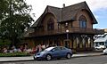
Historic railway depot in Dayton
-
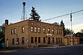
Dayton City Hall


See also
 In Spanish: Dayton (Washington) para niños
