
Touchet River facts for kids
Quick facts for kids Touchet River |
|
|---|---|

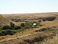
Near Lamar Cabin in autumn
|
|

Location of the mouth of the Touchet River in Washington
|
|
| Country | United States |
| State | Washington |
| County | Walla Walla, Columbia |
| Physical characteristics | |
| Main source | Confluence of North and South forks, Touchet River Dayton, Columbia County 1,671 ft (509 m) 46°18′05″N 117°57′32″W / 46.30139°N 117.95889°W |
| River mouth | Walla Walla River Touchet, Walla Walla County 430 ft (130 m) 46°02′01″N 118°40′59″W / 46.03361°N 118.68306°W |
| Length | 55 mi (89 km) |
| Basin features | |
| Basin size | 740 sq mi (1,900 km2) |
The Touchet River is a 55-mile (89 km) long river in southeastern Washington. It flows into the Walla Walla River.
Long ago, the upper Touchet River was a special summer gathering spot. Native American tribes like the Palus, Nez Perce, and Walla Walla would meet there. They traded goods and played games.
The name Touchet comes from the Sahaptin word Tu-se, which means "roasting." A Nez Perce legend says that a trickster named Coyote roasted salmon at this river. He did this after breaking a fish dam at Celilo that was guarded by seven swallow sisters.
The USGS has also recorded other names for the river, such as Pouchet River and Toosha River.
Contents
Exploring the Touchet River's Geography
The Touchet River basin covers about 740 square miles (1,900 km2). This is the area of land that drains water into the river. The main part of the river is 55 miles (89 km) long.
Where the River Begins and Flows
The Touchet River starts high up in the Blue Mountains. These mountains are part of the Umatilla National Forest in Columbia County. The river begins above the town of Dayton, Washington.
From there, it flows through the towns of Waitsburg and Prescott. Finally, it joins the Walla Walla River near the town of Touchet, Washington.
River Branches and Smaller Streams
The main Touchet River is formed when two smaller rivers, called forks, meet.
- The North Fork of the Touchet starts near the Bluewood Ski Area. It is about 25 miles (40 km) long.
- The South Fork of the Touchet begins at Deadman Peak. It is about 20 miles (32 km) long.
These two forks join together about 2 miles (3 km) south of Dayton. Other smaller streams, called tributaries, also flow into the Touchet River. These include Patit Creek, Coppei Creek, and Whetstone Creek.
Fun Activities on the Touchet River
The Touchet River is a popular spot for fishing. People especially enjoy catching rainbow and cutthroat trout in the upper and middle parts of the river.
Fish and Their Journey
Some fish, like summer steelhead and Chinook salmon, are anadromous. This means they are born in fresh water, travel to the ocean, and then return to the river to lay their eggs (spawn). These fish spawn in many parts of the Touchet River.
However, the number of these fish has become very low in recent years. A dam built in 1905 on the Walla Walla River made it harder for these fish to swim up into the Touchet River. Even so, a group of wild steelhead still returns to the river. These steelhead are listed as a threatened species, meaning they need protection.
A Look Back at Touchet River History
Native American Life Along the River

The Touchet River was part of the traditional lands of the Palus and Walla Walla Native American tribes. These tribes spoke the Sahaptin and lived in the Columbia Plateau region of the northwestern United States.
The river valley provided lots of food for these tribes. They gathered many kinds of roots and berries. Some of these foods included quamash, camas, kouse, bitterroots, serviceberry, chokecherry, huckleberry, gooseberries, wild strawberries, and wild onions.
After 1858, when European immigrants started settling in the area, much of the land used by Native Americans for gathering food was turned into farms.
Before settlers arrived, there was an important Native American trail through the Touchet River valley. It was called the Nez Perce Trail to Celilo Falls. The Nez Perce tribe used this trail to travel west to fish for salmon at Celilo Falls on the Columbia River. Like other Sahaptin-speaking tribes, the Nez Perce moved around, returning to the same places each year. Celilo Falls was at the western end of their yearly travels.
The Lewis and Clark Expedition's Visit
In 1806, on their way back home, the Lewis and Clark Expedition followed the Old Celilo Falls Trail. They traveled up the Walla Walla and Touchet River Valleys. On April 30, 1806, they camped on the Touchet River. This spot was about 12 miles (19 km) north of where the town of Touchet is today.
The Lewis and Clark Trail State Park now marks their campsite from May 1, 1806, on the Touchet River. The expedition then left the Touchet River to follow Patit Creek, a smaller stream, near what is now Dayton. They camped on Patit Creek on May 2, 1806, before continuing their journey.
Early Settlers Arrive
White settlers began moving into the region in 1843. This was helped by the Whitman Mission. In that year, 1,000 people, 120 wagons, and about 5,000 horses and cattle came to the Walla Walla valley. The first settlers stayed near the current city of Walla Walla and also moved into the Touchet River valley.
Later Settlements and Changes

The Lamar Cabin was built in 1863. It was made from cottonwood logs from the Touchet River valley. In 1872, two brothers, James and Joseph Lamar, moved into the cabin. They first raised sheep and horses. Later, like many others in the area, they started growing winter wheat without irrigation.
This area grew into the town of Lamar when the Hunt Railroad was built along the Touchet River valley in 1888. The railway left the Touchet River at Lamar, where the river turns south to meet the Walla Walla. The town of Lamar is now mostly empty, but the old Lamar cabin is still preserved today.
Near the start of the Touchet valley, the town of Dayton officially became a town on November 10, 1881.
Images for kids
-
Near Lamar Cabin in autumn
-
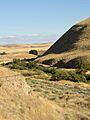
Touchet River Valley in the fall, slightly west of Lamar Cabin.
-
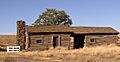
Lamar Cabin
