Prescott, Washington facts for kids
Quick facts for kids
Prescott
|
|
|---|---|

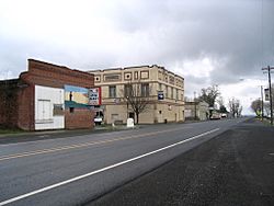
Main intersection in Prescott
|
|

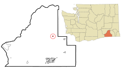
Location of Prescott, Washington
|
|
| Country | United States |
| State | Washington |
| County | Walla Walla |
| Area | |
| • Total | 0.40 sq mi (1.03 km2) |
| • Land | 0.40 sq mi (1.03 km2) |
| • Water | 0.00 sq mi (0.00 km2) |
| Elevation | 1,056 ft (322 m) |
| Population
(2020)
|
|
| • Total | 372 |
| • Density | 930/sq mi (361.2/km2) |
| Time zone | UTC-8 (Pacific (PST)) |
| • Summer (DST) | UTC-7 (PDT) |
| ZIP code |
99348
|
| Area code | 509 |
| FIPS code | 53-56240 |
| GNIS feature ID | 1507623 |
Prescott is a small city located in central Walla Walla County, in the state of Washington. In 2020, about 372 people lived there. It's a quiet place with a rich history.
Contents
Prescott's History
Prescott got its name from C.H. Prescott, who was a railroad official. A post office, which is where you send and receive mail, opened in Prescott way back in 1881. This means people were living and working in the area even then.
The city of Prescott officially became a city on March 13, 1903. This is called being "incorporated," and it means the city could then have its own local government.
Where is Prescott Located?
Prescott is found at specific coordinates: 46.298872 degrees North and -118.314408 degrees West. This helps pinpoint its exact spot on a map.
The United States Census Bureau says that Prescott covers a total area of about 0.40 square miles (1.03 square kilometers). All of this area is land, meaning there are no large lakes or rivers within the city limits.
Prescott's Climate and Weather
Prescott has a type of weather called a semi-arid climate. This means it's usually dry, but not quite a desert. On climate maps, this is often shown as "BSk."
People of Prescott
We can learn a lot about the people living in Prescott from the United States Census Bureau data. The population has changed over the years, growing and shrinking at different times.
| Historical population | |||
|---|---|---|---|
| Census | Pop. | %± | |
| 1890 | 313 | — | |
| 1900 | 657 | 109.9% | |
| 1910 | 502 | −23.6% | |
| 1920 | 559 | 11.4% | |
| 1930 | 275 | −50.8% | |
| 1940 | 324 | 17.8% | |
| 1950 | 244 | −24.7% | |
| 1960 | 269 | 10.2% | |
| 1970 | 242 | −10.0% | |
| 1980 | 341 | 40.9% | |
| 1990 | 267 | −21.7% | |
| 2000 | 314 | 17.6% | |
| 2010 | 318 | 1.3% | |
| 2020 | 372 | 17.0% | |
| U.S. Decennial Census 2015 Estimate |
|||
What the Census Shows
The 2010 census counted 318 people living in Prescott. These people lived in 136 "households," which are like homes or apartments. Out of these, 84 were "families," meaning groups of related people living together.
The city had about 795 people per square mile (307 people per square kilometer). Most of the people in Prescott (almost 90%) were White. About 9.4% of the people were Hispanic or Latino.
In 2010, about 30% of homes had children under 18 living there. Many homes (44.9%) were married couples. The average age of people in Prescott was 44.8 years old. About 23% of residents were under 18, and about 14% were 65 or older. The number of males and females was almost equal.
See also
 In Spanish: Prescott (Washington) para niños
 | Chris Smalls |
 | Fred Hampton |
 | Ralph Abernathy |

