
Waitsburg, Washington facts for kids
Quick facts for kids
Waitsburg, Washington
|
|
|---|---|

Waitsburg in 2019
|
|

Location of Waitsburg, Washington
|
|
| Country | United States |
| State | Washington |
| County | Walla Walla |
| Area | |
| • Total | 1.16 sq mi (3.01 km2) |
| • Land | 1.16 sq mi (3.01 km2) |
| • Water | 0.00 sq mi (0.00 km2) |
| Elevation | 1,263 ft (385 m) |
| Population
(2020)
|
|
| • Total | 1,166 |
| • Density | 1,058.47/sq mi (408.62/km2) |
| Time zone | UTC-8 (Pacific (PST)) |
| • Summer (DST) | UTC-7 (PDT) |
| ZIP code |
99361
|
| Area code | 509 |
| FIPS code | 53-75565 |
| GNIS feature ID | 1512768 |
| Website | City of Waitsburg |
Waitsburg is a small city located in Walla Walla County, Washington, United States. In 2020, about 1,166 people lived there. Waitsburg is special because it is the only city in Washington that still uses its original "territorial charter." This means it follows the rules set up when Washington was still a territory, before it became a state.
The city is found along the Touchet River in a farming area of Southeastern Washington. For a long time, Waitsburg's economy was all about farming, especially grinding wheat into flour. More recently, the city has become known for growing grapes for wine (called viticulture) and for tourism. This is because it is located in the Walla Walla AVA, a famous wine region. The old downtown area, built in the 1880s, is so important that it's listed on the National Register of Historic Places as the Waitsburg Historic District.
History of Waitsburg
Before European American settlers arrived, the land where Waitsburg now stands was home to the Palouse people. The spot where the Touchet River and Coppei Creek meet was even written about in the journals of the Lewis and Clark Expedition in 1806.
Early Settlers and Agreements
Waitsburg was first settled in 1859 by Robert Kennedy. Another early settler, Albert Gallatin Lloyd, helped solve problems with the Palouse people. He made an agreement that allowed the native population to camp on his land. This agreement, though not a formal law, continued until the 1940s.
William Perry Bruce and his wife, Caroline, moved to Waitsburg in 1861. The city was officially formed much later, on November 25, 1881. In 1882, the Bruces built a large house in town. Today, this house is a museum.
Farming and the Gold Rush
Early settlers raised cattle and horses. They also grew grain along the Touchet River and its smaller creeks. In the 1860s, farmers started growing wheat on the nearby hillsides. This led to more wheat production around Waitsburg.
At the same time, gold was found in the Clearwater River valley to the east. This brought many new people to the area. A stagecoach line was set up to connect Walla Walla in the west with Lewiston, Idaho, where the Clearwater and Snake Rivers meet. This stagecoach passed through what would become Waitsburg.
The Mill and Town's Growth
In 1864, Dennis Willard, a landowner in the Waitsburg area, met Sylvester M. Wait in Lewiston. Willard convinced Wait that he could ship wheat flour down the Touchet valley. Wait then built a mill on Willard's land that same year. The city of Waitsburg was later named after Sylvester M. Wait.
.jpeg)
Once the mill was built, a community grew around it. This community included a school, a saloon, a store, a hotel, and a post office. The town was officially mapped out in 1869 and named Waitsburg. By 1870, over 100 people lived in the town, with 35 homes and various businesses. N. J. A. Smith, an early settler and schoolmaster, said Waitsburg was the only important place between Walla Walla and Lewiston.
Waitsburg continued to grow in the 1870s. It was connected by telegraph line to Portland, Oregon, and a newspaper, the Waitsburg Times, was started.
.jpeg)
Fire, Rebuilding, and New Connections
On September 13, 1880, a fire destroyed the town's business district. However, the area was quickly rebuilt, this time using brick. A year later, in 1881, the Oregon Railroad and Navigation Company finished a railroad line through Waitsburg. This connected the city by rail with Walla Walla and the rest of the world.
On November 25, 1881, Waitsburg officially became a city. Its original rules were updated in 1886, and those updated rules have been used ever since. Under these new rules, official city services like police, fire, and utilities began. Waitsburg's importance as a mill town grew throughout the 1880s. The mill, now called Washington Mills, was expanded and improved with new steel machinery. By 1890, Waitsburg's population was over 800 people.
Mill Closure and New Industries
The mill remained the main economic driver for Waitsburg through the late 1800s and into the mid-1900s. In 1936, it changed from using water power to electricity. The electric mill operated for over 20 years, closing in 1957. The empty mill building stood until a fire destroyed it in 2009.
Even after the mill closed, Waitsburg stayed fairly stable. It continued to be a business center for the surrounding farming region throughout the second half of the 20th century.
Since the year 2000, Waitsburg's economy has been boosted by the growing wine industry. The community is part of the Walla Walla AVA, which attracts wine tourists. In the first 20 years of the 21st century, many businesses opened to serve these tourists. These include special restaurants, bars, and hotels. Waitsburg's food scene even received national attention in 2024. Bar Barcello was nominated for a James Beard Award for Best New Restaurant.
Historic Places to Visit
Waitsburg has several buildings and areas listed on the National Register of Historic Places. These places are important because they show the history of the city.
- William Perry Bruce House: This house was built in 1883 by William Perry Bruce, one of Waitsburg's first settlers. It is now the Bruce Memorial Museum.
- Preston Hall: Located at 600 Main Street, this historic building is also listed on the National Register.
- Waitsburg High School: The old high school building at 421 Coopei Street is recognized for its historical importance.
- Waitsburg Historic District: This district covers the main street area of Waitsburg. It includes many of the old buildings that make up the city's downtown.
Geography and Location

Waitsburg covers about 1.12 square miles (3.01 square kilometers) of land. It is located in the valley of the Touchet River in Southeastern Washington. The Touchet River flows along the northern edge of the town. Wilson Creek flows through the eastern part of Waitsburg, and Coppei Creek flows through the western part.
The Touchet River valley is about 1,300 feet (385 meters) above sea level in Waitsburg. The hills around the town rise to about 1,700 feet (518 meters) within a mile to the north and south. The land around Waitsburg has rolling hills covered with farms, mostly growing wheat and barley.
Roads and Highways
Two main roads pass through Waitsburg:
 - U.S. 12: This highway connects Waitsburg to Walla Walla to the west and Dayton to the east.
 - State Route 124: This road comes from the west, connecting Waitsburg to Prescott.
Climate in Waitsburg
Waitsburg has warm, dry summers. The average monthly temperature does not go above 71.6 °F (22 °C). This type of weather is called a "warm-summer Mediterranean climate."
| Climate data for Waitsburg, Washington | |||||||||||||
|---|---|---|---|---|---|---|---|---|---|---|---|---|---|
| Month | Jan | Feb | Mar | Apr | May | Jun | Jul | Aug | Sep | Oct | Nov | Dec | Year |
| Mean daily maximum °C (°F) | 4 (40) |
7 (45) |
12 (53) |
16 (61) |
21 (69) |
25 (77) |
31 (87) |
30 (86) |
24 (76) |
18 (64) |
9 (49) |
5 (41) |
17 (62) |
| Mean daily minimum °C (°F) | −4 (25) |
−2 (29) |
1 (34) |
3 (38) |
7 (44) |
10 (50) |
13 (55) |
12 (54) |
8 (47) |
4 (39) |
0 (32) |
−3 (27) |
4 (39) |
| Average precipitation mm (inches) | 61 (2.4) |
48 (1.9) |
53 (2.1) |
41 (1.6) |
41 (1.6) |
33 (1.3) |
13 (0.5) |
13 (0.5) |
23 (0.9) |
41 (1.6) |
64 (2.5) |
64 (2.5) |
490 (19.3) |
| Source: Weatherbase | |||||||||||||
People of Waitsburg
| Historical population | |||
|---|---|---|---|
| Census | Pop. | %± | |
| 1880 | 248 | — | |
| 1890 | 817 | 229.4% | |
| 1900 | 1,011 | 23.7% | |
| 1910 | 1,237 | 22.4% | |
| 1920 | 1,174 | −5.1% | |
| 1930 | 869 | −26.0% | |
| 1940 | 936 | 7.7% | |
| 1950 | 1,015 | 8.4% | |
| 1960 | 1,010 | −0.5% | |
| 1970 | 953 | −5.6% | |
| 1980 | 1,035 | 8.6% | |
| 1990 | 990 | −4.3% | |
| 2000 | 1,212 | 22.4% | |
| 2010 | 1,217 | 0.4% | |
| 2020 | 1,166 | −4.2% | |
| U.S. Decennial Census | |||
Population in 2010
According to the 2010 census, there were 1,217 people living in Waitsburg. These people lived in 475 households, with 328 of them being families. The city had about 1,086.6 people per square mile. There were 522 housing units, with about 466.1 units per square mile.
Most of the people in Waitsburg were White (93.1%). Other groups included Native American (1.5%), Asian (0.7%), and African American (0.2%). About 5.3% of the population was Hispanic or Latino.
In the 475 households, 37.5% had children under 18 living with them. About 53.3% were married couples. About 10.7% had a female head of household with no husband, and 5.1% had a male head of household with no wife. About 30.9% were not families.
The average household had 2.56 people, and the average family had 3.04 people. The median age in the city was 41 years old. About 26.4% of residents were under 18, and 16.1% were 65 or older. The population was almost evenly split between males (49.6%) and females (50.4%).
Gallery
-
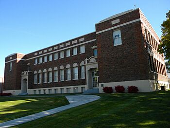
Waitsburg High School
-
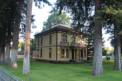
Bruce House
-
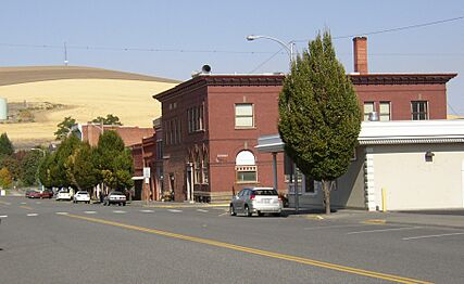
Downtown Waitsburg in 2006
-
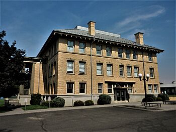
Preston Hall


See also
 In Spanish: Waitsburg (Washington) para niños
