
Eastern Washington facts for kids
Quick facts for kids
Eastern Washington
|
|
|---|---|
|
Geographic region
|
|
| Nickname(s):
Eastside
|
|
 |
|
| Country | United States |
| State | Washington |
| Area | |
| • Total | 46,620 sq mi (120,700 km2) |
| Highest elevation | 12,276 ft (3,742 m) |
| Lowest elevation | 79 ft (24 m) |
| Population
(2019)
|
1,641,900 |
Eastern Washington is a large area in the state of Washington, located in the United States. It is found east of the Cascade Range mountains. This region is home to important cities like Spokane (the state's second-largest city) and the Tri-Cities.
You'll also find the mighty Columbia River and the huge Grand Coulee Dam here. The Yakima Valley and the Palouse area are known for their rich farmlands. Unlike the western part of Washington, Eastern Washington has a very dry climate, with some areas even being deserts!
Contents
Climate in Eastern Washington

The weather in Eastern Washington is quite different from the western part of the state. Western Washington gets a lot of rain because it's close to the ocean. But Eastern Washington gets much less rain. This is because of something called a rain shadow. The tall Cascade Mountains block most of the rain clouds coming from the Pacific Ocean.
Since Eastern Washington is farther from the sea, it has hotter summers and colder winters. Many towns here get a good amount of snow every year. In contrast, snowfall is rare in Western Washington.
Even with these differences, both sides of the state share some weather patterns. They both get more rain in winter than in summer. They also don't have many severe storms. Temperatures are generally milder than in places much farther inland.
The climate can also change within Eastern Washington itself. Lower areas are usually hotter and drier. Higher areas tend to be cooler and get more rain. For example, Richland is at a lower elevation and is hotter. Spokane is higher up and is cooler.
Geography of Eastern Washington
Other Names for the Region
People sometimes use different names for Eastern Washington or parts of it. These names include:
- Columbia Basin
- Eastside or east side of the state
- Inland Empire or Inland Northwest (this name also includes part of Idaho)
Major Cities

Eastern Washington has many cities and towns. Here are some of the largest ones, with over 10,000 people:
- Spokane (population: 217,300)
- Spokane Valley (population: 94,919)
- Yakima (population: 93,701)
- Kennewick (population: 80,280)
- Pasco (population: 71,680)
- Richland (population: 54,150)
- Wenatchee (population: 34,070)
- Walla Walla (population: 33,840)
- Pullman (population: 33,280)
- Moses Lake (population: 22,720)
- Ellensburg (population: 19,550)
- Sunnyside (population: 16,640)
- West Richland (population: 14,660)
- East Wenatchee (population: 13,600)
- Cheney (population: 11,880)
- Grandview (population: 11,170)
Protected Natural Areas

Eastern Washington has many beautiful natural areas that are protected. These include:
- Hanford Reach National Monument
- Lake Roosevelt National Recreation Area
- Juniper Dunes Wilderness
- Salmo-Priest Wilderness
- Wenaha-Tucannon Wilderness (part of it)
There are also several National Forests and Wildlife Refuges:
- Colville National Forest
- Idaho Panhandle National Forest (part of it)
- Kaniksu National Forest (part of it)
- Okanogan–Wenatchee National Forest
- Umatilla National Forest (part of it)
- Columbia National Wildlife Refuge
- Conboy Lake National Wildlife Refuge
- Little Pend Oreille National Wildlife Refuge
- McNary National Wildlife Refuge
- Saddle Mountain National Wildlife Refuge
- Toppenish National Wildlife Refuge
- Turnbull National Wildlife Refuge
- Umatilla National Wildlife Refuge (part of it)
- Crawford State Park
Counties in Eastern Washington
Eastern Washington is made up of many counties. These include: Adams, Asotin, Benton, Chelan, Columbia, Douglas, Ferry, Franklin, Garfield, Grant, Kittitas, Klickitat, Lincoln, Okanogan, Pend Oreille, Spokane, Stevens, Walla Walla, Whitman, and Yakima counties. Some people also include a small part of Skamania County that is east of the Cascade Mountains.
Population
Eastern Washington is about twice as big in land area as Western Washington. However, it has only about one-fifth of the population. In July 2019, about 1,641,900 people lived in Eastern Washington. The number of people growing in both Eastern and Western Washington is about the same.
Education

Eastern Washington is home to many colleges and universities. This includes three of the five public universities in the state.
Public Universities and Colleges
- Central Washington University
- Eastern Washington University
- Washington State University
- Several local community colleges, such as:
- Big Bend Community College
- Columbia Basin College
- Spokane Community College
- Spokane Falls Community College
- Walla Walla Community College
- Wenatchee Valley College
- Yakima Valley College
Private Universities and Colleges
- Gonzaga University
- Heritage University
- Pacific Northwest University of Health Sciences
- Walla Walla University
- Whitman College
- Whitworth University
Research Centers
- Pacific Northwest National Laboratory
- Chimpanzee and Human Communication Institute at Central Washington University
Idea for a New State

Sometimes, people in Eastern Washington have talked about creating a new state. This new state would be made by splitting Washington state down the Cascade Mountains. This idea has been brought up in the state government several times, but it hasn't happened yet.
Some suggested names for this new state include Lincoln, Columbia, or Liberty. The idea behind this is that Eastern Washington often votes for the Republican Party. Western Washington usually votes for the Democratic Party. However, Spokane, the largest city in Eastern Washington, tends to vote more for the Democratic Party. Whitman County also tends to vote Democratic.
Images for kids
-
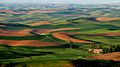
The Palouse Hills of southeastern Washington
-
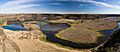
Dry Falls in the semi-desert Channeled Scablands that dominate much of eastern Washington.
-
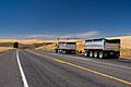
Truck transport going east on Highway 2, near Waterville
-
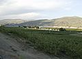
Apple orchards in Azwell, Washington surrounding a community of pickers' cabins


