White Salmon, Washington facts for kids
Quick facts for kids
White Salmon
|
|
|---|---|
| White Salmon, Washington | |

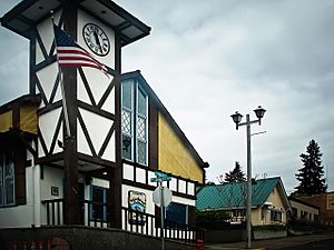
White Salmon City Hall.
|
|
| Nickname(s):
The Land Where The Sun Meets The Rain
|
|
 |
|
| Country | United States |
| State | Washington |
| County | Klickitat |
| Area | |
| • Total | 1.54 sq mi (3.98 km2) |
| • Land | 1.54 sq mi (3.98 km2) |
| • Water | 0.00 sq mi (0.00 km2) |
| Elevation | 623 ft (190 m) |
| Population
(2020)
|
|
| • Total | 2,485 |
| • Density | 1,614/sq mi (624.4/km2) |
| Time zone | UTC-8 (Pacific (PST)) |
| • Summer (DST) | UTC-7 (PDT) |
| ZIP code |
98672
|
| Area code(s) | 509 |
| FIPS code | 53-78330 |
| GNIS feature ID | 1512803 |
| Website | City of White Salmon |
White Salmon is a city in Washington, United States. It is located in Klickitat County. The city sits in the beautiful Columbia River Gorge. In 2020, about 2,485 people lived there.
Contents
A Look at White Salmon's Past
White Salmon was first settled in 1852. Erastus Joslyn and his wife were the first to make their home here. The city officially became a city on June 3, 1907.
Native American History
The land where White Salmon is now was once home to the Klickitat Tribe. They are now part of the Yakama Confederated Nations. The Klickitat Tribe sold some land to the early settlers.
After a conflict called the Yakama War, the area was opened for more settlers in 1858. Many new people quickly moved in. The Klickitat people were then moved to the Yakama Reservation.
How White Salmon Got Its Name
The city of White Salmon was named after the nearby White Salmon River.
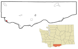
Where is White Salmon Located?
White Salmon is found at coordinates 45.728792 degrees North and -121.483557 degrees West.
City Size and Surroundings
The city covers about 1.22 square miles (3.16 square kilometers) of land. There is no water within the city limits.
White Salmon is located right across the Columbia River from Hood River, Oregon.
White Salmon's Weather
White Salmon has a varied climate. Summers are usually warm and dry. Winters are cool and wet.
Temperature Extremes
- Hottest recorded temperature: 115°F (46°C) in July.
- Coldest recorded temperature: -21°F (-29°C) in February.
Average Temperatures
- Summer (July/August): Highs around 82°F (28°C), lows around 55°F (13°C).
- Winter (December/January): Highs around 40-42°F (4-6°C), lows around 30-31°F (-1°C).
Rainfall
The city gets the most rain in winter. November, December, and January are the wettest months. Summers are much drier.
Who Lives in White Salmon?
| Historical population | |||
|---|---|---|---|
| Census | Pop. | %± | |
| 1910 | 682 | — | |
| 1920 | 619 | −9.2% | |
| 1930 | 798 | 28.9% | |
| 1940 | 985 | 23.4% | |
| 1950 | 1,353 | 37.4% | |
| 1960 | 1,590 | 17.5% | |
| 1970 | 1,585 | −0.3% | |
| 1980 | 1,853 | 16.9% | |
| 1990 | 1,861 | 0.4% | |
| 2000 | 2,193 | 17.8% | |
| 2010 | 2,224 | 1.4% | |
| 2020 | 2,485 | 11.7% | |
| U.S. Decennial Census 2020 Census |
|||
City Population in 2010
In 2010, White Salmon had 2,224 people living in 921 homes. About 559 of these were families.
- Population Density: There were about 1,823 people per square mile.
- Housing: The city had 1,039 housing units.
Diversity in White Salmon
The people living in White Salmon in 2010 were:
- 78.8% White
- 0.3% African American
- 1.4% Native American
- 0.9% Asian
- 14.7% from other backgrounds
- 3.9% from two or more backgrounds
About 24.4% of the people were of Hispanic or Latino heritage.
Households and Families
- About 31.5% of homes had children under 18.
- 45.7% were married couples.
- 10.7% were single mothers.
- 4.2% were single fathers.
- 39.3% were not families.
The average home had 2.41 people. The average family had 3.09 people.
Age of Residents
The average age in White Salmon was 38.1 years old.
- 25.6% of residents were under 18.
- 15.8% were 65 or older.
The city had slightly more females (51.4%) than males (48.6%).
See also
 In Spanish: White Salmon para niños
 | Valerie Thomas |
 | Frederick McKinley Jones |
 | George Edward Alcorn Jr. |
 | Thomas Mensah |

