White Salmon River facts for kids
Quick facts for kids White Salmon River |
|
|---|---|
 |
|
|
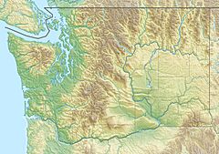
Location of the mouth of the White Salmon River in Washington
|
|
| Country | United States |
| State | Washington |
| County | Klickitat, Skamania |
| Physical characteristics | |
| Main source | Mount Adams Wilderness Gifford Pinchot National Forest, Klickitat County, Cascade Range 5,381 ft (1,640 m) 46°11′10″N 121°35′05″W / 46.18611°N 121.58472°W |
| River mouth | Columbia River Columbia River Gorge near Underwood, Skamania County 79 ft (24 m) 45°43′43″N 121°31′16″W / 45.72861°N 121.52111°W |
| Length | 44.3 mi (71.3 km) |
| Basin features | |
| Basin size | 400 sq mi (1,000 km2) |
| Type: | Wild, Scenic |
| Designated: | November 17, 1986 |
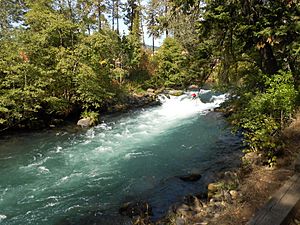
The White Salmon River is a 44-mile long river in Washington state. It starts on the slopes of Mount Adams. The river then flows into the Columbia Gorge near the town of Underwood. Parts of this river are special because they are called "Wild and Scenic." The main streams that flow into the White Salmon River include Trout Lake, Buck Creek, Mill Creek, Dry Creek, Gilmer Creek, and Rattlesnake Creek.
Contents
What Makes the White Salmon River Wild and Scenic?
In 1986, a part of the lower White Salmon River was named "Wild and Scenic." This special area is between Gilmer Creek and Buck Creek. Later, in 2005, more of the river was added to this list. This included the upper river, from where it starts down to the edge of the Gifford Pinchot National Forest.
These two parts of the river are not connected. They add up to about 27.7 miles. About 6.7 miles are considered "wild," meaning they are very natural. The other 22.3 miles are "scenic," offering beautiful views. Near the Trout Lake Farming Community, there are a few small dams. These dams are used for irrigation. They can sometimes block fish like trout from moving freely in the river.
Fun Activities on the White Salmon River
The White Salmon River is a great place for whitewater boating. People can go rafting or kayaking almost all year. A popular starting point is a public area called BZ Corner. This spot has parking, restrooms, and toilets for visitors.
You can also take full-day whitewater trips. These trips go through the area where the Condit Dam used to be. They continue all the way to where the White Salmon River meets the Columbia River. If you want a guided trip, you can find companies that have special permits to lead tours on the river.
The Story of Condit Dam Removal
On October 26, 2011, something big happened on the White Salmon River. The Condit Dam was purposely broken down. This was part of a plan by a company called PacifiCorp to remove the dam. The Condit Dam was 125 feet tall.
In the summer of 2011, workers drilled and blasted a tunnel at the bottom of the dam. The final blast broke the last part of the tunnel wall. The water from the Northwestern Reservoir then drained out in less than an hour. This showed the muddy canyon and an old timber dam below. The summer of 2012 was spent removing the main dam structure. The old Condit Powerhouse is still there. It reminds people that this place once made a lot of electricity. After the dam was removed, the river could flow freely for the first time in almost 100 years.
How Dam Removal Helped Fish
When Condit Dam was built in 1913, it greatly harmed the salmon and steelhead fish in the White Salmon River. Two wooden fish ladders were built early on, but floods washed them away. Fish like Chinook Salmon, Coho Salmon, Steelhead, and Pacific Lamprey could only reach about 3.3 miles of river habitat.
After the dam was fully removed in the fall of 2012, these fish could once again reach 33 miles of excellent habitat. Other projects are still happening to help restore the river. For example, a new culvert was put in on Mill Creek in 2016. This helps fish pass through more easily. All signs show that more salmon and steelhead are returning since the dam was removed.
In 2019, PacifiCorp said they are working with the Yakama Nation. They plan to transfer some land downstream of the former dam to the Yakama Nation. Discussions are also ongoing about the land that was once under Northwestern Lake. They are working with local cabin owners to decide what to do with these lands fairly.
 | Valerie Thomas |
 | Frederick McKinley Jones |
 | George Edward Alcorn Jr. |
 | Thomas Mensah |


