
East Wenatchee, Washington facts for kids
Quick facts for kids
East Wenatchee, Washington
|
||
|---|---|---|

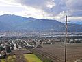
View of the Columbia River from the eastern hills of East Wenatchee
|
||
|
||

Location in the state of Washington
|
||
| Country | United States | |
| State | Washington | |
| County | Douglas | |
| Incorporated | March 11, 1935 | |
| Government | ||
| • Type | Mayor–council | |
| Area | ||
| • Total | 4.10 sq mi (10.61 km2) | |
| • Land | 3.79 sq mi (9.81 km2) | |
| • Water | 0.31 sq mi (0.79 km2) | |
| Elevation | 712 ft (217 m) | |
| Population
(2020)
|
||
| • Total | 14,158 | |
| • Density | 3,453/sq mi (1,334.4/km2) | |
| Time zone | UTC-8 (PST) | |
| • Summer (DST) | UTC-7 (PDT) | |
| ZIP code |
98802
|
|
| Area code | 509 | |
| FIPS code | 53-20155 | |
| GNIS feature ID | 1519148 | |

East Wenatchee is a city located in Douglas County, Washington, USA. It sits on the east side of the Columbia River, right across from the city of Wenatchee.
In 2020, about 14,158 people lived in East Wenatchee. The city has grown a lot over the years, especially since 2000. It's also considered a main city in the larger Wenatchee – East Wenatchee metropolitan area.
Contents
History of East Wenatchee
How the City Began
At the start of the 1900s, new irrigation projects helped the area grow a lot of crops. Fruit orchards became a very important industry.
In 1908, the first highway bridge across the Columbia River opened. This bridge connected Wenatchee on the west side with East Wenatchee on the east side. It allowed people, horses, wagons, and cars to cross, and it also carried water pipes. This bridge helped the apple orchards in Douglas County grow even more.
The bridge was a big idea from W. T. Clark, who helped build a major irrigation canal. It cost $177,000 to build and was partly paid for by James J. Hill, who brought the Great Northern Railway to Wenatchee. The bridge was used until 1950 when a new one, the Senator George Sellar Bridge, was built. Today, the old bridge is a footbridge on the Apple Capital Recreation Loop Trail.
Becoming a City and Growing
On February 28, 1935, the people of East Wenatchee voted to become an official town. The vote was very close! The town officially started on March 11, 1935, and was originally about 50 acres. Over time, it grew much larger through adding more land. Today, East Wenatchee covers about 3.67 square miles. While farming is still important, the city's economy now includes tourism and other businesses.
First Flight Across the Pacific
East Wenatchee made aviation history on October 5, 1931. Two pilots, Clyde Pangborn and Hugh Herndon Jr., landed their plane, Miss Veedol, at a nearby airstrip called Fancher Field. They had flown all the way from Misawa, Japan, making it the first nonstop flight across the Pacific Ocean! To save fuel, they even dropped their landing gear before landing.
To honor this amazing flight, East Wenatchee's airport is now called Pangborn Memorial Airport. There's also a special place called the Pangborn-Herndon Memorial Site nearby, which is listed on the National Register of Historic Places. You can even see Miss Veedol's propeller at the Wenatchee Valley Museum & Cultural Center.
Ancient Discoveries: Clovis Points
On May 27, 1987, East Wenatchee became important in archaeology. Farmworkers digging in an orchard found a hidden collection of 11,000-year-old Clovis points and other tools. These items were left by ancient hunters from the Pleistocene era.
This site, known as the East Wenatchee Clovis Site, is near Pangborn Airport. Scientists studied the site in 1988 and 1990. After some time, new archaeological work was paused, but it was allowed to continue again in 2007.
Geography of East Wenatchee
East Wenatchee is located at 47°25′17″N 120°17′17″W / 47.421506°N 120.288094°W.
The city covers a total area of about 3.81 square miles. Most of this area is land, with only a small part being water.
Climate in East Wenatchee
| Climate data for Pangborn Memorial Airport | |||||||||||||
|---|---|---|---|---|---|---|---|---|---|---|---|---|---|
| Month | Jan | Feb | Mar | Apr | May | Jun | Jul | Aug | Sep | Oct | Nov | Dec | Year |
| Record high °F (°C) | 60 (16) |
65 (18) |
78 (26) |
93 (34) |
103 (39) |
109 (43) |
108 (42) |
109 (43) |
101 (38) |
90 (32) |
70 (21) |
62 (17) |
109 (43) |
| Mean daily maximum °F (°C) | 33.9 (1.1) |
42.2 (5.7) |
53.1 (11.7) |
62.2 (16.8) |
71.3 (21.8) |
78.9 (26.1) |
87.5 (30.8) |
86.2 (30.1) |
76.9 (24.9) |
61.6 (16.4) |
44.3 (6.8) |
33.6 (0.9) |
61.0 (16.1) |
| Mean daily minimum °F (°C) | 22.1 (−5.5) |
27.1 (−2.7) |
33.3 (0.7) |
39.7 (4.3) |
47.2 (8.4) |
54.3 (12.4) |
60.5 (15.8) |
59.9 (15.5) |
51.5 (10.8) |
40.4 (4.7) |
30.6 (−0.8) |
23.2 (−4.9) |
40.8 (4.9) |
| Record low °F (°C) | −12 (−24) |
−15 (−26) |
6 (−14) |
25 (−4) |
32 (0) |
38 (3) |
43 (6) |
42 (6) |
31 (−1) |
15 (−9) |
−5 (−21) |
−21 (−29) |
−21 (−29) |
| Average precipitation inches (mm) | 1.09 (28) |
0.79 (20) |
0.62 (16) |
0.59 (15) |
0.64 (16) |
0.55 (14) |
0.26 (6.6) |
0.31 (7.9) |
0.30 (7.6) |
0.46 (12) |
1.07 (27) |
1.38 (35) |
8.06 (205.1) |
| Average snowfall inches (cm) | 10.3 (26) |
4.3 (11) |
1.6 (4.1) |
0.0 (0.0) |
0.0 (0.0) |
0.0 (0.0) |
0.0 (0.0) |
0.0 (0.0) |
0.0 (0.0) |
0.2 (0.51) |
4.2 (11) |
12.0 (30) |
32.6 (82.61) |
East Wenatchee has a climate with warm summers and cold winters. The hottest month is usually July, and the coldest is January. It doesn't get a lot of rain, but it does get some snow in the winter months.
Economy in East Wenatchee

East Wenatchee is surrounded by many orchards. The main fruits grown here are apples, sweet cherries, and pears. You can also find apricots, peaches, nectarines, and plums. Farmers in the areas outside the city also grow wheat and other grains.
For shopping, the main places are the Wenatchee Valley Mall and Valley North Mall.
Fun Things to Do in East Wenatchee
There are lots of activities to enjoy in East Wenatchee, especially outdoors:
- Skiing: You can go alpine skiing at places like Mission Ridge and Stevens Pass.
- Water Sports: The Columbia River is great for boating, water skiing, and wakeboarding.
- Hiking: Explore many trails and local parks, including the Apple Capital Recreation Loop Trail.
- Kayaking and Rafting: Enjoy paddling on the Columbia or Wenatchee rivers.
- Fishing: There are good spots for fishing.
- Parks: Visit parks by the water like Confluence, Hydro, Walla Walla, and Lincoln parks.
Population of East Wenatchee
| Historical population | |||
|---|---|---|---|
| Census | Pop. | %± | |
| 1940 | 268 | — | |
| 1950 | 389 | 45.1% | |
| 1960 | 383 | −1.5% | |
| 1970 | 913 | 138.4% | |
| 1980 | 1,640 | 79.6% | |
| 1990 | 2,701 | 64.7% | |
| 2000 | 5,757 | 113.1% | |
| 2010 | 13,190 | 129.1% | |
| 2020 | 14,158 | 7.3% | |
| U.S. Decennial Census |
|||
2020 Census Information
According to the 2020 U.S. census, East Wenatchee had 14,158 people living there. There were 5,295 households, which are groups of people living together, and 3,631 families.
The population was made up of different groups:
- About 67.3% were white.
- About 1.5% were Native American.
- About 1.2% were Asian.
- About 31.3% of the population identified as Hispanic or Latino.
- The rest were from other racial backgrounds or identified with two or more races.
About 25.4% of the people were under 18 years old. The average age in the city was 36.4 years.
Education in East Wenatchee
Public schools for students from kindergarten through 12th grade are part of the Eastmont School District #206. The district has several schools in the city:
- Cascade Elementary
- Grant Elementary
- Kenroy Elementary
- Lee Elementary
- Rock Island Elementary
- Clovis Intermediate School
- Sterling Junior High School
- Eastmont Junior High School
- Eastmont High School
Lee Elementary School was originally named after a Confederate general. In 2018, the school district voted to change its name to simply Lee Elementary School.
Getting Around East Wenatchee
Bus Services
Link Transit provides public bus transportation throughout the Wenatchee valley. Their routes connect East Wenatchee with Wenatchee, Leavenworth, Chelan, and Waterville.
Air Travel
The city has its own airport, Pangborn Memorial Airport. You can take daily flights from here to Seattle–Tacoma International Airport with Alaska Airlines.
Roads and Highways
East Wenatchee is connected by several important roads and highways, including State Route 28, State Route 285, U.S. Route 97, and U.S. Route 2.
Notable People from East Wenatchee
- Clyde Ballard, a politician and former state representative.
- Cary Condotta, a politician and former state representative.
- Brad Hawkins, a politician.
- Karla Wilson, a politician and former state representative.
Sister City
East Wenatchee has one sister city, which means it has a special friendly relationship with another city in a different country:
 Misawa, Aomori Prefecture, Japan
Images for kids
-
East Wenatchee, looking northwest, with the Columbia River below.
See also
 In Spanish: East Wenatchee (Washington) para niños
