
Whitman County, Washington facts for kids
Quick facts for kids
Whitman County
|
|
|---|---|

|
|

Location within the U.S. state of Washington
|
|
 Washington's location within the U.S. |
|
| Country | |
| State | |
| Founded | November 29, 1871 |
| Named for | Marcus Whitman |
| Seat | Colfax |
| Largest city | Pullman |
| Area | |
| • Total | 2,178 sq mi (5,640 km2) |
| • Land | 2,159 sq mi (5,590 km2) |
| • Water | 19 sq mi (50 km2) 0.9%% |
| Population
(2020)
|
|
| • Total | 47,973 |
| • Estimate
(2023)
|
48,012 |
| • Density | 22/sq mi (8/km2) |
| Time zone | UTC−8 (Pacific) |
| • Summer (DST) | UTC−7 (PDT) |
| Congressional district | 5th |
Whitman County is a special area called a county in the state of Washington. In 2020, about 47,973 people lived here. The main office, or county seat, is in Colfax. The biggest city in the county is Pullman.
This county was created in 1871 from a larger area called Stevens County. It is named after Marcus Whitman. He was a Presbyterian missionary who, along with his wife Narcissa, sadly died in 1847. They were killed by members of the Cayuse tribe.
Whitman County is also part of the Pullman, Washington Metropolitan Statistical Area. This means it's a region with a big city and nearby areas that are closely connected.
Contents
A Look Back: Whitman County's History
In the early 1800s, both Americans and Canadians started settling in the area that would become Washington state. Canadians were mostly interested in trading furs. Americans, however, wanted land for farming and raising animals.
For a while, both the U.S. and Canadian governments shared control of this land. This shared control often led to arguments. In 1846, the Oregon Treaty finally settled things. It gave the land south of 49 degrees North latitude to American control.
Over time, larger areas were divided into smaller counties. In 1871, a part of Stevens County became Whitman County. Back then, Whitman County was much bigger than it is today! In 1883, parts of Whitman County were used to create Adams, Franklin, and Lincoln counties. After that, Whitman County kept its current shape. Washington became the 42nd state in the U.S. in 1889.
Exploring Whitman County's Geography
Whitman County covers about 2,178 square miles. Most of this is land (2,159 square miles), with a small part (19 square miles) being water. Whitman County is part of a beautiful, rolling area called the Palouse. This region is like a wide prairie in the middle of the Columbia basin.
Rivers Flowing Through Whitman County
Lakes and Reservoirs
- Lake Herbert G. West, formed by the Lower Monumental Dam
- Lake Bryan, named after Dr. Enoch A. Bryan, located behind the Little Goose Dam
- Lower Granite Lake, found behind the Lower Granite Dam
- Rock Lake
Tallest Points: Summits and Peaks
- Tekoa Mountain (about 4,009 feet high)
- Kamiak Butte (about 3,641 feet high)
- Steptoe Butte (about 3,612 feet high)
- Bald Butte (about 3,369 feet high)
Fun Places: Notable Parks
- Steptoe Butte State Park
- Kamiak Butte County Park
- Palouse Falls State Park
- Central Ferry State Park
- Boyer Park and Marina
- Wawawai County Park
Nearby Counties
- Spokane County - north
- Benewah County, Idaho - northeast
- Latah County, Idaho - east
- Nez Perce County, Idaho - southeast
- Asotin County - south/southeast
- Garfield County - south
- Columbia County - south
- Franklin County - southwest
- Adams County - west
- Lincoln County - northwest
Main Roads: Major Highways
 U.S. Route 195
 State Route 23
 State Route 26
 State Route 27
 State Route 127
 State Route 270
 State Route 271
 State Route 272
Airports in Whitman County
- Pullman–Moscow Regional Airport: This airport has flights for passengers and also handles general aviation (smaller planes).
- Port of Whitman Business Air Center Airport: A smaller airport for general aviation, located in Colfax.
People and Population
| Historical population | |||
|---|---|---|---|
| Census | Pop. | %± | |
| 1880 | 7,014 | — | |
| 1890 | 19,109 | 172.4% | |
| 1900 | 25,360 | 32.7% | |
| 1910 | 33,280 | 31.2% | |
| 1920 | 31,323 | −5.9% | |
| 1930 | 28,014 | −10.6% | |
| 1940 | 27,221 | −2.8% | |
| 1950 | 32,469 | 19.3% | |
| 1960 | 31,263 | −3.7% | |
| 1970 | 37,900 | 21.2% | |
| 1980 | 40,103 | 5.8% | |
| 1990 | 38,775 | −3.3% | |
| 2000 | 40,740 | 5.1% | |
| 2010 | 44,776 | 9.9% | |
| 2020 | 47,973 | 7.1% | |
| 2023 (est.) | 48,012 | 7.2% | |
| U.S. Decennial Census 1790–1960 1900–1990 1990–2000 2010–2020 |
|||
In 2010, there were 44,776 people living in Whitman County. About 84.6% of the people were white, 7.8% were Asian, and 1.7% were black or African American. People of Hispanic or Latino origin made up 4.6% of the population.
The average age in the county was 24.4 years old. This is quite young, partly because of the university in the area.
How Whitman County Makes Money: Economy
Whitman County is very good at agriculture. It grows more barley, wheat, dry peas, and lentils than any other county in the United States! This makes farming a huge part of its economy.
The county is also home to Schweitzer Engineering Laboratories in Pullman. This company creates important technology for power systems.
Learning in Whitman County: Education
Pullman is where Washington State University is located. This is a big public university that offers many different study programs.
Places to Live: Communities
Cities
Towns
Special Community: Census-designated place
Small Villages: Unincorporated communities
A Town That's Gone: Ghost town
Gallery
Communities


Geography
-
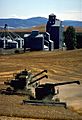
A farm in Whitman County
-
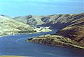
Lower Granite Dam and Boyer Park and Marina on the Snake River
-
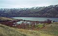
Wawawai County Park


See also
 In Spanish: Condado de Whitman para niños
