Uniontown, Washington facts for kids
Quick facts for kids
Uniontown
|
|
|---|---|
| Uniontown, Washington | |
|
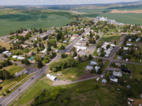
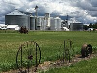
Top: Aerial view of Uniontown in 2023, Bottom: Uniontown grain elevators alongside the highway
|
|
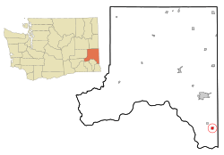
Location of Uniontown, Washington
|
|
| Country | United States |
| State | Washington |
| County | Whitman |
| Settled | 1867 |
| Founded | 1879 |
| Incorporated | 1890 |
| Founded by | Thomas Montgomery |
| Government | |
| • Type | Mayor–council |
| Area | |
| • Total | 0.92 sq mi (2.39 km2) |
| • Land | 0.92 sq mi (2.39 km2) |
| • Water | 0.00 sq mi (0.00 km2) |
| Elevation | 2,582 ft (787 m) |
| Population
(2020)
|
|
| • Total | 389 |
| • Density | 422.8/sq mi (162.8/km2) |
| Time zone | UTC-8 (Pacific (PST)) |
| • Summer (DST) | UTC-7 (PDT) |
| ZIP code |
99179
|
| Area code | 509 |
| FIPS code | 53-73360 |
| GNIS feature ID | 1509182 |
Uniontown is a small town in Whitman County, Washington, United States. In 2020, about 389 people lived there.
Contents
History of Uniontown
Uniontown was first settled in 1867 by Thomas Freeborn Montgomery. He moved west in 1863 to avoid the fighting of the American Civil War.
Montgomery officially claimed land for a home in 1874. He helped Uniontown get its own post office in 1878. People couldn't agree on a town name until 1879. That's when Joseph Cataldo, a Jesuit priest, suggested "Uniontown." This name came from a nearby creek and flat area.
Montgomery was known for being difficult. This caused many problems with local business owners. Some businesses even moved three miles north to the nearby town of Colton. Despite this, Montgomery continued to work in real estate in Uniontown. He passed away in 1883 after a serious disagreement. Uniontown officially became a town in 1890.
Geography of Uniontown
Uniontown is located at 46°32′21″N 117°5′7″W / 46.53917°N 117.08528°W. It is 2,582 feet (787 meters) above sea level.
The town covers about 0.93 square miles (2.39 square kilometers). All of this area is land.
Uniontown's Climate
Uniontown has warm, dry summers. The average monthly temperature never goes above 71.6°F (22°C). This type of weather is called a "warm-summer Mediterranean climate." It is often written as "Csb" on climate maps.
Population and People
| Historical population | |||
|---|---|---|---|
| Census | Pop. | %± | |
| 1890 | 279 | — | |
| 1900 | 404 | 44.8% | |
| 1910 | 426 | 5.4% | |
| 1920 | 404 | −5.2% | |
| 1930 | 360 | −10.9% | |
| 1940 | 332 | −7.8% | |
| 1950 | 254 | −23.5% | |
| 1960 | 242 | −4.7% | |
| 1970 | 310 | 28.1% | |
| 1980 | 286 | −7.7% | |
| 1990 | 277 | −3.1% | |
| 2000 | 345 | 24.5% | |
| 2010 | 294 | −14.8% | |
| 2020 | 389 | 32.3% | |
| Source: U.S. Decennial Census |
|||
Uniontown in 2010
In 2010, Uniontown had 294 people living in 130 households. Most of the people (95.6%) were White. There were also small numbers of Native American, Asian, and people of two or more races. About 1.4% of the population was Hispanic or Latino.
About 21.5% of households had children under 18. Many households (58.5%) were married couples. The average household had 2.26 people.
The average age in town was 44.6 years. About 18.7% of residents were under 18. About 17% were 65 or older. The town had slightly more males (51.4%) than females (48.6%).
Churches in Uniontown
Saint Boniface Catholic Church
Many of Uniontown's first settlers were Swiss and German immigrants. Most of them were Catholic. The first Catholic church in Uniontown was built from wood in 1879. This was the same year the town was officially founded.
Father Anton Joehren, the local Catholic priest, helped a lot in Uniontown's early days. However, like Thomas Montgomery, Father Joehren sometimes had disagreements with people. In 1888, he started planning a large brick and stone church. But construction stopped in 1893 because of a disagreement between the priest and some church members. Only the foundation was built.
Because of problems with Father Joehren, the Benedictine Sisters moved from Uniontown to Colton in 1894. They later built the St. Gertrude Monastery in Cottonwood, Idaho, in 1906.
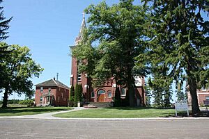
After Father Joehren left, a new priest helped the community build the current church. This church, called St. Boniface Church, was finished in the spring of 1905. It was officially blessed in 1910, making it the first church to be blessed in the state of Washington.
The church was designed by Herman Preusse and Julius Zittel. It is built with bricks in the Romanesque style, which is a type of architecture. It has two towers on the front and a statue of the Blessed Mother on the roof. The church still looks much like it did when it was first built. It has original stained-glass windows, altars, statues, and paintings on the walls. The church has chosen to keep its historic look.
Uniontown Community Church
Uniontown also has a small, non-denominational Christian church. It is run by the people who attend it.
Law Enforcement in Uniontown
Uniontown has a Part-Time Chief of Police. This person provides police services to the town. When the Chief is not working, the Whitman County Sheriff's Office handles calls and law enforcement. The current Chief also works full-time as a police officer in nearby Pullman, Washington. In recent years, many of Uniontown's part-time chiefs have been experienced officers from other police departments.
See also
 In Spanish: Uniontown (Washington) para niños


