Cottonwood, Idaho facts for kids
Quick facts for kids
Cottonwood, Idaho
|
|
|---|---|
 |
|

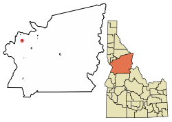
Location of Cottonwood in Idaho County, Idaho.
|
|
| Country | United States |
| State | Idaho |
| County | Idaho |
| Area | |
| • Total | 0.84 sq mi (2.17 km2) |
| • Land | 0.84 sq mi (2.17 km2) |
| • Water | 0.00 sq mi (0.00 km2) |
| Elevation | 3,521 ft (1,073 m) |
| Population
(2010)
|
|
| • Total | 900 |
| • Density | 1,120.38/sq mi (432.45/km2) |
| Time zone | UTC-8 (Pacific (PST)) |
| • Summer (DST) | UTC-7 (PDT) |
| ZIP codes |
83522
|
| Area code(s) | 208 |
| FIPS code | 16-18640 |
| GNIS feature ID | 2410243 |
Cottonwood is a small city in Idaho County, Idaho. It is located in the north central part of the state, on a flat area known as the Camas Prairie. In 2020, about 822 people lived here. The city is just west of U.S. Route 95, a major highway that connects it to towns like Grangeville and Lewiston.
Contents
How Cottonwood Began
Cottonwood started in 1862. It began as simple shelters for gold miners and their suppliers. These travelers were on their way south to places like Florence and Warrens. The city got its name from the many cottonwood trees that used to grow along Cottonwood Creek.
Who Lives in Cottonwood?
| Historical population | |||
|---|---|---|---|
| Census | Pop. | %± | |
| 1910 | 555 | — | |
| 1920 | 610 | 9.9% | |
| 1930 | 519 | −14.9% | |
| 1940 | 673 | 29.7% | |
| 1950 | 689 | 2.4% | |
| 1960 | 1,081 | 56.9% | |
| 1970 | 867 | −19.8% | |
| 1980 | 941 | 8.5% | |
| 1990 | 822 | −12.6% | |
| 2000 | 944 | 14.8% | |
| 2010 | 900 | −4.7% | |
| 2019 (est.) | 940 | 4.4% | |
| U.S. Decennial Census | |||
Population in 2010
According to the census in 2010, there were 900 people living in Cottonwood. These people lived in 363 homes, and 240 of these were families. The city had about 1,071 people per square mile.
Most of the people living in Cottonwood were White (97.1%). A small number were African American, Native American, Asian, or Pacific Islander. About 0.9% of the population identified as Hispanic or Latino.
In 2010, about 31.4% of homes had children under 18. More than half of the homes (52.9%) were married couples. The average age of people in Cottonwood was 43.2 years old. About 26.6% of residents were under 18, and 18.4% were 65 or older.
Geography and Climate
Cottonwood covers an area of about 0.84 square miles (2.17 square kilometers). All of this area is land.
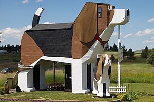
A unique place in Cottonwood is the Dog Bark Park Inn. This is a hotel that is shaped like a giant beagle dog!
Weather in Cottonwood
Cottonwood has a mild climate. This means there isn't a huge difference between the highest and lowest temperatures. It also gets enough rain throughout the year. This type of weather is known as a marine west coast climate.
| Climate data for Cottonwood, Idaho (1991–2020 normals, extremes 1976–present) | |||||||||||||
|---|---|---|---|---|---|---|---|---|---|---|---|---|---|
| Month | Jan | Feb | Mar | Apr | May | Jun | Jul | Aug | Sep | Oct | Nov | Dec | Year |
| Record high °F (°C) | 60 (16) |
64 (18) |
72 (22) |
83 (28) |
86 (30) |
100 (38) |
100 (38) |
103 (39) |
96 (36) |
87 (31) |
68 (20) |
59 (15) |
103 (39) |
| Mean daily maximum °F (°C) | 37.1 (2.8) |
40.2 (4.6) |
47.6 (8.7) |
53.9 (12.2) |
63.0 (17.2) |
69.4 (20.8) |
80.6 (27.0) |
81.4 (27.4) |
72.2 (22.3) |
57.4 (14.1) |
43.6 (6.4) |
35.8 (2.1) |
56.9 (13.8) |
| Daily mean °F (°C) | 30.9 (−0.6) |
33.3 (0.7) |
39.0 (3.9) |
44.5 (6.9) |
52.6 (11.4) |
58.7 (14.8) |
68.3 (20.2) |
68.6 (20.3) |
60.4 (15.8) |
48.0 (8.9) |
36.8 (2.7) |
29.7 (−1.3) |
47.6 (8.7) |
| Mean daily minimum °F (°C) | 24.7 (−4.1) |
26.3 (−3.2) |
30.5 (−0.8) |
35.1 (1.7) |
42.2 (5.7) |
48.1 (8.9) |
56.1 (13.4) |
55.9 (13.3) |
48.7 (9.3) |
38.7 (3.7) |
29.9 (−1.2) |
23.6 (−4.7) |
38.3 (3.5) |
| Record low °F (°C) | −11 (−24) |
−20 (−29) |
4 (−16) |
18 (−8) |
24 (−4) |
32 (0) |
31 (−1) |
32 (0) |
25 (−4) |
8 (−13) |
−5 (−21) |
−18 (−28) |
−20 (−29) |
| Average precipitation inches (mm) | 1.81 (46) |
1.64 (42) |
2.12 (54) |
2.67 (68) |
2.78 (71) |
2.64 (67) |
1.16 (29) |
0.84 (21) |
1.06 (27) |
1.77 (45) |
2.20 (56) |
1.93 (49) |
22.62 (575) |
| Average snowfall inches (cm) | 16.3 (41) |
11.0 (28) |
8.7 (22) |
1.8 (4.6) |
0.3 (0.76) |
0.0 (0.0) |
0.0 (0.0) |
0.0 (0.0) |
0.1 (0.25) |
0.4 (1.0) |
6.3 (16) |
16.5 (42) |
61.4 (156) |
| Average precipitation days (≥ 0.01 in) | 12.6 | 10.9 | 13.0 | 14.8 | 14.8 | 12.2 | 5.5 | 5.2 | 6.1 | 11.0 | 12.9 | 12.7 | 131.7 |
| Average snowy days (≥ 0.1 in) | 8.0 | 5.4 | 4.6 | 1.4 | 0.2 | 0.0 | 0.0 | 0.0 | 0.0 | 0.4 | 3.4 | 9.5 | 32.9 |
| Source: NOAA | |||||||||||||
Getting Around Cottonwood
Main Highways
 - US 95 is the main north-south highway in Idaho. It connects Cottonwood to Lewiston (to the north) and Grangeville (to the south).
This highway used to go right through the center of Cottonwood. However, in 1976, a new bypass road was built east of the city. Now, the main highway goes around Cottonwood.
Railroad Connections
Cottonwood is the end point for the BG&CM Railroad. This is a freight train line that carries goods. It connects Cottonwood to Spalding in the north. This railroad uses old tracks from the Camas Prairie Railroad. The train used to go further south to Fenn and Grangeville, but those tracks were removed in 2003.
Education in Cottonwood
Cottonwood has public schools run by the Cottonwood Joint School District #242. The main school is Prairie Junior/Senior High School, located in Cottonwood. There is also a private Catholic school, St. John Bosco, which teaches students from kindergarten through 12th grade.
Famous People From Cottonwood
Some notable people who have connections to Cottonwood include:
- Don Bies - A former professional golfer on the PGA Tour.
- Teel Bruner - An inductee into the Division III college football hall of fame.
- Sheryl Nuxoll - A former state senator.
- Bobby Watkins - A former professional football player in the NFL.
See also
 In Spanish: Cottonwood (Idaho) para niños
 | Valerie Thomas |
 | Frederick McKinley Jones |
 | George Edward Alcorn Jr. |
 | Thomas Mensah |


