
Grangeville, Idaho facts for kids
Quick facts for kids
Grangeville, Idaho
|
|
|---|---|

Main Street in July 2008
|
|

Location of Grangeville in Idaho County, Idaho.
|
|

Grangeville, Idaho
Location in the United States
|
|
| Country | United States |
| State | Idaho |
| County | Idaho |
| Area | |
| • Total | 1.51 sq mi (3.90 km2) |
| • Land | 1.51 sq mi (3.90 km2) |
| • Water | 0.00 sq mi (0.00 km2) |
| Elevation | 3,399 ft (1,036 m) |
| Population
(2010)
|
|
| • Total | 3,141 |
| • Density | 2,149.40/sq mi (829.70/km2) |
| Time zone | UTC-8 (Pacific (PST)) |
| • Summer (DST) | UTC-7 (PDT) |
| ZIP codes |
83530-83531
|
| Area code(s) | 208 |
| FIPS code | 16-32950 |
| GNIS feature ID | 2410641 |
Grangeville is a city in Idaho, United States. It's the biggest city in Idaho County and also where the county's main offices are located. In 2010, about 3,141 people lived there. The city is in the north central part of Idaho.
Contents
Exploring Grangeville's Location
Grangeville covers about 1.5 square miles of land. It is found on the Camas Prairie, a beautiful grassland. Just south of the city, you can see the mountains of the Nez Perce National Forest.
Roads and Travel
U.S. Route 95 runs along the western edge of Grangeville. This important highway goes north and south through Idaho. Idaho State Highway 13 also starts in Grangeville and goes through the city as Main Street.
Local Airport
The Idaho County Airport is located just north of Grangeville's main business area. It's a public airport owned by the county.
Grangeville's Weather
Grangeville has a humid continental climate. This means it has warm summers and cold, snowy winters.
| Climate data for Grangeville, Idaho (1991–2020 normals, extremes 1893–1906, 1927–present) | |||||||||||||
|---|---|---|---|---|---|---|---|---|---|---|---|---|---|
| Month | Jan | Feb | Mar | Apr | May | Jun | Jul | Aug | Sep | Oct | Nov | Dec | Year |
| Record high °F (°C) | 62 (17) |
69 (21) |
78 (26) |
88 (31) |
96 (36) |
98 (37) |
108 (42) |
106 (41) |
104 (40) |
87 (31) |
72 (22) |
66 (19) |
108 (42) |
| Mean daily maximum °F (°C) | 37.8 (3.2) |
42.0 (5.6) |
49.3 (9.6) |
55.8 (13.2) |
63.8 (17.7) |
70.3 (21.3) |
82.1 (27.8) |
82.5 (28.1) |
72.7 (22.6) |
57.6 (14.2) |
44.9 (7.2) |
37.0 (2.8) |
58.0 (14.4) |
| Daily mean °F (°C) | 31.2 (−0.4) |
33.7 (0.9) |
39.4 (4.1) |
45.1 (7.3) |
52.7 (11.5) |
58.9 (14.9) |
67.9 (19.9) |
67.7 (19.8) |
58.9 (14.9) |
47.0 (8.3) |
37.0 (2.8) |
30.4 (−0.9) |
47.5 (8.6) |
| Mean daily minimum °F (°C) | 24.5 (−4.2) |
25.4 (−3.7) |
29.4 (−1.4) |
34.4 (1.3) |
41.6 (5.3) |
47.5 (8.6) |
53.7 (12.1) |
52.9 (11.6) |
45.1 (7.3) |
36.5 (2.5) |
29.1 (−1.6) |
23.7 (−4.6) |
37.0 (2.8) |
| Record low °F (°C) | −24 (−31) |
−24 (−31) |
−9 (−23) |
11 (−12) |
19 (−7) |
27 (−3) |
33 (1) |
29 (−2) |
19 (−7) |
0 (−18) |
−17 (−27) |
−25 (−32) |
−25 (−32) |
| Average precipitation inches (mm) | 1.27 (32) |
1.43 (36) |
2.31 (59) |
2.90 (74) |
3.44 (87) |
3.26 (83) |
1.07 (27) |
0.90 (23) |
1.30 (33) |
1.93 (49) |
1.91 (49) |
1.79 (45) |
23.51 (597) |
| Average snowfall inches (cm) | 7.9 (20) |
6.2 (16) |
6.0 (15) |
3.2 (8.1) |
0.2 (0.51) |
0.0 (0.0) |
0.0 (0.0) |
0.0 (0.0) |
0.0 (0.0) |
0.6 (1.5) |
5.0 (13) |
9.6 (24) |
38.7 (98) |
| Average precipitation days (≥ 0.01 in) | 9.6 | 8.4 | 11.2 | 13.9 | 12.8 | 11.6 | 5.5 | 4.9 | 5.2 | 9.7 | 11.2 | 10.1 | 114.1 |
| Average snowy days (≥ 0.1 in) | 3.0 | 2.5 | 2.7 | 1.4 | 0.1 | 0.0 | 0.0 | 0.0 | 0.0 | 0.4 | 2.0 | 4.5 | 16.6 |
| Source: NOAA | |||||||||||||
People of Grangeville
| Historical population | |||
|---|---|---|---|
| Census | Pop. | %± | |
| 1880 | 129 | — | |
| 1890 | 540 | 318.6% | |
| 1900 | 1,132 | 109.6% | |
| 1910 | 1,534 | 35.5% | |
| 1920 | 1,439 | −6.2% | |
| 1930 | 1,360 | −5.5% | |
| 1940 | 1,929 | 41.8% | |
| 1950 | 2,544 | 31.9% | |
| 1960 | 3,642 | 43.2% | |
| 1970 | 3,636 | −0.2% | |
| 1980 | 3,666 | 0.8% | |
| 1990 | 3,226 | −12.0% | |
| 2000 | 3,228 | 0.1% | |
| 2010 | 3,141 | −2.7% | |
| 2019 (est.) | 3,237 | 3.1% | |
| U.S. Decennial Census | |||
In 2010, there were 3,141 people living in Grangeville. The city had 1,389 households. Most people living there were White (94.8%). There were also smaller groups of Native American, Asian, and African American residents. About 3.6% of the population was Hispanic or Latino.
The average age in Grangeville was 44 years old. About 23% of residents were under 18. About 20% were 65 years or older.
Fun and Culture in Grangeville
.jpg)
Grangeville has a big yearly celebration called "Border Days." It happens around July 4th, which is Independence Day. This event includes Idaho's oldest rodeo. There are also parades, art shows, and a very large egg toss game!
Learning in Grangeville
Public schools in Grangeville are part of the Mountain View School District #244. The main school is Grangeville High School, located at the south end of the city.
Famous People from Grangeville
Many interesting people have connections to Grangeville:
- Skip Brandt – A former state senator in Idaho.
- George Cowgill – An expert in old cultures of Central America.
- Warren Cowgill – A language expert who studied how ancient languages developed.
- Matt Hill – A professional football player who played in the NFL.
- Len Jordan – He was the governor of Idaho and later a U.S. senator.
- Charlotte May Pierstorff – A young girl famous for being sent through the mail as a package in 1914!
- Larry Ramos – A Grammy award-winning singer, known for being in the 1960s pop band the Association.
- Ken Schrom – A professional baseball pitcher who played in Major League Baseball. He was born and grew up in Grangeville.
Images for kids
-
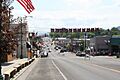
Main Street in July 2008
-
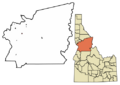
Location of Grangeville in Idaho County, Idaho.
-
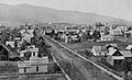
Grangeville, circa 1910
See also
 In Spanish: Grangeville (Idaho) para niños
