
Benewah County, Idaho facts for kids
Quick facts for kids
Benewah County
|
||
|---|---|---|

Benewah County Courthouse
|
||
|
||

Location within the U.S. state of Idaho
|
||
 Idaho's location within the U.S. |
||
| Country | ||
| State | ||
| Founded | January 23, 1915 | |
| Seat | St. Maries | |
| Largest city | St. Maries | |
| Area | ||
| • Total | 784 sq mi (2,030 km2) | |
| • Land | 777 sq mi (2,010 km2) | |
| • Water | 7.3 sq mi (19 km2) 0.9% | |
| Population
(2020)
|
||
| • Total | 9,530 | |
| • Estimate
(2023)
|
10,369 |
|
| • Density | 12.156/sq mi (4.693/km2) | |
| Time zone | UTC−8 (Pacific) | |
| • Summer (DST) | UTC−7 (PDT) | |
| Congressional district | 1st | |

Benewah County is a place in the northwest part of Idaho. It's called a "county," which is like a region or district within a state. In 2020, about 9,530 people lived here.
The main city and county seat is St. Maries. Some parts of St. Maries are inside the Coeur d'Alene Reservation. Benewah County was created on January 23, 1915. It was formed from land that used to be part of Kootenai County. The county was named after a chief of the Coeur d'Alene Tribe. The Coeur d'Alene Tribe is a recognized Native American tribe. Their main home is on the Coeur d'Alene Reservation, which is in Benewah County and nearby Kootenai County.
Contents
Where is Benewah County?
Benewah County is on the western edge of Idaho. Its western border touches the state of Washington. The county covers about 784 square miles (2,031 square kilometers). Most of this area is land, with a small part being water.
This county is part of a larger area called the Palouse. The Palouse is a wide, rolling area that looks like a prairie. It's located in the middle of the Columbia River basin.
Neighboring Counties
Benewah County shares its borders with these other counties:
- Spokane County, Washington – to the northwest
- Kootenai County – to the north
- Shoshone County – to the east
- Latah County – to the south
- Whitman County, Washington – to the southwest
Main Roads and Highways
Several important roads run through Benewah County:
 – US 95
 – SH-3
 – SH-5
 – SH-6
 – SH-58
 – SH-60
Protected Natural Areas
Benewah County has parts of a national forest and some state parks:
- St. Joe National Forest (part of it is in the county)
- Heyburn State Park
- McCroskey State Park
How Many People Live Here?
| Historical population | |||
|---|---|---|---|
| Census | Pop. | %± | |
| 1920 | 6,997 | — | |
| 1930 | 6,371 | −8.9% | |
| 1940 | 7,332 | 15.1% | |
| 1950 | 6,173 | −15.8% | |
| 1960 | 6,036 | −2.2% | |
| 1970 | 6,230 | 3.2% | |
| 1980 | 8,292 | 33.1% | |
| 1990 | 7,937 | −4.3% | |
| 2000 | 9,171 | 15.5% | |
| 2010 | 9,285 | 1.2% | |
| 2020 | 9,530 | 2.6% | |
| 2023 (est.) | 10,369 | 11.7% | |
| US Decennial Census 1790–1960 1900–1990 1990–2000 2010–2020 |
|||
In 2010, there were 9,285 people living in Benewah County. These people lived in 3,837 households. About 86.6% of the people were white, and 8.7% were Native American. Other groups made up smaller parts of the population.
The average age of people in the county was about 44.8 years old. The average income for a family was around $41,759 per year. About 15.2% of all people in the county lived below the poverty line. This means they had a lower income than what is needed to meet basic needs.
Towns and Communities
Benewah County has several cities and smaller communities:
Cities
Census-Designated Places
These are areas that are like towns but are not officially incorporated as cities:
Other Communities
These are smaller, unincorporated places in the county:
- Alder Creek
- Benewah
- Cardwell
- Chatcolet
- Emida
- Flat Creek
- Hawleys Landing
- Lotus
- Mashburn
- Meadowhurst
- Miltown
- Mowry
- North South Ski Bowl
- Omega
- Pedee
- Plummer Junction
- Ramsdell
- Renfrew
- Riverdale
- Rocky Point
- Rover
- Saint Joe
- Sanders
- Santa
- Silvertip Landing
- Tyson Creek Station
- Wayland
- Willard
Schools and Education
Benewah County has several school districts that serve its students:
- Kootenai Joint School District 274
- Plummer-Worley Joint School District 44
- St. Maries Joint School District 41
The county is also in the area for North Idaho College. This means students from Benewah County can attend the college.
Images for kids
-
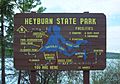
Heyburn State Park information sign
-
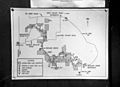
Map of McCroskey State Park


See also
 In Spanish: Condado de Benewah para niños
