
Steptoe, Washington facts for kids
Quick facts for kids
Steptoe
|
|
|---|---|

Overview of Steptoe, Washington
|
|

Steptoe, Washington
Location in Washington (state)

Steptoe, Washington
Location in the United States

Steptoe, Washington
Location in North America
|
|
| Country | United States |
| State | Washington |
| County | Whitman |
| Elevation | 2,316 ft (706 m) |
| Time zone | UTC-8 (Pacific (PST)) |
| • Summer (DST) | UTC-7 (PDT) |
| ZIP code |
99111
|
| Area code | 509 |
| GNIS feature ID | 1508723 |
Steptoe is a small, rural community in Whitman County, Washington, United States. It's an unincorporated area, which means it doesn't have its own local government like a city or town. The special code for mail in Steptoe is 99111.
Contents
Welcome to Steptoe!
Steptoe is a quiet place located in the beautiful state of Washington. It's known for its peaceful countryside and connection to history. This small community offers a glimpse into rural life in the United States.
Where is Steptoe?
Steptoe is found in Whitman County, which is in the eastern part of Washington state. It sits at an elevation of about 2,316 feet (706 meters) above sea level. The area is surrounded by rolling hills and vast farmlands.
What's in a Name?
The community of Steptoe got its name from a famous person: Colonel Edward Steptoe. He was a military officer. A post office was opened here in 1875, helping the community grow. The name also remembers an important battle that happened north of Steptoe, near a town called Rosalia.
Roads and Landmarks
A main road, U.S. Route 195, goes right through Steptoe. This road connects Steptoe to other important places. For example, it leads 11 miles south to Colfax, which is the main town for Whitman County. It also goes 43 miles north to Spokane, the biggest city in the region.
Just four miles northeast of Steptoe, you can see a special landmark called Steptoe Butte. This is a tall hill that rises more than 1,000 feet above the flat land around it. The area is part of the Palouse, which is famous for its beautiful, rolling grasslands.
Images for kids
-
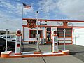
A classic Phillips 66 gas station in Steptoe, Washington.

See also
 In Spanish: Steptoe (Washington) para niños
