
National Register of Historic Places listings in Whitman County, Washington facts for kids
The National Register of Historic Places (NRHP) is like a special list of important buildings, places, and objects in the United States. These places are chosen because they have a lot of history, special architecture, or are important to how our country developed. When a place is on this list, it means it's recognized as a valuable part of our past and should be protected.
Whitman County, Washington, has many amazing places on the National Register. These sites tell stories about the people who lived here long ago, how they worked, and what their communities were like. Let's explore some of these cool historic spots!
Contents
Historic Buildings in Whitman County
Many of Whitman County's historic places are old buildings that show us how people lived and worked in the past.
Old Mills and Farms
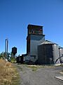
- J. C. Barron Flour Mill: Located in Oakesdale, this old flour mill was built a long time ago. Mills like this were super important because they turned grain into flour, which was a basic food for everyone. It shows us how food was made before big factories.
- Canyon Grain Bin and Chutes: Near Hay, this site reminds us of the huge role farming plays in Whitman County. Grain bins were used to store crops like wheat, and chutes helped move them. It's a peek into the history of agriculture.
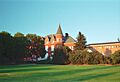
- Collins House and Granary: Found southeast of Uniontown, this property includes a house and a granary. A granary is a building specifically for storing grain. This site, also known as the O. M. Collins House, helps us understand what early farm life was like.
- Gustave Heilsberg Farm: This historic farm near Colfax gives us a glimpse into the farming methods and lifestyle of early settlers in the area.
- McGregor Ranch: Located south of Hooper, this ranch is another important historic farming site. Ranches were central to the economy and daily life in many parts of Washington.
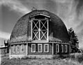
- Max Steinke Barn: In St. John, this barn is a great example of the kind of buildings farmers used. Barns were essential for housing animals and storing crops and equipment.
- Tekoa Grain Company Elevator & Flathouse: West of Lone Pine, this grain elevator and flathouse were crucial for handling and storing grain before it was shipped out. They show the scale of farming operations in the past.
Homes of Important People
- Florence Ferguson House: This house in Colfax is a historic home that tells a story about the people who lived there and their contributions to the community.
- Edwin H. Hanford House: Located north of WA 217 in Oakesdale, this house is another example of a historic residence. It helps us imagine the lives of families from earlier times.
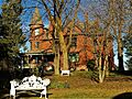
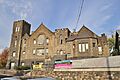
- R. C. McCroskey House: In Garfield, this house was the home of R. C. McCroskey, an important person in the area's history. Learning about his home helps us understand his life and times.
- James A. Perkins House: This historic home in Colfax is another example of the beautiful and important houses built in the past.
- William Swain House: Found on Main Street in Pullman, this house is a historic building that adds to the rich history of the city.
Community Hubs and Public Buildings
Many historic places were once important gathering spots or public services for the community.
Theaters and Churches
- Cordova Theater: In Pullman, the Cordova Theater was once a popular place for entertainment. Theaters like this were where people went to watch movies, plays, and other performances. It's a reminder of how people spent their free time.
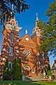
- Holy Trinity Episcopal Church: This church in Palouse is a beautiful example of historic religious architecture. Churches often served as community centers and places of worship.
- St. Boniface Church, Convent and Rectory: In Uniontown, this group of buildings includes a church, a convent (where nuns lived), and a rectory (where a priest lived). They represent an important part of the community's spiritual and social life.
- United Presbyterian Church: This church in Pullman is another historic religious building. Churches often have unique architectural styles and long histories within their communities.
City and Government Buildings
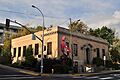
- Central Service Station: Located in Rosalia, this old service station is a historic example of early roadside businesses. It shows how transportation and services developed.
- Masonic Hall: In Farmington, the Masonic Hall was a meeting place for a fraternal organization called the Masons. These halls were often important social centers in small towns.
- Oakesdale City Hall: This building in Oakesdale served as the center of local government. City halls are where important decisions were made and community events often took place.
- U.S. Post Office – Colfax Main: The main post office in Colfax is a historic building that was once the hub for mail and communication.
- U.S. Post Office – Pullman: Similarly, the old post office in Pullman played a vital role in connecting people through letters and packages.
Historic Districts and Bridges
Some historic places are not just single buildings, but entire areas or important structures like bridges.
Historic Districts
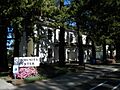
- College Hill Historic District: In Pullman, this district includes a group of historic buildings. Historic districts are areas where many buildings together tell a story about a certain time period or architectural style.
- Palouse Main Street Historic District: This district in Palouse includes many historic buildings along Main Street. It gives us a picture of what a busy town center looked like in the past.
Bridges and Roads
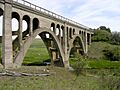
- F Street Bridge: This bridge spans the Palouse River in Palouse. Historic bridges are important examples of engineering from their time.
- Manning-Rye Covered Bridge: Also known as the Harpole Bridge, this covered bridge spans the Palouse River near Colfax. Covered bridges are quite rare and beautiful, protecting the wooden structure from the weather.
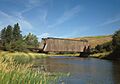
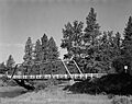
- Rosalia Railroad Bridge: This railroad bridge in Rosalia is a historic structure that was part of the railway system, which was vital for transporting goods and people.
- Star Route and Palouse Street Brick Road: In Pullman, parts of NE Maple and Palouse streets are made of brick! This historic road shows us how streets were built before asphalt became common.
University Buildings
Some historic places are found on the campus of Washington State University in Pullman.
- Stevens Hall: Located on the campus of Washington State University in Pullman, Stevens Hall is a historic building that has been part of the university's growth and education for many years.
- Albert W. Thompson Hall: Another historic building on the Washington State University campus, Thompson Hall has also played a role in the university's history and the education of its students.
Battlefield Site
- Steptoe Battlefield Site: Southeast of Rosalia, this site marks a significant historical event. Battlefields are important for remembering past conflicts and understanding their impact on the region.
Former Historic Listings
Sometimes, places are removed from the National Register of Historic Places. This can happen for different reasons, like if a building is changed too much or is no longer there.
- Elberton Historic District: This district near Elberton was once on the list but was later removed.
- McClure Bridge: This bridge over the Palouse River near Palouse was also delisted from the National Register.
These historic places in Whitman County help us connect with the past and understand the rich history of Washington State!
Images for kids
-
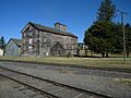
The J. C. Barron Flour Mill in Oakesdale.
-
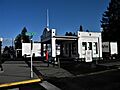
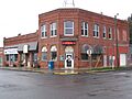
The historic Central Service Station in Rosalia.
-
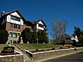
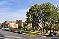
A building in the College Hill Historic District in Pullman.
-
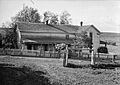
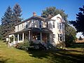
The historic Collins House.
-
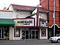
The Cordova Theater in Pullman.
-
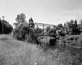
The F Street Bridge over the Palouse River.
-
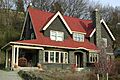
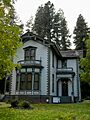
The Florence Ferguson House in Colfax.
-
The Edwin H. Hanford House in Oakesdale.
-
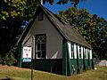
Holy Trinity Episcopal Church in Palouse.
-
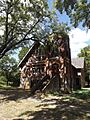
The T. A. Leonard Barn.
-
The Manning-Rye Covered Bridge.
-
The Masonic Hall in Farmington.
-
The R. C. McCroskey House in Garfield.
-
Oakesdale City Hall.
-
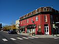
Buildings in the Palouse Main Street Historic District.
-
The James A. Perkins House in Colfax.
-
The old Pullman High School.
-
The Rosalia Railroad Bridge.
-
St. Boniface Church, Convent and Rectory in Uniontown.
-
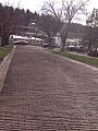
A view of the historic brick road on NE Maple Street in Pullman.
-
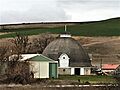
The Max Steinke Barn.
-
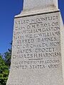
A monument at the Steptoe Battlefield Site.
-
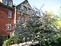
Stevens Hall at Washington State University.
-
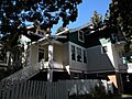
The William Swain House in Pullman.
-
The Tekoa Grain Company Elevator.
-
Albert W. Thompson Hall at Washington State University.
-
The former United Presbyterian Church in Pullman.
-
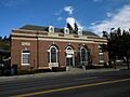
The U.S. Post Office – Colfax Main.
-
The old U.S. Post Office – Pullman.
-
The Elberton Community Church, part of a former historic district.
-
The McClure Bridge, a former historic listing.


.jpg)


.jpg)
See also
- National Register of Historic Places listings in Washington state
- Listings in neighboring counties: Adams, Asotin, Benewah, Columbia, Franklin, Garfield, Latah, Lincoln, Nez Perce, Spokane
- Historic preservation
- History of Washington (state)
- Index of Washington-related articles
External links
- Washington Department of Archaeology and Historic Preservation, Historic Register program
- National Park Service, National Register of Historic Places site
