
National Register of Historic Places listings in Benewah County, Idaho facts for kids

Have you ever wondered about the oldest and most special places in your community? In Benewah County, Idaho, there's a list of important spots called the National Register of Historic Places. This list helps protect buildings, sites, and objects that are important to American history. It's like a hall of fame for historic places!
These places are chosen because they tell us stories about the past. They might be old buildings, parks, or even roads that were built a long time ago. Benewah County has 9 amazing places on this list. Let's explore some of them!
Contents
- Cool Historic Places in Benewah County, Idaho
- Benewah County Courthouse: A Place for Justice
- Chatcolet CCC Picnic and Camping Area: Nature's Getaway
- Coeur d'Alene Mission of the Sacred Heart: A Place of Faith
- Kootenai Inn: A Historic Hotel
- Mullan Road: An Old Trailblazer
- Plummer Point CCC Picnic and Hiking Area: Another CCC Gem
- Rocky Point CCC Properties: More CCC History
- St. Maries 1910 Fire Memorial: Remembering a Big Event
- St. Maries Masonic Temple No. 63: A Community Building
- Images for kids
Cool Historic Places in Benewah County, Idaho
Benewah County Courthouse: A Place for Justice
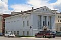
The Benewah County Courthouse is a very important building in St. Maries, Idaho. It's where local government happens and where many important decisions for the county are made. This courthouse was added to the National Register of Historic Places on September 22, 1987. It's a great example of historic architecture in the area.
Chatcolet CCC Picnic and Camping Area: Nature's Getaway
Located in Heyburn State Park near Chatcolet, Idaho, the Chatcolet CCC Picnic and Camping Area is a special outdoor spot. The "CCC" stands for the Civilian Conservation Corps, a group of young men who worked on public projects during the Great Depression. They helped build many parks and outdoor areas. This picnic and camping area was recognized on February 1, 1995, for its historical importance and natural beauty.
Coeur d'Alene Mission of the Sacred Heart: A Place of Faith
The Coeur d'Alene Mission of the Sacred Heart was once a significant site near De Smet, Idaho. It was added to the National Register on April 21, 1975. Sadly, the main building was destroyed by a fire in 2011. Even though the building is gone, its history and what it meant to the community are still remembered.
Kootenai Inn: A Historic Hotel
The Kootenai Inn was a historic hotel located in St. Maries, Idaho. It was listed on the National Register of Historic Places on November 16, 1979. This building was an important part of the town's history, offering a place for travelers and locals to stay. Unfortunately, the building no longer exists today, but its memory lives on through its historic listing.
Mullan Road: An Old Trailblazer
The Mullan Road is a very old and important road that passes through the St. Maries, Idaho area. It was one of the first military roads built in the Pacific Northwest, connecting different parts of the region. This historic road was added to the National Register on April 5, 1990. It reminds us of how people traveled and explored the land a long time ago. Parts of this road also extend into Kootenai County.
Plummer Point CCC Picnic and Hiking Area: Another CCC Gem
Just like the Chatcolet area, the Plummer Point CCC Picnic and Hiking Area is also found in Heyburn State Park near Chatcolet, Idaho. This area was also built by the Civilian Conservation Corps. It was recognized on February 1, 1995, for its role in providing outdoor recreation and for the historical work done by the CCC. It's a great place for picnics and hikes!
Rocky Point CCC Properties: More CCC History
Still in Heyburn State Park near Chatcolet, Idaho, the Rocky Point CCC Properties are another set of sites built by the Civilian Conservation Corps. These properties were added to the National Register on February 1, 1995. They show the amazing work the CCC did to develop parks and outdoor spaces for everyone to enjoy.
St. Maries 1910 Fire Memorial: Remembering a Big Event
The St. Maries 1910 Fire Memorial is a monument located in the St. Maries Cemetery in St. Maries, Idaho. This memorial remembers the devastating 1910 fires that swept through North Idaho. These fires were some of the largest in American history. The memorial was listed on the National Register on September 20, 1984, honoring those affected by this huge event.
St. Maries Masonic Temple No. 63: A Community Building
The St. Maries Masonic Temple No. 63 is a historic building in St. Maries, Idaho. It was added to the National Register of Historic Places on September 23, 2011. This building has served as a meeting place for the Masonic Lodge, an organization focused on community service and fellowship. It's an important part of the town's social history.
Images for kids
-
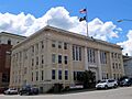
The Benewah County Courthouse in St. Maries.
-
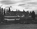
The Coeur d'Alene Mission of the Sacred Heart before the 2011 fire.
-
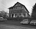
The Kootenai Inn in 1978.
-
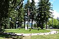
The St. Maries 1910 Fire Memorial.
-
The St. Maries Masonic Temple No. 63.


