
Mullan Road facts for kids
Quick facts for kids |
|
|
Mullan Road
|
|

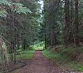
Looking north at one of the few remaining gravel stretches of the Mullan Road as it crosses Washington State Route 26 near Washtucna, Washington. The portion south of SR 26 has reverted to grazing.
|
|
| Nearest city | St. Maries, Idaho Coeur d'Alene, Idaho Mullan, Idaho St. Regis, Montana Missoula, Montana Helena, Montana Great Falls, Montana |
|---|---|
| Built | 1853, 173 years ago |
| NRHP reference No. | 90000548 |
| Added to NRHP | April 5, 1990 |
The Mullan Road was the very first wagon road that crossed the mighty Rocky Mountains. It helped connect the eastern parts of the United States with the Pacific Northwest. This important road was built by soldiers from the United States Army.
Lieutenant John Mullan led the team that built the road. Construction happened between the spring of 1859 and the summer of 1860. The road started at Fort Benton, Montana, which was a very important port on the Missouri River. It ended at Fort Walla Walla, near the Columbia River.
The Mullan Road followed a path similar to parts of today's Interstate 15 and Interstate 90. These modern highways now go through Montana, Idaho, and Washington. You can still travel on some parts of the Mullan Road today, like a section near Washtucna, Washington.
Several parts of the Mullan Road are recognized as historic places. A section near Benton Lake was added to the National Register of Historic Places in 1975. The American Society of Civil Engineers also named it a National Historic Civil Engineering Landmark in 1977. Three parts of the road in Idaho were listed in 1990. More recently, in 2009, the Point of Rocks section in Montana was also added to the National Register.
Contents
Building the Mullan Road: A Historic Journey

As early as 1852, the U.S. government started thinking about building a land route to the Pacific Ocean. They wanted to help American pioneers settle the western lands. This would also help secure the areas that other countries like France, England, and Russia had once claimed.
Even after the famous Lewis and Clark expedition, not much was known about the western lands. So, Isaac Stevens, who became the first governor of the Washington Territory, was asked to survey a route. His main job was to find a good path for a railroad. However, he also kept in mind that the route should work for wagons too.
The Expedition Begins
In the spring of 1853, the U.S. Congress approved a special expedition. Isaac Stevens led this group, which included engineers and explorers. They started their journey near Saint Paul, Minnesota. Their goal was to map out the land's features and shape.
Among the team was a young man named Lieutenant John Mullan. He had just graduated from West Point a year earlier. He was very eager to show his skills as an engineer.
Lieutenant Mullan's Role
Lieutenant Mullan was put in charge of surveying and improving the wagon route. This route is now famously known as the Mullan Road. It stretched between Fort Benton, Montana and Fort Walla Walla in Washington. Mullan, a skilled topographical engineer, began gathering information in 1854.
Construction of the road was delayed by the Yakima War, which ended in 1858. Work finally began in 1859, starting from Fort Walla Walla in the Washington Territory. Lieutenant Mullan led a large team of over 200 people. This group included civilian workers, surveyors, engineers, and soldiers. Together, they carved a road that was about 25 feet (7.6 meters) wide across the region.
Challenges and Importance
The project was very difficult, but it was completed in 1860. However, soon after, large floods washed away big parts of the road. It had to be re-routed in 1861. More floods damaged the road again, and unfortunately, no plans were made to keep it repaired.
Even though the military didn't use the road much, it was very important for regular people. It helped speed up the settlement of the northwestern United States. In its first year, about 20,000 people used the road. They traveled with 6,000 horses and mules, 5,000 cattle, and 83 wagons.
The discovery of gold in North Central Idaho in 1860 made the road even more popular. This led to Lewiston, Washington Territory, becoming the largest town in the Pacific Northwest. The Mullan Road also helped Walla Walla grow into the biggest town in Washington Territory by 1870. The road remained an important route until the Northern Pacific Railroad was finished in 1883. The railroad offered a much faster way to travel to the region.
Following the Mullan Road: A Path Through History
The Mullan Road started at Fort Benton, Montana, and followed a specific path:
- From Fort Benton, it went west, passing north of Great Falls, Montana.
- It then turned south to cross the continental divide west of Helena, Montana. It went through Mullan Pass, which is about 5,902 feet (1,800 meters) high. This path is just north of where US 12 is today.
- Near Garrison, Montana, the Mullan Road joined the route that would later become US 10 (now Interstate 90).
- It followed the Clark Fork River near the ghost town of Bearmouth, Montana, also along the future US 10 route.
- The road continued with the future US 10 route through Missoula, Montana. It went west through Montana. A part of the Mullan Road through the Missoula Valley, now called S-263, helped Missoula grow quickly. It also allowed the U.S. Army to build Fort Missoula in 1877. Some sections from St. Regis, Montana to Henderson are still used today as Old Mullan Road and Mullan Gulch Road.
- From the Taft, Montana area, the road crossed the Bitterroot Range into Idaho. It went over St. Regis Pass, which is about 4,926 feet (1,501 meters) high. This pass is about 1.3 miles (2.1 km) west-southwest of Lookout Pass, where I-90 crosses the state line.
- In the middle of its Idaho crossing, the Mullan Road moved away from today's main roads. It went southwest in Idaho, passing south of Lake Coeur d'Alene.
- The road then entered Washington some distance south of Spokane, Washington.
- From there, the Mullan Road traveled through the Palouse country and then the scablands of eastern Washington.
- It passed through Benge, Washington. This section of the road was finished on May 22, 1861. In 2008, you could still see the wagon ruts just northeast of town at the site of the First Benge School.
- South of Benge, there is a part of the old road still called 'Mullan Road.' This gravel section goes southwest until it meets State Route 26 near Washtucna, Washington.
- The part of Mullan Road south of SR 26 in Washington is now used for grazing animals and is not open to the public. This section follows the Palouse River as it goes down to the Snake River.
- After crossing the Snake River near where the Palouse River joins it, the Mullan Road continued south. It followed the Fort Walla Walla–Fort Colville Military Road to its end point at Fort Walla Walla near Walla Walla, Washington.
Images for kids
-
A portion of the Mullan Road over the Fourth of July Pass that is listed on the National Register of Historic Places

