
Fort Walla Walla–Fort Colville Military Road facts for kids
The Fort Walla Walla–Fort Colville Military Road was a very important path built in June 1859. It connected the Walla Walla area, which had easy access to the Columbia River, with the mountains of Northeast Washington. These mountains included the Huckleberry and Selkirk Mountains.
Brigadier General William S. Harney, a high-ranking army officer, opened the land north of the Snake River for settlers in 1858. He ordered Brevet Major Pinkney Lugenbeel to set up a U.S. Army post. This post was meant to keep peace with Native American tribes and protect miners. Miners were coming to the area after gold was found in 1855.
The army often used existing Native American trails to build military roads. They would only make changes needed for cannons or supply wagons. Major Lugenbeel followed an old Native American trail, which was also used by the Hudson Bay Company. This trail went from Fort Walla Walla to Hudson Bay Company Fort Colvile. However, he had to leave the trail near what is now Orin-Rice Road, south of Colville. This was because the Hudson Bay Company owned land there. The U.S. government told the army to respect these land claims. Lugenbeel's group arrived on June 20, 1859. He was later recognized for improving and building parts of this military road.
The road started at Fort Walla Walla, a U.S. Army base built in 1858. It had both foot soldiers (infantry) and horse soldiers (cavalry). This fort closed in 1910. The road ended at Fort Colville, another U.S. Army base located north of modern Colville, Washington. Fort Colville closed in 1882. This path became known as the Fort Walla Walla–Fort Colville Military Road.
Contents
Road History
Before the Military Road
Long before the army, different Native American tribes used this trail. They traveled to Kettle Falls to fish for salmon and to trade with other groups.
David Thompson, a fur trader, traveled parts of this road in 1811. He explored the area and mapped it. Later, in 1812 or 1813, another fur trader named Alexander Ross described traveling from Walla Walla to Colville. He crossed the Palouse River and reached the Spokane River. His company, the Pacific Fur Company, had a trading post there called Fort Spokane. About ten years later, in 1825, the Hudson Bay Company built Fort Colvile, and Fort Spokane was closed.

In 1835, Reverend Samuel Parker described his journey on the trail. He was looking for places to build Protestant missions. In 1838, Reverend Cushing Eells and Reverend Elkanah Walker, also missionaries, used the trail from the Whitman Mission to Fort Colvile. They were choosing a spot for their mission. Reverend Parker had suggested the Tshimakain area, right along the trail, as a good place. The pastors returned to the Whitman Mission. In 1839, they brought their wives, Mary Richardson Walker and Myra Eells, to what became the Tshimakain Mission. On their way north, they even took a side trip to see the amazing Palouse Falls.
In 1841, a group led by Lieutenant Robert E. Johnson of the United States Exploring Expedition traveled through Eastern Washington. He said the Walla Walla-Colville fur trade route was the most direct path from north to south. In 1847, artist Paul Kane traveled the trail. He visited Palouse Falls in July 1847 and drew the very first picture of the falls. His journey is written about in his book. In 1853, Washington Territorial Governor Isaac Stevens mentioned this trail in his report to the U.S. Congress. He was looking for good routes for railroads. In 1858, Joseph Smith Harris of the U.S. Northwest Boundary Commission described the road as an "excellent wagon road."
The Road Becomes Military
In 1859, Captain John Mullan came to Fort Colville. He wanted to see what improvements were needed for the Fort Walla Walla–Fort Colville Military Road. This was in preparation for building the Mullan Road, another important route. In 1860, R. V. Peabody, an army supply officer, improved the wagon road from Fort Colville to the Spokane River. This allowed survey teams to travel to the border with Canada.
On September 28, 1860, First lieutenant August Kautz arrived at Fort Colville with 150 new soldiers. He had traveled from Fort Benton, Montana, along the Mullan Road. His diary recorded the route from Coeur d'Alene to the fort. It followed the road built by the U.S. Northwest Boundary Commission and then the Fort Walla Walla–Fort Colville Military Road. Local county leaders often talked about the military road, especially when bridges needed fixing or the road needed care.
Traveling the Road Today

The historic road and today's driving route start on Myra Street at Historic Fort Walla Walla in Walla Walla County 46°02′53″N 118°21′57″W / 46.04806°N 118.36583°W. This area is now part of the Fort Walla Walla Park. The park has picnic areas, an outdoor theater, play equipment, and a 70-acre wildlife preserve with hiking trails. It also has a historic military cemetery and the Fort Walla Walla Museum.
The route goes along Poplar Street, passing the Fort Walla Walla Park and the Jonathan M. Wainwright Memorial VA Medical Center. It then heads north on Avery Street, east onto West Rose Street, and north onto North 13th Avenue. After passing through an industrial area and under US Route 12, the road becomes State Route 125 (SR 125). It passes the historic Washington State Penitentiary, which was first used in 1886.
Dry land farming begins near the prison walls and continues for much of the route. The road crosses the Touchet River and turns east towards Prescott on SR 124. It then follows Smith Springs Road before turning north.
Because private land blocks the original military road in Columbia County, drivers stay in Walla Walla County. They cross the Lyons Ferry Bridge, where the Palouse River flows into the Snake River. The route then crosses the northwest corner of Columbia County. You cross the Snake River on the Josso High Bridge on SR 261. After passing Lyons Ferry Park, you can take a short side trip to Palouse Falls State Park by turning right onto Palouse Falls Road. In 1839, missionaries and their families visited these falls. Paul Kane, an artist, drew the first picture of the falls in 1847. Continuing on SR 261 and turning north at Nunamaker Road, the route eventually connects with SR 261 again, which becomes SR 260. It then goes towards Washtucna in Adams County.
Basset Park in Washtucna is a great place for bird watching. Two miles north of Washtucna, drivers can turn right onto Benge-Washtucna Road and go 14 miles to Benge. Here, you'll find a historical marker for the Mullan Road and the Stone Corral. One way to reach the Columbia Plateau Trail is also in Benge. On the east side of Sprague Lake in Lincoln County, Danekas Road turns into Max Harder Road. Sprague Lake was once called Colville Lake because it was on the road to Colville. The lake is famous for its fishing. In Sprague, drivers follow SR 23, then SR 231 north for nine miles to Waukon Road, then to Hallett Road.
The road goes through the western part of Spokane County, a little east of SR 231, using many county roads. A monument to the "Explorers Fur Traders Missionaries Soldiers and Pioneers who made an Indian Trail The Colville Walla Walla Road" is on Highway 2, at 47°38′37″N 117°46′24″W / 47.64361°N 117.77333°W. Nearby is the site of Camp Washington. Here, in 1853, Governor Isaac Stevens met his teams exploring routes for a railroad. A monument to Camp Washington is at 47°44′42″N 117°44′27″W / 47.74500°N 117.74083°W. West Long Lake Road goes down to Long Lake, behind the Long Lake Dam which holds back the Spokane River. Wagons on the military road used to go down into Curby Canyon to cross the river. Later, they used LaPray Bridge to cross into Stevens County. The old ferry crossing was covered by Long Lake in 1915. To get back to the route north, return to SR 231.
SR 231 goes west of Long Lake Dam and connects with the military road near Ford, Washington. Go north a short distance, and you'll see the Tshimakain Mission monument on the east side of the road. Follow SR 231 to Springdale, Washington. Soon after, the military road moved to the west side of the Colville River Valley on Long Prairie Road. Follow the route along the west side of the valley until a couple of miles south of Chewelah. Early maps show the route crossed northeast to Fool's Prairie, now Chewelah, crossing the Colville River near Indian Ridge. In 1835, Reverend Samuel Parker followed this route to Chewelah with help from Spokane and Nez Perce Native Americans. The historic Colville Indian Agency in Chewelah, 48°16′44″N 117°42′50″W / 48.27889°N 117.71389°W, built in 1868, was on the military road.
Leaving Chewelah to the north, the road passed the St. Francis Regis Mission, a Catholic mission from 1845 to 1869. The military road mostly followed current U.S. Route 395, passing near Addy, Washington, where some retired Hudson Bay Company fur traders lived. Then it passed near the vanished Oppenheimer gristmill (a mill for grinding grain) near Arden. About two miles south of what is now Colville, the military road turned northeast from the main trail to avoid Hudson Bay Company lands. Since this part of the old road no longer exists, you should go to Colville and head east on State Route 20. Turn north onto Aladdin Road. The military road passed east of the original Immaculate Conception Catholic Church and the Calvary cemetery here. The Evergreen Cemetery on the west side of Aladdin Road is just before where Fort Colville was located. All that remains of Fort Colville is a monument at 48°34′19″N 117°52′44″W / 48.57194°N 117.87889°W.
Images for kids
-
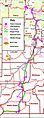
Fort Walla Walla–Fort Colville Military Road Route 1859–82
