Washtucna, Washington facts for kids
Quick facts for kids
Washtucna
|
|
|---|---|
| Washtucna, Washington | |

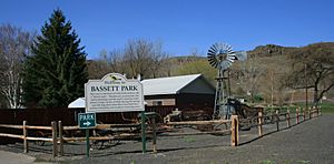
Bassett Park in Washtucna
|
|

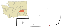
Location of Washtucna, Washington
|
|
| Country | United States |
| State | Washington |
| County | Adams |
| Area | |
| • Total | 0.66 sq mi (1.71 km2) |
| • Land | 0.66 sq mi (1.71 km2) |
| • Water | 0.00 sq mi (0.00 km2) |
| Elevation | 1,027 ft (313 m) |
| Population
(2020)
|
|
| • Total | 211 |
| • Density | 320/sq mi (123.4/km2) |
| Time zone | UTC-8 (Pacific (PST)) |
| • Summer (DST) | UTC-7 (PDT) |
| ZIP code |
99371
|
| Area code | 509 |
| FIPS code | 53-76440 |
| GNIS feature ID | 1509318 |
Washtucna is a small town in Adams County, Washington, United States. In 2020, about 211 people lived there. This was a small increase from the last count. The town got its name from a lake nearby. This lake was named after a leader of the Palouse Native American tribe.
Contents
History of Washtucna
The area where Washtucna now stands was first settled in 1878. George Bassett and his wife, Alice, moved there from Iowa. They wanted to raise horses. Until 1900, their ranch was a place where wild horses were rounded up every year.
In 1882, the first Post Office in Adams County opened here. George Bassett was the first postmaster. Later, in 1894, T.C. Martin took over the post office. He also opened the town's first store. The town was named after a Palouse leader called "Washtucna."
The first railroad line reached the area in 1886. It was built by the Oregon Improvement Company. In its first five years, this railroad shipped 30,000 bushels of wheat. People tried to start large irrigation projects between 1892 and 1917. However, none of them worked out. Because of this, farmers continued to grow wheat without irrigation.
Washtucna officially became a town on October 27, 1903. Charles T. Booth was chosen as its first mayor. In the early 2000s, the town faced some money problems. This was due to less state funding and lower wheat sales.
Geography of Washtucna
Washtucna is located at 46°45'12" North and 118°18'46" West. It sits at the start of Washtucna Coulee. A coulee is a long, narrow valley. This valley runs west to Connell, Washington. There, it joins with another coulee to form Esquatzel Coulee.
Because Washtucna is on the floor of this valley, it is lower than the land around it. The valley floor in Washtucna is about 1,027 feet (313 meters) above sea level. But the valley walls quickly rise to 1,600 feet (488 meters) nearby.
Washtucna is found where State Routes 26 and 261 meet. It is about 65 miles (105 km) west of Pullman, Washington. It's also about 86 miles (138 km) southwest of Spokane, Washington. Seattle, Washington, is about 220 miles (354 km) to the east. The Columbia Plateau Trail also goes through Washtucna.
The Palouse River flows a few miles east of Washtucna today. But a long time ago, the river used to flow right through Washtucna. It went down Washtucna Coulee. Eventually, the river changed its path. During the Missoula Floods, huge amounts of water flowed through the old riverbed. This history means the Washtucna area has features from two different regions. These are the Channeled Scablands to the north and west, and the Palouse to the south and east.
The United States Census Bureau says the town covers about 0.69 square miles (1.79 square kilometers). All of this area is land.
Population and People
| Historical population | |||
|---|---|---|---|
| Census | Pop. | %± | |
| 1910 | 300 | — | |
| 1920 | 359 | 19.7% | |
| 1930 | 261 | −27.3% | |
| 1940 | 285 | 9.2% | |
| 1950 | 316 | 10.9% | |
| 1960 | 331 | 4.7% | |
| 1970 | 316 | −4.5% | |
| 1980 | 266 | −15.8% | |
| 1990 | 231 | −13.2% | |
| 2000 | 260 | 12.6% | |
| 2010 | 208 | −20.0% | |
| 2020 | 211 | 1.4% | |
| U.S. Decennial Census | |||
How Many People Live Here?
In 2010, there were 208 people living in Washtucna. These people lived in 97 households, and 62 of these were families. The town had about 301 people per square mile. There were 126 homes in total.
Most of the people in town, about 95.2%, were White. A small number were African American (1.0%) or Native American (1.4%). About 2.4% of the population was Hispanic or Latino.
Households and Families
Out of the 97 households, about 18.6% had children under 18 living with them. Nearly half, 47.4%, were married couples living together. About 11.3% of households had a female head with no husband. Also, 5.2% had a male head with no wife. About 36.1% of households were not families.
Almost 31% of all households were made up of people living alone. About 9.3% of these were people aged 65 or older living by themselves. On average, each household had 2.14 people. The average family had 2.63 people.
The average age of people in Washtucna was 51.6 years. About 17.3% of residents were under 18. About 25% were 65 years or older. The town had more males (57.2%) than females (42.8%).
See also
 In Spanish: Washtucna (Washington) para niños
 | Leon Lynch |
 | Milton P. Webster |
 | Ferdinand Smith |


