Palouse Falls facts for kids
Quick facts for kids Palouse Falls |
|
|---|---|

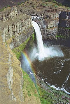
Palouse Falls during high flow, viewed from the west side of the canyon
|
|
| Lua error in Module:Infobox_mapframe at line 185: attempt to index field 'wikibase' (a nil value). | |
| Location | Franklin / Whitman counties, Washington, United States |
| Coordinates | 46°39′49″N 118°13′25″W / 46.66361°N 118.22361°W |
| Elevation | 725 feet (221 m) |
| Total height | 200 feet (61 m) |
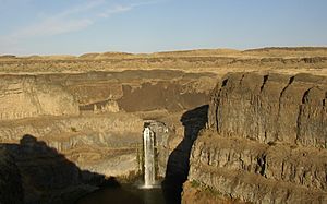
The Palouse Falls are amazing waterfalls located on the Palouse River in southeast Washington, United States. They are about 4 mi (6 km) away from where the Palouse River joins the Snake River. The main part of the falls is about 198 ft (60 m) tall. There's also a smaller upper fall about 20 ft (6.1 m) high, located about 1,000 ft (305 m) upstream from the main drop.
Contents
How Palouse Falls Was Formed
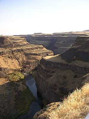
The canyon at Palouse Falls is about 115 m (377 ft) deep. It shows layers of rock called the Columbia River Basalt Group. These layers were formed by ancient lava flows.
The falls and the canyon were created by huge floods. These floods are known as the Missoula floods. They happened many times during the Pleistocene Ice Age. These floods carved out unique landscapes called the Channeled Scablands.
Before these floods, the Palouse River flowed differently. It used to go through a dry channel called Washtucna Coulee. This channel led to the Columbia River. But the Missoula floods were so powerful that they changed the river's path. The floods broke through the old valley wall. They carved a new path for the Palouse River. This new path led to the Snake River, creating the falls we see today.
The area around the falls has many interesting features. You can see deep channels called coulees. There are also plunge pools, which are deep holes at the bottom of waterfalls. You might also spot tall rock formations called buttes and pinnacles. These are all signs of the massive floods that shaped this land.
Protecting Palouse Falls: A Look at Past Proposals
In 1984, there was a plan to build a dam near the falls. The Franklin County Public Utility District suggested building a 98-foot-high (30 m) dam. This dam would have been built upstream from the falls. It was meant to create hydroelectric power. This power could have provided a lot of electricity for the county. It would have also lowered electricity bills for people living there.
However, most people in the county decided not to approve the plan. They wanted to protect this special natural area. Because of their decision, the falls remain a beautiful and important geological site today.
Exploring Palouse Falls State Park
Palouse Falls is part of Washington's Palouse Falls State Park. This park lets visitors get close to the falls. It also has signs that explain the area's unique geology. You can learn about the history of the Palouse Indians here. They used this area because it was easy to reach the plateau. The historic Mullan Road also passed nearby.
The park has a special viewpoint for the falls. It's just a short walk from the parking area. There's also a campground and a picnic area for visitors. The park department is also working on building more trails for people to explore.
Kayaking Down the Falls
On April 21, 2009, a kayaker named Tyler Bradt did something amazing. He kayaked down Palouse Falls. This was an unofficial world record for the highest waterfall run. Bradt's team shared a video of his incredible drop. It was shown on the Sports Illustrated website. The magazine also featured a two-page photo of his feat. His photos were even published in Spain's Hola magazine.
How Tall Are the Falls?
After Tyler Bradt's record-setting kayak run, people started wondering about the exact height of the falls. Bradt's team measured the falls themselves. They said the main drop was 186 ft (57 m) from the top pool to the bottom plunge pool.
A local newspaper, The Spokesman-Review, asked Washington state officials about the height. The state said their last measurement was from 1945. They used older methods back then. The state wasn't ready to do a new measurement with modern laser equipment.
However, a geology professor from Whitman College led a team of students. They studied the falls' height and found some interesting things:
- The height of both the top pool and the plunge pool changes. This depends on how much water is flowing in the river.
- In 2009, the river's highest flow was on January 9. At that time, the top pool was 12 ft (3.7 m) higher than when measurements were taken in August.
- The plunge pool's elevation also changed. It was about 7 ft (2.1 m) different between January and August.
- This means the height of the falls could change by about 5-foot (1.5 m) during the year.
- They estimated that during Bradt's record attempt, the main drop was likely between 175 and 180 ft (55 m) tall.
Washington's Official State Waterfall
On February 12, 2014, something special happened for Palouse Falls. The Washington House of Representatives voted to make it the official state waterfall. They passed a bill called HB 2119. This idea actually came from a group of elementary school students! These students from the nearby town of Washtucna worked hard to convince the state legislature.
See also
 In Spanish: Catarata Palouse para niños
 | Laphonza Butler |
 | Daisy Bates |
 | Elizabeth Piper Ensley |


