
Lincoln County, Washington facts for kids
Quick facts for kids
Lincoln County
|
|
|---|---|

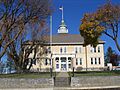
Lincoln County Courthouse
|
|

Location within the U.S. state of Washington
|
|
 Washington's location within the U.S. |
|
| Country | |
| State | |
| Founded | November 24, 1883 |
| Named for | Abraham Lincoln |
| Seat | Davenport |
| Largest city | Davenport |
| Area | |
| • Total | 2,339 sq mi (6,060 km2) |
| • Land | 2,310 sq mi (6,000 km2) |
| • Water | 29 sq mi (80 km2) 1.2%% |
| Population
(2020)
|
|
| • Total | 10,876 |
| • Estimate
(2023)
|
11,738 |
| • Density | 4.6499/sq mi (1.7953/km2) |
| Time zone | UTC−8 (Pacific) |
| • Summer (DST) | UTC−7 (PDT) |
| Congressional district | 5th |
Lincoln County is a county located in the U.S. state of Washington. In 2020, about 10,876 people lived there. This makes it one of the least populated counties in the state. The main city and county seat is Davenport.
Lincoln County was formed in November 1883. It is named after Abraham Lincoln, who was the 16th president of the United States.
Contents
History of Lincoln County
Lincoln County was created in 1883. It was formed from a part of Spokane County. Just four days later, another part of its land was used to create Douglas County. The county's borders have not changed since then.
The name "Sprague County" was first suggested. This was to honor General John W. Sprague. However, lawmakers had objections, so the name Lincoln County was chosen instead. Lincoln County covers about 2,317 square miles. This makes it the eighth-largest county by area in Washington state.
Early Explorers and Settlers
Hundreds of years ago, the area of Lincoln County was a path for native peoples. A spring near where Davenport is today was a popular camping spot.
The famous Lewis and Clark Expedition did not explore this far north. The first European explorer to record visiting the area was David Thompson in 1811. He was a scout for the North West Company. Thompson wrote about places in Lincoln County, like 'Strong Rapid' on the Columbia River. This part of the river is now calm because of the Grand Coulee Dam.
After Thompson, many fur trappers and explorers visited. One of them was the Scottish botanist David Douglas in 1826.
The first non-native person to live permanently in the area might have been R.M. Bacon. He came from Boston and started raising cattle around Crab Creek in 1871. Bacon also became the first postmaster when the county's first post office opened.
More people began moving to the area in the late 1870s. The completion of the Northern Pacific Railway in 1883 helped settlement grow quickly. The building of Fort Spokane between 1880 and 1882 also encouraged people to settle there.
Geography and Climate
Lincoln County is located in an area called the Channeled Scablands. This region is also known as the Big Bend Plateau. The land here is between 1,500 and 2,500 feet above sea level. It has many channels carved into the rock by ancient glacial rivers. These rivers flowed from northeastern Washington.
Weather Patterns
Lincoln County has hot and dry summers. Winters are cold and somewhat humid. The land is mostly flat, so temperatures do not change much from east to west. Rainfall varies across the county. The western part is very dry, while the northeast is semi-dry.
The entire county is in a dry basin between the Cascade Mountains and the Rocky Mountains. Rainfall is very important for farming here. The Big Bend region gets between 8 and 20 inches of rain each year.
Average monthly temperatures range from below freezing in winter. In mid-summer, temperatures are usually between 65 and 71 °F.
Land and Water Area
The United States Census Bureau states that Lincoln County covers 2,339 square miles in total. Of this, 2,310 square miles is land. The remaining 29 square miles (1.2%) is water.
Key Geographic Features
- Channeled Scablands
- Columbia River
- Crab Creek
- Lilienthal Mountain, the highest point in the county
Major Roads and Highways
 Interstate 90
 U.S. Route 2
 U.S. Route 395
Neighboring Counties
- Okanogan County – northwest
- Ferry County – north
- Stevens County – northeast
- Spokane County – east
- Whitman County – southeast
- Adams County – south
- Grant County – west
Protected Natural Areas
- Lake Roosevelt National Recreation Area (part)
Population and People
| Historical population | |||
|---|---|---|---|
| Census | Pop. | %± | |
| 1890 | 9,312 | — | |
| 1900 | 11,969 | 28.5% | |
| 1910 | 17,539 | 46.5% | |
| 1920 | 15,141 | −13.7% | |
| 1930 | 11,876 | −21.6% | |
| 1940 | 11,361 | −4.3% | |
| 1950 | 10,970 | −3.4% | |
| 1960 | 10,919 | −0.5% | |
| 1970 | 9,572 | −12.3% | |
| 1980 | 9,604 | 0.3% | |
| 1990 | 8,864 | −7.7% | |
| 2000 | 10,184 | 14.9% | |
| 2010 | 10,570 | 3.8% | |
| 2020 | 10,876 | 2.9% | |
| 2023 (est.) | 11,738 | 11.1% | |
| U.S. Decennial Census 1790–1960 1900–1990 1990–2000 2010–2020 |
|||
2010 Census Information
In 2010, there were 10,570 people living in Lincoln County. These people lived in 4,422 households, and 3,059 of these were families. The county had about 4.6 people per square mile. There were 5,776 homes, with about 2.5 homes per square mile.
Most of the people in the county were white (95.0%). Other groups included American Indian (1.6%), Asian (0.4%), and Black (0.3%). About 2.3% of the population was of Hispanic or Latino origin. Many people had German (42.3%), Irish (14.6%), or English (13.9%) backgrounds.
About 25.9% of households had children under 18 living with them. Most households (57.3%) were married couples. The average household had 2.37 people, and the average family had 2.85 people. The average age of people in the county was 47.6 years old.
The average income for a household was $45,582. For families, it was $52,083. About 12.1% of all people, and 21.5% of those under 18, lived below the poverty line.
Economy and Farming
Lincoln County's economy mainly depends on agriculture. The most important crop is wheat. Lincoln County is often considered the second-largest wheat producer in the United States. Whitman County, Washington is usually the largest. Lincoln County can produce as much as 25 million bushels (680,000 tons) of wheat each year.
Farmers in the county often use a method called "summer-fallow." This means they harvest one crop every two years. Only about 500,000 of the 900,000 acres of farmland are planted each year. This is necessary because the region only gets about 12 inches of rain annually.
Raising livestock (farm animals) is also important in the county. However, it is a much smaller part of the economy compared to crop farming. For example, in 1954, the county was third in the state for crop income. But it was only 21st for income from livestock.
Communities in Lincoln County
Cities
- Davenport (county seat)
- Harrington
- Sprague
Towns
Unincorporated Communities
Ghost Towns
Images for kids
-
Lincoln County Courthouse
See also
 In Spanish: Condado de Lincoln (Washington) para niños
