
Spokane River facts for kids
Quick facts for kids Spokane River |
|
|---|---|

Spokane River in Lincoln County, 1909
|
|

Spokane River watershed
|
|
| Country | United States |
| State | Washington, Idaho |
| County | Kootenai, Spokane, Stevens, Lincoln |
| Physical characteristics | |
| Main source | Lake Coeur d'Alene Kootenai County, Idaho 1,994 ft (608 m) 47°40′41″N 117°07′34″W / 47.67806°N 117.12611°W |
| River mouth | Columbia River at Lake Roosevelt, Washington 1,293 ft (394 m) 47°53′38″N 118°20′03″W / 47.89389°N 118.33417°W |
| Length | 111 mi (179 km) |
| Basin features | |
| Basin size | 6,020 sq mi (15,600 km2) |
The Spokane River is a river in the United States. It flows for about 111 miles (179 km) through northern Idaho and eastern Washington. This river is a branch, or tributary, of the big Columbia River. It helps drain water from mountains east of the Columbia. The river also flows through the Spokane Valley and the city of Spokane, Washington.
Contents
About the Spokane River
The Spokane River starts from the northern part of Lake Coeur d'Alene in Idaho. It then flows into Franklin D. Roosevelt Lake, which is part of the Columbia River. This is about 112 miles (180 km) downstream.
After leaving Lake Coeur d'Alene, the river flows across the Rathdrum Prairie. It reaches Post Falls, Idaho, where it goes over a dam and a natural 40-foot waterfall. As it continues west, it passes over six more dams. Three of these dams are in the city of Spokane. In Spokane, the river flows over the Spokane Falls. These waterfalls are right in the middle of Downtown Spokane.
About a mile after the falls, Latah Creek joins the Spokane River from the southeast. Soon after, the Little Spokane River joins it from the northeast, on the western edge of Spokane city. The river then flows in a zigzag path along the southern edge of the Selkirk Mountains. It forms the southern border of the Spokane Indian Reservation. Here, the Long Lake Dam holds back the water, creating Long Lake. This lake is a reservoir about 15 miles (24 km) long. Finally, the Spokane River joins Franklin D. Roosevelt Lake on the Columbia River at Miles. The old Fort Spokane is located where the Spokane and Columbia rivers meet.
The entire area that the Spokane River drains is called its drainage basin. This basin is about 6,240 square miles (16,160 km²) large. About 3,840 square miles (9,945 km²) of this area are above the Post Falls Dam. The river's average water flow is about 7,946 cubic feet per second (225 m³/s).
People and the River
For many years, the Coeur d'Alene and Spokane Native American tribes lived along the Spokane River. They traveled and used the river for their daily lives.
In 1807, David Thompson was the first European explorer to cross the Rocky Mountains and explore this area.
Today, many people live near the Spokane River. The city of Spokane, Washington is the largest city on its banks, with over 213,000 people. The cities of Coeur d'Alene and Post Falls in Idaho also sit along the river. The Spokane River and Lake Coeur d'Alene are very important. They help refill the Spokane Valley–Rathdrum Prairie Aquifer. This aquifer is the main source of drinking water for all these cities.
River Health and Pollution
The Spokane River has some of the highest levels of heavy metals of any river in Washington. This pollution comes from Lake Coeur d'Alene and travels from the Bunker Hill Mine and Smelting Complex. This area is a "Superfund Site," meaning it's a place with serious pollution that needs a lot of cleanup.
The city of Spokane's sewage treatment plants release their treated water into the Spokane River. In 1889, Spokane built a sewage system that put raw sewage directly into the river. By 1920, this was very noticeable. In 1957, a basic treatment plant was built. However, the Washington State Department of Ecology soon said it wasn't good enough. This led to a more advanced treatment plant being built. It started working in 1977 and used special technology to clean the water better.
Fish in the River

When the Northern Pacific Railway lines reached Spokane in 1882, many mills were built along the river. These mills needed dams to power their machines. Because the dams blocked the river, the number of salmon in the Spokane River dropped a lot. People living upstream were very unhappy about this. After the Little Falls Dam was built in 1910, salmon could no longer swim upstream. This caused the river's salmon populations to disappear completely.
Steelhead were also very common in the Spokane River before pollution and dams. Today, the Spokane River system is one of the largest areas where steelhead used to live but no longer do.
Today, the Spokane River is home to rainbow trout, northern pikeminnow, and Bridgelip Suckers. There are also some fish species that are not native to the area. However, many of the fish that remain are not safe for people to eat. This is because of chemical pollution in the river. Signs along the river warn that the fish are contaminated with PCBs.
River Crossings
Images for kids
-
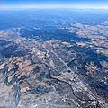
An aerial view of the Spokane River in Spokane, with Lake Coeur d'Alene in the background.

See also
 In Spanish: Río Spokane para niños
