Garrison, Montana facts for kids
Quick facts for kids
Garrison, Montana
|
|
|---|---|

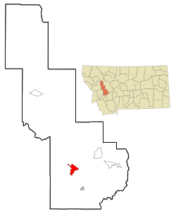
Location of Garrison, Montana
|
|
| Country | United States |
| State | Montana |
| County | Powell |
| Area | |
| • Total | 9.64 sq mi (24.96 km2) |
| • Land | 9.63 sq mi (24.95 km2) |
| • Water | 0.00 sq mi (0.01 km2) |
| Elevation | 4,374 ft (1,333 m) |
| Population
(2020)
|
|
| • Total | 115 |
| • Density | 11.94/sq mi (4.61/km2) |
| Time zone | UTC-7 (Mountain (MST)) |
| • Summer (DST) | UTC-6 (MDT) |
| ZIP code |
59731
|
| Area code(s) | 406 |
| FIPS code | 30-30175 |
| GNIS feature ID | 0771720 |
Garrison is a small community in Powell County, Montana, United States. It is called a census-designated place (CDP) because it's a special area used for gathering population data. In 2020, about 115 people lived here.
The native Salish people had a name for this area: snx̣ʷq̓pusaqs. It was a place where different groups would meet and then go their separate ways, some heading towards Helena and others towards Butte.
History of Garrison
A post office opened in Garrison in 1883 and served the community until 2015. The town was named after William Lloyd Garrison. He was an important person who worked to end slavery, known as an abolitionist. William Lloyd Garrison was also the father-in-law of Henry Villard. Villard was the person who helped finish the Northern Pacific Railroad in 1883.
Garrison is located just east of Gold Creek. This is where a special "golden spike" was hammered into the ground on September 8, 1883. This event marked the completion of the railroad line. Even former President Ulysses S. Grant was there for the big day!
Garrison was also a key spot for the Northern Pacific Railroad. It was a "division point," meaning trains would split up here. Some trains would go east towards Helena, while others would go south and east towards Butte. Today, other railway companies like Burlington Northern, Montana Rail Link, and BNSF still use this route. Trains heading to Helena cross Mullan Pass. Near Butte, they use Homestake Pass. These train lines meet up again in Logan, Montana, close to Three Forks.
Geography of Garrison
Garrison is located at 46°32′15″N 112°49′35″W / 46.53750°N 112.82639°W. This means it's in a specific spot on the map.
According to the United States Census Bureau, Garrison covers an area of about 9.5 square miles (24.9 square kilometers). All of this area is land.
Population and People
| Historical population | |||
|---|---|---|---|
| Census | Pop. | %± | |
| 2020 | 115 | — | |
| U.S. Decennial Census | |||
In 2000, there were 112 people living in Garrison. Most of the people living here were White. About 4.5% were Native American. A small number of people were from two or more races. About 1.8% of the population was Hispanic or Latino.
The average age of people in Garrison in 2000 was 46 years old. About 20.5% of the population was under 18 years old.
See also
In Spanish: Garrison (Montana) para niños
 | Charles R. Drew |
 | Benjamin Banneker |
 | Jane C. Wright |
 | Roger Arliner Young |


