
Kamiak Butte facts for kids
Quick facts for kids Kamiak Butte County Park |
|
|---|---|

The southern slopes of Kamiak Butte, with wheat fields beyond
|
|
| Location | Whitman County, Washington, USA |
| Area | 298 acres (121 ha) |
| Operated by | Whitman County Parks and Recreation Department |
| Designated: | 1965 |
Kamiak Butte County Park is a special place located in Whitman County, Washington. It's found in Eastern Washington, close to the Idaho border, between the towns of Palouse and Pullman. This park is named after Chief Kamiakin, a respected leader of the Yakama tribe.
Most of the park covers about 298 acres (121 ha). It's mostly timberland, which means it's covered in trees on the northern side of Kamiak Butte.
Contents
What is Kamiak Butte?
Kamiak Butte is like a tall "island" of rock. It's made of a very old type of rock called Precambrian quartzite. This rock sticks up about 1,000 feet (300 m) above the flat wheat fields around it. The reddish rocks were once part of an ancient sea bed. If you look closely, you can still see tiny grains of sand sparkling in the sun!
Much later, Kamiak Butte became part of a mountain range. Over time, most of this mountain range was covered by huge lava flows. These lava flows happened during the Cenozoic Era and covered most of Eastern Washington with a thick layer of basalt rock.
Plants and Animals of Kamiak Butte
The area around Kamiak Butte is used a lot for farming wheat and lentils. Because of this, Kamiak Butte has become a very important safe place for local plants and animals. It's like a natural refuge!
Scientists have found many different kinds of living things in the park:
- Over 170 types of plants
- More than 140 kinds of birds
- About 30 different types of mammals
This makes Kamiak Butte a great spot to see nature up close.
Exploring the Park: Trails and Activities
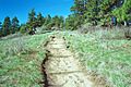
One of the most popular things to do at Kamiak Butte County Park is to hike the Pine Ridge Trail.
The Pine Ridge Trail
The Pine Ridge Trail is a 3.5-mile (5.6 km) loop trail. It starts at a parking area and goes up through a forest of evergreen trees. The trail then follows an open ridge, where you can see amazing views of the surrounding Palouse countryside. After the ridge, the trail goes back down into the forest.
There's also a short path called the "summit spur." This path leads to the highest point of the mountain. It's a rocky spot on the west side, about 3,641 feet (1,110 m) high.
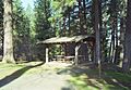
Camping and Other Fun Things
You can go camping at Kamiak Butte almost all year round. However, during very dry times, camping might be stopped because of the risk of fires.
The park also offers many other things to do:
- Interpretive programs: These are special events in the spring and summer where you can learn more about the park's nature and history.
- Amphitheater: A place for outdoor performances or talks.
- Picnic tables and outdoor grills: Perfect for a family meal outside.
- Covered shelters: Places to stay dry if it rains.
- Restrooms: For your convenience.
- Playground: A fun area for younger visitors.
Special Designations
Kamiak Butte is recognized as a very important natural area. Along with Steptoe Butte, it is a National Natural Landmark. This means it has unique geological features.
The Pine Ridge Trail is also special. It's listed as a National Recreation Trail within the National Trails System. This shows it's a great trail for people to enjoy the outdoors.
Images for kids
-
Pine Ridge Trail on Kamiak Butte
-
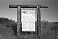
Kamiak Butte information sign
-
Picnic table at Kamiak Butte


